Category:Ladbroke, Warwickshire
Jump to navigation
Jump to search
village and civil parish in Warwickshire, UK  | |||||
| Upload media | |||||
| Instance of | |||||
|---|---|---|---|---|---|
| Location | Stratford-on-Avon, Warwickshire, West Midlands, England | ||||
| Population |
| ||||
| Area |
| ||||
| official website | |||||
 | |||||
English: Ladbroke is a village and civil parish in Warwickshire, England. It is approximately south of Southam, and is in Stratford-on-Avon district. The earliest documented evidence of the village's existence is in the Domesday Book, a survey of England which was completed in 1086.
Subcategories
This category has only the following subcategory.
L
- All Saints Church, Ladbroke (8 F)
Media in category "Ladbroke, Warwickshire"
The following 53 files are in this category, out of 53 total.
-
 Alongside Windmill Hill Spinney - geograph.org.uk - 5999618.jpg 768 × 1,024; 224 KB
-
 Approaching Southam Road - geograph.org.uk - 5999621.jpg 1,024 × 768; 167 KB
-
 Arable land near Ladbroke - 1 - geograph.org.uk - 2732701.jpg 3,648 × 2,736; 3.42 MB
-
 Arable land near Ladbroke - 2 - geograph.org.uk - 2732708.jpg 3,648 × 2,736; 3.59 MB
-
 B4451 junction with Harbury Road - geograph.org.uk - 3105297.jpg 3,648 × 2,736; 1.39 MB
-
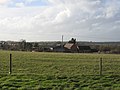
 Deppers Bridge Farm - geograph.org.uk - 6387179.jpg 800 × 533; 156 KB
-
 Derelict farm machinery - geograph.org.uk - 6387215.jpg 800 × 533; 158 KB
-
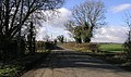
 Farm Track - geograph.org.uk - 3476652.jpg 640 × 480; 57 KB
-
 Field off Ladbroke Road near to Folly Fields Farm - geograph.org.uk - 2127708.jpg 2,000 × 1,500; 247 KB
-
 Folly Fields Farm - geograph.org.uk - 6387201.jpg 800 × 533; 158 KB
-
 Footpath towards Ladbroke - geograph.org.uk - 5999622.jpg 768 × 1,024; 314 KB
-
 Footpath towards Starbold Farm - geograph.org.uk - 5999627.jpg 1,024 × 768; 220 KB
-
 Junction of Harbury Road and Ladbroke Road - geograph.org.uk - 2127761.jpg 2,000 × 1,500; 210 KB
-
 Junction of Ladbroke Road and Harbury Road - geograph.org.uk - 2127752.jpg 2,000 × 1,500; 208 KB
-
 Ladbroke - Church Cottage - 20201212121829.jpg 4,032 × 3,024; 4.47 MB
-
 Ladbroke - Stable Block Approximately 8 Metres North Of The Old Rectory - 20201212121604.jpg 4,032 × 3,024; 3.68 MB
-
 Ladbroke - The Old Rectory - 20201212121535.jpg 4,032 × 3,024; 3.02 MB
-
 Ladbroke By-Pass - geograph.org.uk - 2838063.jpg 640 × 481; 52 KB
-
 Ladbroke Farmland - geograph.org.uk - 2626818.jpg 640 × 480; 89 KB
-
 Ladbroke Hall (geograph 6996132).jpg 1,600 × 1,200; 682 KB
-
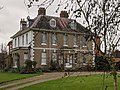
 Ladbroke House - geograph.org.uk - 144317.jpg 640 × 480; 411 KB
-
 Ladbroke Parish church in the distance - geograph.org.uk - 5999626.jpg 768 × 1,024; 181 KB
-
 Ladbroke, Warks.jpg 640 × 480; 365 KB
-
 Ladbroke-Banbury Road - geograph.org.uk - 1440862.jpg 640 × 480; 57 KB
-
 Ladbroke-Church Road - geograph.org.uk - 4729172.jpg 1,600 × 1,200; 476 KB
-
 Ladbroke-Radbourne Lane - geograph.org.uk - 2627029.jpg 640 × 480; 81 KB
-
 Ladbroke-The Bell Inn - geograph.org.uk - 1433617.jpg 640 × 480; 75 KB
-
 Ladbroke-The Old Forge - geograph.org.uk - 4729184.jpg 1,600 × 1,064; 484 KB
-
 Ladbroke-Windmill Hill - geograph.org.uk - 2626848.jpg 640 × 480; 51 KB
-
 Manor Farm - geograph.org.uk - 2555851.jpg 2,000 × 1,497; 498 KB
-
 Oilseed rape field near Southam - geograph.org.uk - 3944175.jpg 640 × 427; 91 KB
-
 Old Toll House by Banbury Road, Ladbroke - geograph.org.uk - 6115217.jpg 640 × 485; 111 KB
-
 Ordnance Survey Drawings - Ladbroke, Warwickshire (OSD 227).jpg 4,000 × 2,904; 3.26 MB
-
 Pasture off Ladbroke Road near to Folly Fields Farm - geograph.org.uk - 2127723.jpg 2,000 × 1,500; 217 KB
-
 Path towards Windmill Hill Spinney - geograph.org.uk - 5999616.jpg 1,024 × 768; 185 KB
-
 Poor Crop Growth - geograph.org.uk - 3476640.jpg 640 × 480; 73 KB
-
 Rectory Farm - geograph.org.uk - 6387225.jpg 800 × 533; 108 KB
-
 Straw bales in a field - geograph.org.uk - 2555835.jpg 2,000 × 1,493; 325 KB
-
 Track towards Ladbroke - geograph.org.uk - 5999625.jpg 768 × 1,024; 295 KB
-
 View NE from Ladbroke Road near to Folly Fields Farm - geograph.org.uk - 2127736.jpg 2,000 × 1,500; 214 KB
-
 Welsh Road East towards Southam - geograph.org.uk - 6241250.jpg 800 × 600; 158 KB
-
 Ascote - geograph.org.uk - 146716.jpg 640 × 480; 278 KB
-
 Deppers Bridge Farm - geograph.org.uk - 144319.jpg 640 × 480; 279 KB
-
 Harbury Lane - geograph.org.uk - 118894.jpg 640 × 379; 111 KB
-
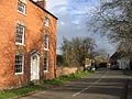
 Ladbroke - geograph.org.uk - 144311.jpg 640 × 480; 330 KB
-
 Ladbroke Grove Farm - geograph.org.uk - 146714.jpg 640 × 480; 263 KB
-
 Napton Holt - geograph.org.uk - 19276.jpg 640 × 480; 54 KB
-
 Rural railway - geograph.org.uk - 221500.jpg 640 × 505; 41 KB
-
 View from Windmill Lane - geograph.org.uk - 144298.jpg 640 × 480; 250 KB
-
 Windmill Hill - geograph.org.uk - 144302.jpg 640 × 480; 263 KB
-
 Windmill Hill - geograph.org.uk - 144305.jpg 640 × 480; 282 KB
-
 Windmill Hill - geograph.org.uk - 144308.jpg 640 × 480; 293 KB
-
 Windmill Lane, Ladbroke - geograph.org.uk - 144312.jpg 640 × 480; 261 KB


.jpg)


.jpg)


