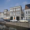
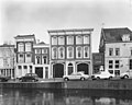
Category:Lage Gouwe 142, Gouda
Jump to navigation
Jump to search
| Object location | | View all coordinates using: OpenStreetMap |
|---|
 | |||||
| Upload media | |||||
| Instance of |
| ||||
|---|---|---|---|---|---|
| Location | Gouda, South Holland, Netherlands | ||||
| Street address |
| ||||
| Located on street | |||||
| Heritage designation |
| ||||
 | |||||
|
This is a category about rijksmonument number 16798
|
| Address |
|
Media in category "Lage Gouwe 142, Gouda"
The following 7 files are in this category, out of 7 total.
-
 Lage Gouwe 142 Gouda.jpg 1,032 × 1,780; 476 KB
-
 Overzicht - Gouda - 20082322 - RCE.jpg 804 × 1,200; 220 KB
-

-
 Overzicht van de voorgevels - Gouda - 20379869 - RCE.jpg 1,200 × 1,180; 275 KB
-

-
 Voorgevel - Gouda - 20082485 - RCE.jpg 1,200 × 960; 205 KB
-
 Voorgevel - Gouda - 20082487 - RCE.jpg 1,200 × 965; 195 KB


