Category:Landgoed Kamps
Jump to navigation
Jump to search
|
This is a category about rijksmonument number 32701
|
| Object location | | View all coordinates using: OpenStreetMap |
|---|
farmhouse in Aa en Hunze, Netherlands  | |||||
| Upload media | |||||
| Instance of | |||||
|---|---|---|---|---|---|
| Location | Aa en Hunze, Drenthe, Netherlands | ||||
| Street address |
| ||||
| Heritage designation | |||||
 | |||||
Media in category "Landgoed Kamps"
The following 8 files are in this category, out of 8 total.
-
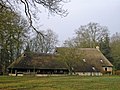
 Asserstraat, Boerderij Kamps, huis - Rolde - 20190066 - RCE.jpg 1,200 × 805; 260 KB
-
 Asserstraat, Boerderij Kamps, schuren - Rolde - 20190067 - RCE.jpg 1,200 × 804; 254 KB
-
 Asserstraat, Boerderij Kamps, situatie - Rolde - 20190065 - RCE.jpg 1,200 × 805; 227 KB
-
 Boerderij Kamps 2.JPG 2,048 × 1,536; 602 KB
-
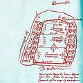 Boerderij Kamps grondschattingsregister 1642-1654.jpg 1,203 × 1,204; 256 KB
-
 Boerderij met schuren en erf Coll. Landweer - Balloo - 20469134 - RCE.jpg 1,200 × 900; 109 KB
-
 Boerderij met schuren en erf nr. F 168-32 - Balloo - 20469135 - RCE.jpg 1,200 × 900; 138 KB
-
 Kamps baander.JPG 2,048 × 1,536; 566 KB


