Category:Landkreis Fulda
Jump to navigation
Jump to search
Districts of Hesse:
Bergstraße · Darmstadt-Dieburg · Fulda · Gießen · Groß-Gerau · Hersfeld-Rotenburg · Hochtaunus · Kassel · Lahn-Dill · Limburg-Weilburg · Main-Kinzig · Main-Taunus · Marburg-Biedenkopf · Odenwald · Offenbach · Rheingau-Taunus · Schwalm-Eder · Vogelsberg · Waldeck-Frankenberg · Werra-Meißner · Wetterau
Urban districts (cities):
district in Hesse, Germany    | |||||
| Upload media | |||||
| Instance of | |||||
|---|---|---|---|---|---|
| Named after | |||||
| Location | Kassel Government Region, Hesse, Germany | ||||
| Capital | |||||
| Population |
| ||||
| Area |
| ||||
| Elevation above sea level |
| ||||
| official website | |||||
 | |||||
Français : L'arrondissement de Fulda est un arrondissement de Hesse situé dans le district de Cassel. Son chef lieu est Fulda.
Subcategories
This category has the following 24 subcategories, out of 24 total.
B
- Boundary stones in Fulda (12 F)
- Bus stops in Landkreis Fulda (43 F)
F
- Aerial photographs of Fulda (17 F)
M
P
R
S
- Schools in Landkreis Fulda (2 F)
Media in category "Landkreis Fulda"
The following 37 files are in this category, out of 37 total.
-
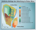 Abtorfung Rotes Moor.png 1,967 × 1,626; 241 KB
-
 Ausschnitt Landkarte Hochstift Fulda von Regerwill 1574.jpg 800 × 581; 312 KB
-
 Herbst I (48993650).jpeg 2,048 × 1,365; 252 KB
-
 Herbst Ii (48993606).jpeg 2,048 × 1,365; 167 KB
-
 KFZ-Zulassungsplakette des Landkreises Fulda-neu.JPG 1,168 × 1,144; 258 KB
-
 North of Fulda 2019-07-14 01.jpg 5,184 × 3,888; 8.1 MB
-
 North of Fulda 2019-07-14 02.jpg 5,184 × 3,888; 8.12 MB
-
 North of Fulda 2019-07-14 03.jpg 5,184 × 3,888; 8.86 MB
-
 North of Fulda 2019-07-14 04.jpg 5,184 × 3,888; 9.3 MB
-
 North of Fulda 2019-07-14 05.jpg 5,184 × 3,888; 9.35 MB
-
 North of Fulda 2019-07-14 06.jpg 5,184 × 3,888; 10.01 MB
-
 North of Fulda 2019-07-14 07.jpg 5,184 × 3,888; 8.4 MB
-
 North of Fulda 2019-07-14 08.jpg 5,184 × 3,888; 9.67 MB
-
 North of Fulda 2019-07-14 09.jpg 5,184 × 3,888; 8.1 MB
-
 North of Fulda 2019-07-14 10.jpg 5,184 × 3,888; 9.37 MB
-
 North of Fulda 2019-07-14 11.jpg 5,184 × 3,888; 10 MB
-
 North of Fulda 2019-07-14 12.jpg 5,184 × 3,888; 10.32 MB
-
 North of Fulda 2019-07-14 13.jpg 5,184 × 3,888; 10.25 MB
-
 North of Fulda 2019-07-14 14.jpg 5,184 × 3,888; 10.49 MB
-
 North of Fulda 2019-07-14 15.jpg 5,184 × 3,888; 9.93 MB
-
 North of Fulda 2019-07-14 16.jpg 5,184 × 3,888; 9.7 MB
-
 North of Fulda 2019-07-14 17.jpg 5,184 × 3,888; 9.73 MB
-
 North of Fulda 2019-07-14 18.jpg 5,184 × 3,888; 10.25 MB
-
 North of Fulda 2019-07-14 19.jpg 5,184 × 3,888; 10.38 MB
-
 North of Fulda 2019-07-14 20.jpg 5,184 × 3,888; 10.12 MB
-
 North of Fulda 2019-07-14 21.jpg 5,184 × 3,888; 9.82 MB
-
 North of Fulda 2019-07-14 22.jpg 5,184 × 3,888; 9.54 MB
-
 Pantherspanner auf Schlangenknöterich II.jpg 5,184 × 3,456; 5.77 MB
-
 Rhön (259724251).jpeg 1,365 × 2,048; 1,003 KB
-
 Rothenmoor.jpg 1,129 × 1,477; 621 KB
-
 Schmutzbedeckte Blätter Ende April 2018.jpg 3,888 × 2,592; 5.72 MB
-
 Schnitte 1800 Rotes Moor.png 1,967 × 1,626; 227 KB
-
 Wait For Me (259723107).jpeg 2,048 × 1,365; 639 KB
-
 Waldentwicklung Rotes Mohr.png 1,915 × 1,508; 161 KB
-
 Warttürme im Landkreis Fulda.jpg 2,266 × 2,915; 742 KB
-
 Wegweiser und Tafel im "Rhöner Platt" nähe Leimbach.JPG 2,736 × 3,648; 5.5 MB
-
 Westlichster Punkt des Landkreises Fulda in Jossa.jpg 3,072 × 2,304; 3.72 MB


.jpeg)
.jpeg)


.jpeg)


.jpeg)


