Category:Landschaftsschutzgebiet Wertheim (4 Teilgebiete)
Jump to navigation
Jump to search
| Diese Kategorie repräsentiert ein Schutzgebiet nach Naturschutzrecht in Deutschland. |
|---|
| Diese Kategorie wurde nach einem klaren Schema angelegt, sie sollte nicht verschoben, gelöscht oder umkategorisiert werden. Sie ist unter anderem in dieser Uploadkarte hinterlegt. Beschreibung und Hintergründe auf der Seite des Wikiprojekts |
| Foto zu Wiki Loves Earth hochladen! - Seite von Wiki Loves Earth Deutschland |
| Object location | | View all coordinates using: OpenStreetMap |
|---|
This is the category of the protected area listed at WDPA under the ID 321868
|
Deutsch: Landschaftsschutzgebiet „Wertheim“, Main-Tauber-Kreis, Baden-Württemberg
protected landscape area in Baden-Württemberg, Germany  | |||||
| Upload media | |||||
| Instance of | |||||
|---|---|---|---|---|---|
| Location | |||||
| IUCN protected areas category | |||||
| Inception |
| ||||
| Area |
| ||||
 | |||||
Media in category "Landschaftsschutzgebiet Wertheim (4 Teilgebiete)"
The following 6 files are in this category, out of 6 total.
-
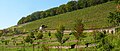 2007-10-14 Satzenberg bei Wertheim-Reicholzheim (Terrassen-Weinberg).jpg 2,481 × 1,045; 2.22 MB
-
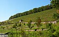 2007-10-14 Satzenberg bei Wertheim-Reicholzheim.jpg 2,500 × 1,562; 3.31 MB
-
 Blick vom Leidenrain bei Urphar ins Maintal - 1.jpg 3,264 × 1,836; 1.33 MB
-
 Blick vom Leidenrain bei Urphar ins Maintal - 2.jpg 4,128 × 2,322; 2.84 MB
-
 Wertheim 02.jpg 5,000 × 2,000; 2.83 MB
-
 Wertheim Altstadt.jpg 2,511 × 1,348; 1.4 MB
.jpg)


