Category:Lanen 2, Harlingen
Jump to navigation
Jump to search
| Object location | | View all coordinates using: OpenStreetMap |
|---|
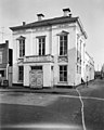
building in Harlingen, Netherlands  | |||||
| Upload media | |||||
| Instance of | |||||
|---|---|---|---|---|---|
| Location | Harlingen, Friesland, Netherlands | ||||
| Located on street | |||||
| Heritage designation |
| ||||
 | |||||
Nederlands: De Harmonie
|
This is a category about rijksmonument number 20501
|
| Address |
|
Media in category "Lanen 2, Harlingen"
The following 5 files are in this category, out of 5 total.
-
 20110409 09 Harlingen.jpg 3,648 × 2,736; 5.91 MB
-
 Exterieur OVERZICHT - Harlingen - 20291272 - RCE.jpg 1,188 × 1,200; 287 KB
-
 Exterieur OVERZICHT - Harlingen - 20291273 - RCE.jpg 1,195 × 1,200; 286 KB
-
 NUTSGEBOUW 'DE HARMONIE' - Harlingen - 20101648 - RCE.jpg 960 × 1,200; 218 KB
-
 RM20501 Harlingen - Lanen 2.jpg 2,592 × 1,944; 1.18 MB


