Category:Langgasse 119 (Haßloch)
Jump to navigation
Jump to search
| Object location | | View all coordinates using: OpenStreetMap |
|---|

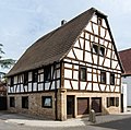
Langgasse 119 House
- In the 18th century moulded, in 1946 on the ground floor renovated house, partly timber framing, probably 16th or early 17th century.
Media in category "Langgasse 119 (Haßloch)"
The following 2 files are in this category, out of 2 total.
-
 019 2015 08 27 Kulturdenkmaeler Hassloch.jpg 2,246 × 2,225; 2.78 MB
-
 020 2015 08 27 Kulturdenkmaeler Hassloch.jpg 2,164 × 2,310; 2.42 MB

