Category:Langgasse 149 (Haßloch)
Jump to navigation
Jump to search
| Object location | | View all coordinates using: OpenStreetMap |
|---|

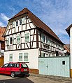
Langgasse 149 two-sided yard
- Half-timbered house, partly solid, half hipped roof, probably 1824
- streetscape formativ with No. 147
Media in category "Langgasse 149 (Haßloch)"
The following 2 files are in this category, out of 2 total.
-
 030 2015 08 27 Kulturdenkmaeler Hassloch.jpg 2,124 × 2,353; 2.63 MB
-
 031 2015 08 27 Kulturdenkmaeler Hassloch.jpg 2,074 × 2,409; 2.57 MB

