Category:Langgasse 45 (Haßloch)
Jump to navigation
Jump to search
| Object location | | View all coordinates using: OpenStreetMap |
|---|

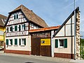
Langgasse 45 U-shaped farm
- Half hipped roof building, partly timber framing, designated 1826
- Streetscape formativ
- Brick barn, designated 1909
Media in category "Langgasse 45 (Haßloch)"
The following 4 files are in this category, out of 4 total.
-
 004 2015 08 27 Kulturdenkmaeler Hassloch.jpg 2,546 × 1,963; 2.82 MB
-
 005 2015 08 27 Kulturdenkmaeler Hassloch.jpg 2,967 × 2,234; 1.64 MB
-
 006 2015 08 27 Kulturdenkmaeler Hassloch.jpg 3,561 × 1,404; 3.57 MB
-
 Hassloch langgasse-45 20120916 680e.jpg 3,540 × 2,655; 2.62 MB


