Category:Langgasse 72 (Haßloch)
Jump to navigation
Jump to search
| Object location | | View all coordinates using: OpenStreetMap |
|---|

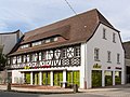
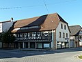
(at) Langgasse 72 Façade
- Eaves side rich half-timbered façade, late 17th or 18th century
Media in category "Langgasse 72 (Haßloch)"
The following 2 files are in this category, out of 2 total.
-
 010 2015 08 27 Kulturdenkmaeler Hassloch.jpg 2,574 × 1,941; 3.28 MB
-
 Hassloch langgasse-72 20120914 541e.jpg 3,828 × 2,872; 3.17 MB

