Category:Larvs kyrka
Jump to navigation
Jump to search
| Object location | | View all coordinates using: OpenStreetMap |
|---|
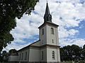
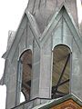
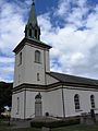
church building in Vara Municipality, Västra Götaland County, Sweden  | |||||
| Upload media | |||||
| Instance of | |||||
|---|---|---|---|---|---|
| Location | Larv, Västergötland, Västra Götaland County, Sweden | ||||
| Architectural style | |||||
| Diocese | |||||
| Architect | |||||
| Has use |
| ||||
| Occupant |
| ||||
| Heritage designation |
| ||||
| Inception |
| ||||
 | |||||
|
This is a category about an ecclesiastical monument in Sweden, number 21300000003311 in the RAÄ buildings database.
|
|
This is a category about a protected building in Sweden, number 21400000443481 in the RAÄ buildings database.
|
Media in category "Larvs kyrka"
The following 93 files are in this category, out of 93 total.
-
 Larvs kyrka - KMB - 16000200161176.jpg 822 × 600; 101 KB
-
 Larvs kyrka - KMB - 16000200161180.jpg 421 × 600; 39 KB
-
 Larvs kyrka - KMB - 16000200161182.jpg 744 × 600; 74 KB
-
 Larvs kyrka - KMB - 16000200161183.jpg 915 × 600; 75 KB
-
 Larvs kyrka - KMB - 16000200161185.jpg 775 × 600; 93 KB
-
 Larvs kyrka - KMB - 16000200161187.jpg 851 × 600; 85 KB
-
 Larvs kyrka - KMB - 16000200161189.jpg 601 × 600; 44 KB
-
 Larvs kyrka - KMB - 16000200161190.jpg 601 × 600; 77 KB
-
 Larvs kyrka - KMB - 16000200161191.jpg 604 × 600; 64 KB
-
 Larvs kyrka - KMB - 16000200161194.jpg 1,400 × 407; 129 KB
-
 Larvs kyrka - KMB - 16000200161196.jpg 1,400 × 475; 165 KB
-
 Larvs kyrka - KMB - 16000200161199.jpg 741 × 600; 78 KB
-
 Larvs kyrka - KMB - 16000200161200.jpg 809 × 600; 86 KB
-
 Larvs kyrka - KMB - 16000200161201.jpg 851 × 600; 70 KB
-
 Larvs kyrka - KMB - 16000200161202.jpg 852 × 600; 69 KB
-
 Larvs kyrka - KMB - 16000200161205.jpg 601 × 600; 61 KB
-
 Larvs kyrka - KMB - 16000200161206.jpg 603 × 600; 61 KB
-
 Larvs kyrka - KMB - 16000200161208.jpg 596 × 600; 57 KB
-
 Larvs kyrka - KMB - 16000200161211.jpg 603 × 600; 57 KB
-
 Larvs kyrka - KMB - 16000200161213.jpg 606 × 600; 60 KB
-
 Larvs kyrka - KMB - 16000200161214.jpg 605 × 600; 70 KB
-
 Larvs kyrka - KMB - 16000200161215.jpg 263 × 600; 34 KB
-
 Larvs kyrka - KMB - 16000200161216.jpg 255 × 600; 20 KB
-
 Larvs kyrka - KMB - 16000200161217.jpg 427 × 600; 42 KB
-
 Larvs kyrka - KMB - 16000200161218.jpg 754 × 600; 101 KB
-
 Larvs kyrka - KMB - 16000200161219.jpg 1,129 × 600; 226 KB
-
 Larvs kyrka - KMB - 16000200161220.jpg 838 × 600; 91 KB
-
 Larvs kyrka - KMB - 16000200161221.jpg 834 × 600; 102 KB
-
 Larvs kyrka 01.JPG 4,928 × 3,264; 3.95 MB
-
 Larvs kyrka 02.JPG 4,928 × 3,264; 3.99 MB
-
 Larvs kyrka 1888 (Ernst Wennerblad 1902).jpg 3,666 × 3,410; 12.12 MB
-
 Larvs kyrka från väster 01.jpg 4,000 × 3,000; 4.01 MB
-
 Larvs kyrka från väster 02.jpg 3,000 × 4,000; 3.45 MB
-
 Larvs kyrka från väster 03.jpg 4,000 × 3,000; 2.62 MB
-
 Larvs kyrka från väster 04.jpg 4,000 × 3,000; 2.47 MB
-
 Larvs kyrka från väster 05.jpg 4,000 × 3,000; 2.94 MB
-
 Larvs kyrka från väster 06.jpg 4,000 × 3,000; 4.38 MB
-
 Larvs kyrka från väster 07.jpg 4,000 × 3,000; 4.12 MB
-
 Larvs kyrka från väster 08.jpg 4,000 × 3,000; 1.95 MB
-
 Larvs kyrka från väster 09.jpg 3,977 × 2,983; 1.72 MB
-
 Larvs kyrka från väster 10.jpg 4,000 × 3,000; 2.18 MB
-
 Larvs kyrka från väster 11.jpg 3,000 × 4,000; 2.52 MB
-
 Larvs kyrka från väster 12.jpg 4,000 × 3,000; 2.55 MB
-
 Larvs kyrka från väster 13.jpg 3,000 × 4,000; 2.48 MB
-
 Larvs kyrka från väster 14.jpg 3,000 × 4,000; 3.81 MB
-
 Larvs kyrka från väster 15.jpg 4,000 × 3,000; 1.84 MB
-
 Larvs kyrka från väster 16.jpg 3,000 × 4,000; 2.87 MB
-
 Larvs kyrka från väster 17.jpg 3,000 × 4,000; 3.21 MB
-
 Larvs kyrka från väster 18.jpg 3,000 × 4,000; 2.97 MB
-
 Larvs kyrka från väster 19.jpg 3,000 × 4,000; 2.97 MB
-
 Larvs kyrka från väster 20.jpg 4,000 × 3,000; 2.95 MB
-
 Larvs kyrka från väster 21.jpg 4,000 × 3,000; 2.95 MB
-
 Larvs kyrka från väster 22.jpg 3,000 × 4,000; 2.06 MB
-
 Larvs kyrka från väster 23.jpg 3,000 × 4,000; 2.13 MB
-
 Larvs kyrka från väster 24.jpg 2,975 × 3,967; 1.12 MB
-
 Larvs kyrka från väster 25.jpg 3,000 × 4,000; 1.64 MB
-
 Larvs kyrka söderifrån 01.jpg 4,000 × 3,000; 2.1 MB
-
 Larvs kyrka söderifrån 02.jpg 4,000 × 3,000; 1.97 MB
-
 Larvs kyrka söderifrån 03.jpg 4,000 × 3,000; 1.94 MB
-
 Larvs kyrka söderifrån 04.jpg 4,000 × 3,000; 1.91 MB
-
 Larvs kyrka söderifrån 05.jpg 2,807 × 3,743; 1.48 MB
-
 Larvs kyrka söderifrån 06.jpg 4,000 × 3,000; 2.69 MB
-
 Larvs kyrka söderifrån 07.jpg 3,000 × 4,000; 3.34 MB
-
 Larvs kyrka söderifrån 08.jpg 3,000 × 4,000; 3.36 MB
-
 Larvs kyrka söderifrån 09.jpg 3,000 × 4,000; 3.44 MB
-
 Larvs kyrka söderifrån 10.jpg 4,000 × 3,000; 1.76 MB
-
 Larvs kyrka söderifrån 11.jpg 4,000 × 3,000; 2.01 MB
-
 Larvs kyrka söderifrån 12.jpg 4,000 × 3,000; 3.13 MB
-
 Larvs kyrka söderifrån 13.jpg 4,000 × 3,000; 2.95 MB
-
 Larvs kyrka söderifrån 14.jpg 4,000 × 3,000; 2.65 MB
-
 Larvs kyrka söderifrån 15.jpg 4,000 × 3,000; 3.65 MB
-
 Larvs kyrka söderifrån 16.jpg 4,000 × 3,000; 3.98 MB
-
 Larvs kyrka söderifrån 17.jpg 4,000 × 3,000; 4.39 MB
-
 Larvs kyrka söderifrån 18.jpg 4,000 × 3,000; 4.04 MB
-
 Larvs kyrka söderifrån 19.jpg 4,000 × 3,000; 4.47 MB
-
 Larvs kyrka söderifrån 20.jpg 4,000 × 3,000; 2.65 MB
-
 Larvs kyrka söderifrån 21.jpg 4,000 × 3,000; 3.32 MB
-
 Solur vid Larvs kyrka 01.jpg 4,000 × 3,000; 5.05 MB
-
 Solur vid Larvs kyrka 02.jpg 4,000 × 3,000; 5.04 MB
-
 Solur vid Larvs kyrka 03.jpg 4,000 × 3,000; 4.64 MB
-
 Solur vid Larvs kyrka 04.jpg 4,000 × 3,000; 4.8 MB
-
 Solur vid Larvs kyrka 05.jpg 4,000 × 3,000; 4.87 MB
-
 Solur vid Larvs kyrka 06.jpg 2,905 × 3,585; 4.11 MB
-
 Solur vid Larvs kyrka 07.jpg 3,000 × 3,682; 3.66 MB
-
 Utsikt från Larvs kyrkogård 01.jpg 3,987 × 2,991; 2.63 MB
-
 Utsikt från Larvs kyrkogård 02.jpg 4,000 × 3,000; 2.64 MB
-
 Utsikt från Larvs kyrkogård 03.jpg 3,907 × 2,931; 2.78 MB
-
 Utsikt från Larvs kyrkogård 04.jpg 3,851 × 2,889; 2.37 MB
-
 Utsikt från Larvs kyrkogård 05.jpg 3,959 × 2,969; 2.91 MB
-
 Utsikt från Larvs kyrkogård 06.jpg 4,000 × 3,000; 3.74 MB
-
 Utsikt från Larvs kyrkogård 07.jpg 3,845 × 2,885; 2.95 MB
-
 Utsikt från Larvs kyrkogård 08.jpg 4,000 × 3,000; 2.84 MB
-
 Utsikt från Larvs kyrkogård 09.jpg 4,000 × 3,000; 2.67 MB


.jpg)


Categories:
- Abraham Ludvig Hedin
- Buildings in Larv
- Built in Vara Municipality in 1865
- Churches in the Diocese of Skara
- Stone churches in Vara Municipality
- Churches in Västergötland
- Churches in Västra Götaland County built in 1865
- Larvs socken
- Neoclassical churches in Västra Götaland County
- Listed churches in Vara Municipality
- White churches in Sweden