Category:Laurierstraat 53, Amsterdam
Jump to navigation
Jump to search
| Object location | | View all coordinates using: OpenStreetMap |
|---|
house in Amsterdam, Netherlands  | |||||
| Upload media | |||||
| Instance of | |||||
|---|---|---|---|---|---|
| Location | Amsterdam, North Holland, Netherlands | ||||
| Street address |
| ||||
| Located on street | |||||
| Heritage designation |
| ||||
 | |||||
|
This is a category about rijksmonument number 3244
|
| Address |
|
Media in category "Laurierstraat 53, Amsterdam"
The following 4 files are in this category, out of 4 total.
-
 Amsterdam Laurierstraat 53 door.jpg 2,304 × 1,728; 838 KB
-
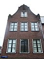 Amsterdam Laurierstraat 53 top.jpg 1,728 × 2,304; 810 KB
-
 Voor- en zijgevel - Amsterdam - 20018708 - RCE.jpg 1,177 × 1,200; 240 KB
-
 Voorgevels - Amsterdam - 20018709 - RCE.jpg 1,186 × 1,200; 287 KB


