Category:Leuchtturm Warflether Sand
Jump to navigation
Jump to search
| Object location | | View all coordinates using: OpenStreetMap |
|---|
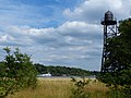
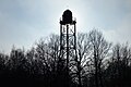
former black painted lighthouse in Lower Saxony, Germany  | |||||
| Upload media | |||||
| Instance of | |||||
|---|---|---|---|---|---|
| Made from material | |||||
| Location | Wesermarsch, Lower Saxony, Germany | ||||
| Located in or next to body of water | |||||
| Service entry |
| ||||
| Service retirement |
| ||||
| Height |
| ||||
 | |||||
Media in category "Leuchtturm Warflether Sand"
The following 8 files are in this category, out of 8 total.
-
 Schwarzer Leuchtturm Warflether Sand489.JPG 3,000 × 4,000; 4.86 MB
-
 Schwarzer Leuchtturm Warflether Sand490.JPG 3,000 × 4,000; 4.89 MB
-
 Schwarzer Leuchtturm Warflether Sand495.JPG 4,000 × 3,000; 4.74 MB
-
 Warflether Sand 6078.jpg 5,333 × 3,555; 3.97 MB
-
 Warflether Sand 6082.jpg 5,281 × 3,521; 4.38 MB
-
 Warflether Sand 6083.jpg 5,472 × 3,648; 4.08 MB
-
 Warflether Sand 6086.jpg 5,206 × 3,471; 3.87 MB
-
 Warflether Sand 6090.jpg 4,856 × 3,237; 6.09 MB


