Category:Lindengracht 17 (Sloten, Friesland)
Jump to navigation
Jump to search
| Object location | | View all coordinates using: OpenStreetMap |
|---|
 | |||||
| Upload media | |||||
| Instance of |
| ||||
|---|---|---|---|---|---|
| Location | Sloten, De Fryske Marren, Friesland, Netherlands | ||||
| Street address |
| ||||
| Located on street | |||||
| Heritage designation |
| ||||
 | |||||
|
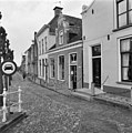
This is a category about rijksmonument number 33863
|
| Address |
|
Media in category "Lindengracht 17 (Sloten, Friesland)"
The following 11 files are in this category, out of 11 total.
-
 Overzicht - Sloten - 20201205 - RCE.jpg 1,200 × 1,195; 314 KB
-
 Overzicht - Sloten - 20346139 - RCE.jpg 1,193 × 1,200; 232 KB
-
 Overzicht Koestraat naar het oosten - Sloten - 20201085 - RCE.jpg 1,200 × 811; 235 KB
-
 Overzicht Koestraat naar het westen - Sloten - 20201083 - RCE.jpg 1,200 × 815; 209 KB
-
 Overzicht Lindengracht naar het noorden - Sloten - 20201042 - RCE.jpg 1,200 × 817; 243 KB
-
 Overzicht van de voorgevels en de westgevel van de kerk - Sloten - 20384522 - RCE.jpg 1,200 × 1,178; 230 KB
-
 Sloten Friesland 33863.JPG 2,448 × 3,264; 1.74 MB
-
 Voorgevels - Sloten - 20201202 - RCE.jpg 1,190 × 1,200; 325 KB
-
 Voorgevels - Sloten - 20201203 - RCE.jpg 1,181 × 1,200; 346 KB
-
 Voorgevels - Sloten - 20201204 - RCE.jpg 1,185 × 1,200; 320 KB
-
 Voorgevels - Sloten - 20201206 - RCE.jpg 1,185 × 1,200; 357 KB


