Category:Lingedijk 63, Wadenoijen
Jump to navigation
Jump to search
| Object location | | View all coordinates using: OpenStreetMap |
|---|
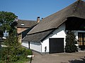
farmhouse in Tiel, Netherlands  | |||||
| Upload media | |||||
| Instance of | |||||
|---|---|---|---|---|---|
| Location | Wadenoijen, Gelderland, Netherlands | ||||
| Street address |
| ||||
| Located on street |
| ||||
| Heritage designation |
| ||||
 | |||||
|
This is a category about rijksmonument number 35623
|
| Address |
|
Media in category "Lingedijk 63, Wadenoijen"
The following 6 files are in this category, out of 6 total.
-
 Hoek Dreef - Wadenoijen - 20248683 - RCE.jpg 1,200 × 812; 219 KB
-
 Wadenoijen Lingedijk 63 1.jpg 3,264 × 2,448; 2.52 MB
-
 Wadenoijen Lingedijk 63 2.jpg 2,448 × 3,264; 2.45 MB
-
 Wadenoijen Lingedijk 63 3.jpg 3,264 × 2,448; 3.33 MB
-
 Wadenoijen Lingedijk 63 4.jpg 3,264 × 2,448; 2.53 MB
-
 Wadenoijen Lingedijk 63 5.jpg 3,264 × 2,448; 2.41 MB


