Category:Llanberis
Jump to navigation
Jump to search
village in Gwynedd, Wales  | |||||
| Upload media | |||||
| Instance of | |||||
|---|---|---|---|---|---|
| Location | Gwynedd, Wales | ||||
 | |||||
Cymraeg: Pentref mawr yng nghalon Eryri, yng Ngwynedd, yw Llanberis. Daw'r enw o sant Peris, er mai eglwys pentref cyfagos Nant Peris oedd y sefydliad gwreiddiol.
Dansk: Llanberis er en by i i Nord- Wales i grevskabet Gwynedd i nationalparken Snowdonia - faktisk ligger byen ved foden af bjerget Snowdon der har givet navn til nationalparken, og fra en station i byen udgår en smalsporsbane til bjergets top. Byen har ca. 2000 indbyggere.
Deutsch: Llanberis ist eine Ortschaft in Wales, von der die Snowdon Mountain Railway, eine Zahnradbahn zum Berg Snowdon startet.
English: Llanberis is a village in Gwynedd, North Wales, lying on the southern banks of Llyn Padarn in Snowdonia. It takes its name from Saint Peris, an early Welsh saint.
Français : Llanberis est une commune du nord du Pays de Galles, auprès du lac de Llyn Padarn du Snowdonia.
Italiano: Llanberis è un comune che si trova nella regione del Gwynedd nel nord del Galles. Nelle vicinanze c'è il lago di Llyn Padarn della Snowdonia. Ha una popolazione di 1.954 abitanti.
Polski: Llanberis - wieś turystyczna w Wielkiej Brytanii, w Walii w hrabstwie Gwynedd u podnóża Snowdonu. Ośrodek turystyki górskiej, kolarstwa górskiego o znaczeniu międzynarodowym. Dobra infrastruktura turystyczna.
Subcategories
This category has the following 18 subcategories, out of 18 total.
B
- Llanberis bomb store (26 F)
C
- Capel Hebron, Gwaun Cwm Brwynog (13 F)
- Capel Jerusalem, Llanberis (3 F)
- Ceunant Mawr Waterfall (22 F)
D
L
- Llanberis railway station (SMR) (76 F)
- Llanberis Tunnel (10 F)
- Llanberis war memorial (8 F)
- Llyn Padarn (392 F)
- Llyn Peris (82 F)
- Llyn yr Arddu (3 F)
P
- St Padarn's Church, Llanberis (25 F)
S
T
- The Pyg Track (198 F)
Media in category "Llanberis"
The following 200 files are in this category, out of 2,290 total.
(previous page) (next page)-
 "The train now approaching the sheep..." - geograph.org.uk - 4551618.jpg 640 × 480; 101 KB
-
 "View" of Crib Goch - geograph.org.uk - 5159026.jpg 640 × 360; 91 KB
-

-
 'Ty Cloc' and Gallt-y-glyn Hotel - geograph.org.uk - 330906.jpg 640 × 465; 80 KB
-

-
 2013 British Fell Relay Championships at Glyn Rhonwy - geograph.org.uk - 3707733.jpg 1,920 × 1,080; 2.43 MB
-
 20170810 Express Motors CX14 EMS.jpg 5,184 × 3,456; 7.42 MB
-
 366) Snowdonia wales.jpg 2,976 × 3,413; 1.88 MB
-
 A Bad Day on the Snowdon Mountain Railway, 1993 - geograph.org.uk - 5940806.jpg 683 × 1,024; 194 KB
-
 A bare tree (51664501239).jpg 2,250 × 2,847; 1.75 MB
-
 A barricade with a view - geograph.org.uk - 332412.jpg 640 × 480; 98 KB
-

-

-
 A boulder field - geograph.org.uk - 437221.jpg 640 × 480; 109 KB
-

-
 A boulder field on the NW slope of Y Garn - geograph.org.uk - 437233.jpg 640 × 480; 123 KB
-

-
 A col on the Cwm Ffynnon ridge - geograph.org.uk - 1768338.jpg 1,024 × 637; 228 KB
-
 A different perspective of Llanberis (50997726017).jpg 3,154 × 1,800; 2.04 MB
-
 A different view (50684871563).jpg 4,000 × 2,248; 1.79 MB
-
 A different view of Llanberis and Llyn Padarn.jpg 4,288 × 2,848; 9.49 MB
-
 A diffrent view. (40405323390).jpg 4,608 × 3,456; 6.52 MB
-
 A frozen puddle on Bryn Mawr - geograph.org.uk - 5693452.jpg 4,032 × 3,024; 4.01 MB
-
 A glacial erratic viewed against Glyder Fawr - geograph.org.uk - 1768330.jpg 1,024 × 743; 226 KB
-
 A Great Use of Local Resources - geograph.org.uk - 2711359.jpg 1,333 × 2,000; 1.3 MB
-
-
 A hesbwrn near Cadair Ellyll - geograph.org.uk - 244306.jpg 640 × 517; 112 KB
-
 A jetty beside Llyn Padarn, Llanberis - geograph.org.uk - 5331136.jpg 640 × 427; 181 KB
-

-
 A lakeside car park in Llanberis - geograph.org.uk - 3721608.jpg 800 × 591; 82 KB
-
 A lakeside path in Llanberis - geograph.org.uk - 3721613.jpg 800 × 521; 87 KB
-
 A level section of the Pyg Track - geograph.org.uk - 445691.jpg 640 × 480; 99 KB
-
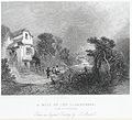
 A mill on the Llanberis - side of Snowdon.jpeg 900 × 771; 459 KB
-
 A mill on the Llanberris, side of Snowdon.jpeg 900 × 814; 446 KB
-

-
 A perched block above Pen-y-pass - geograph.org.uk - 1768249.jpg 905 × 1,024; 280 KB
-
 A SARTU Griffin over Llanberis Pass - geograph.org.uk - 268223.jpg 640 × 485; 83 KB
-
 A SARTU Griffin over mountain road - geograph.org.uk - 268220.jpg 579 × 375; 92 KB
-
 A Slate-Faced Lakeside Public Convenience - geograph.org.uk - 269252.jpg 640 × 500; 120 KB
-

-
 A step in Bryant's Gully - geograph.org.uk - 5229662.jpg 427 × 640; 75 KB
-
 A v iew of Snowden, in the vale of Llan Beriis, in Caernarvon shire.jpeg 800 × 609; 198 KB
-

-

-

-
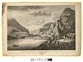 A view of Snowden, in the vale of Llan Beriis, in Caernarvon shire (1133543).jpg 1,000 × 753; 118 KB
-

-
 A walk up the Pyg track - a narrow path - geograph.org.uk - 772988.jpg 480 × 640; 205 KB
-
-

-

-
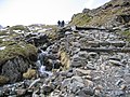
 A walk up the Pyg track - bags of rocks - geograph.org.uk - 773267.jpg 640 × 480; 222 KB
-
 A walk up the Pyg track - glaciated rocks - geograph.org.uk - 772997.jpg 640 × 480; 236 KB
-
 A walk up the Pyg track - in the snow - geograph.org.uk - 773357.jpg 640 × 480; 197 KB
-
 A walk up the Pyg track - on the level - geograph.org.uk - 772358.jpg 480 × 640; 205 KB
-

-

-
 A walk up the Pyg track - the only stiles - geograph.org.uk - 772140.jpg 640 × 480; 177 KB
-

-

-
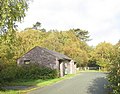
 A wall and ruined hut near Ceunant Bach - geograph.org.uk - 5548726.jpg 6,000 × 4,000; 5.05 MB
-
 A wet day at Pen-y-pass - geograph.org.uk - 3415004.jpg 1,024 × 768; 155 KB
-
 A wet September day at Pen-y-pass - geograph.org.uk - 3415000.jpg 1,024 × 802; 197 KB
-

-

-
 A4086 approaching Llanberis - geograph.org.uk - 1222017.jpg 640 × 480; 195 KB
-
 A4086 at Llanberis - geograph.org.uk - 3792310.jpg 1,600 × 1,036; 328 KB
-

-

-

-
 A4086 into Nant Peris - geograph.org.uk - 2635696.jpg 640 × 514; 67 KB
-
 A4086 towards Llanberis - geograph.org.uk - 2635685.jpg 640 × 480; 72 KB
-

-

-

-
 Abandoned section of the A4086 at Penllyn - geograph.org.uk - 2202001.jpg 1,024 × 757; 185 KB
-
 Above Bwlch y Brecan - geograph.org.uk - 5676693.jpg 1,600 × 1,200; 400 KB
-
 Above Clogwyn Coch - geograph.org.uk - 5629031.jpg 640 × 480; 100 KB
-
 Above Cwm Cywion - geograph.org.uk - 5422335.jpg 1,200 × 1,600; 458 KB
-
 Above the Llanberis Path - geograph.org.uk - 5069189.jpg 640 × 427; 62 KB
-
 Above the Llanberis Path - geograph.org.uk - 5628098.jpg 640 × 480; 90 KB
-

-
 Across the Lake (13825889275).jpg 3,074 × 1,729; 1.64 MB
-
 Afon Arddu - geograph.org.uk - 133156.jpg 640 × 427; 50 KB
-
 Afon Arddu - geograph.org.uk - 4549872.jpg 2,000 × 1,500; 635 KB
-
 Afon Arddu Valley, Snowdonia - geograph.org.uk - 2380840.jpg 1,024 × 683; 479 KB
-
 Afon Bala - geograph.org.uk - 269395.jpg 640 × 480; 105 KB
-

-
 Afon Bryn Du - geograph.org.uk - 5876856.jpg 4,000 × 3,000; 5.49 MB
-

-
 Afon Goch, Llanberis - geograph.org.uk - 3721494.jpg 800 × 728; 217 KB
-
 Afon Hwch - geograph.org.uk - 4644703.jpg 1,000 × 750; 763 KB
-
 Afon Las - geograph.org.uk - 2889795.jpg 3,872 × 2,592; 5.3 MB
-
 Afon Nant Peris - geograph.org.uk - 403975.jpg 480 × 640; 73 KB
-
 Afon Nant Peris - geograph.org.uk - 4467510.jpg 2,592 × 1,456; 1.4 MB
-
 Afon Nant Peris and A4086 - geograph.org.uk - 2635655.jpg 640 × 480; 57 KB
-

-

-

-
 Afon Nant Peris in the pass of Llanberis - geograph.org.uk - 2437836.jpg 3,264 × 2,448; 3.82 MB
-
 Afon Nant Peris towards Ynys Ettws - geograph.org.uk - 2635678.jpg 640 × 480; 116 KB
-
 Afon Nant Peris viewed downstream - geograph.org.uk - 5332466.jpg 640 × 480; 214 KB
-
 Afon Nant Peris viewed upstream - geograph.org.uk - 5332429.jpg 640 × 480; 234 KB
-
 Afon Nant-Peris at Pont Gromlech - geograph.org.uk - 2130932.jpg 1,500 × 1,000; 220 KB
-
 Afon Nant-Peris in Llanberis Pass - geograph.org.uk - 2130933.jpg 1,500 × 1,000; 189 KB
-
 Afon Nant-Peris in Llanberis Pass - geograph.org.uk - 2130942.jpg 1,500 × 1,000; 319 KB
-
 Afon Rhythallt - geograph.org.uk - 6089714.jpg 640 × 472; 68 KB
-
 Air ambulance taking off in the rain.jpg 4,275 × 2,508; 4.71 MB
-
 Albino robin near the sewage work at Llanberis - geograph.org.uk - 1992134.jpg 1,024 × 682; 161 KB
-
 All quite - (85 366) (49700929407).jpg 3,968 × 2,976; 2.12 MB
-
 Allt Pen Ceunant Hill - geograph.org.uk - 1210645.jpg 640 × 480; 77 KB
-
 Along the Pass of Llanberis - geograph.org.uk - 4198246.jpg 800 × 520; 96 KB
-
 Alpine Lodge, Llanberis - geograph.org.uk - 3721584.jpg 800 × 689; 149 KB
-
 An anti-traveller road block - geograph.org.uk - 329759.jpg 640 × 390; 65 KB
-
-
 Ancient&modern. (13881091583).jpg 3,667 × 1,560; 6.24 MB
-
 Anti-traveller measures at Glynrhonwy - geograph.org.uk - 329751.jpg 640 × 408; 98 KB
-
 Approaching Crib Goch - geograph.org.uk - 3018541.jpg 3,968 × 2,976; 2.76 MB
-
 Approaching Glyder Fawr - geograph.org.uk - 2631756.jpg 2,592 × 1,944; 1.74 MB
-
 Approaching Pen-y-Pass - geograph.org.uk - 5876378.jpg 4,000 × 3,000; 4.64 MB
-

-

-
 Approaching the road junction at Penllyn - geograph.org.uk - 2202007.jpg 1,024 × 768; 178 KB
-
Arctic charr at Llyn Padarn, Wales - torgoch yn Llyn Padarn.webm 56 s, 640 × 360; 5.16 MB
-
 Ascending the Glyder Path above Gorphwysfa - geograph.org.uk - 1768179.jpg 1,024 × 768; 242 KB
-
 Ascent of Elidir Fawr above Bwlch y Marchlyn - geograph.org.uk - 3789274.jpg 4,608 × 3,456; 5.23 MB
-
 Assorted communications - geograph.org.uk - 2635702.jpg 640 × 480; 108 KB
-
 Autogyro Above Cwm Cywion - geograph.org.uk - 4901767.jpg 1,600 × 1,200; 139 KB
-
 Autumn sunrise on Llyn Padarn.jpg 1,400 × 1,050; 939 KB
-
 Bare slopes on the south side of Glyder Fawr - geograph.org.uk - 5854850.jpg 1,469 × 1,102; 575 KB
-
 Beautiful light (51436306539).jpg 4,000 × 2,250; 1.44 MB
-
 Beautiful view. (20918922209).jpg 4,540 × 1,918; 6.21 MB
-
 Beer van (14300427710).jpg 4,320 × 3,240; 2.97 MB
-
 Below Y Garn - geograph.org.uk - 4000243.jpg 2,288 × 1,712; 850 KB
-
 Benchmark on St. John Jones Catholic Church, Llanberis - geograph.org.uk - 2810565.jpg 2,736 × 3,648; 2.53 MB
-
 Benchmark on St. Padarn's Church, Llanberis - geograph.org.uk - 2803414.jpg 2,736 × 3,648; 2.18 MB
-
 Benchmark on the A4086, Pen-y-llyn - geograph.org.uk - 2810563.jpg 2,736 × 3,648; 2.28 MB
-

-
 Benchmark on the church of St Peris, Nant Peris - geograph.org.uk - 5705347.jpg 1,200 × 1,600; 510 KB
-
 Between Llyn Peris and Llyn Padarn - geograph.org.uk - 5357945.jpg 640 × 480; 211 KB
-
 Birds above Crib y Ddysgl - geograph.org.uk - 2003485.jpg 1,024 × 747; 114 KB
-
 Black Belt Karate in Llanberis - geograph.org.uk - 3721502.jpg 800 × 578; 89 KB
-
 Blade of the giant (50363181177).jpg 2,250 × 3,192; 941 KB
-
 Blade of the giant in Llanberis. (41101812864).jpg 834 × 893; 335 KB
-
 Blaen-y-nant near to Ynys Ettws - geograph.org.uk - 2414436.jpg 3,968 × 2,976; 2.8 MB
-
 Boat on the water (4399455420).jpg 3,648 × 2,736; 4.36 MB
-
 Boats on Llyn Padarn - geograph.org.uk - 4027859.jpg 800 × 600; 143 KB
-
 Bodfan@llanberis1973.jpg 516 × 786; 55 KB
-
 Bog grass above Coed Fictoria - geograph.org.uk - 5548728.jpg 6,000 × 4,000; 5.49 MB
-
 Boulder field on the Ffridd - geograph.org.uk - 315211.jpg 640 × 480; 115 KB
-
 Boulder scree at the foot of Esgair Felen - geograph.org.uk - 445652.jpg 640 × 419; 137 KB
-
 Boulders and scree alongside the Llanberis pass - geograph.org.uk - 3044144.jpg 1,024 × 768; 194 KB
-
 Boulders beside the Pyg Track - geograph.org.uk - 3141153.jpg 640 × 480; 62 KB
-
 Boulders on steep slope - geograph.org.uk - 4381097.jpg 1,500 × 1,125; 2.16 MB
-
 Braich Mill at Dinorwig Quarry - geograph.org.uk - 3029738.jpg 640 × 427; 77 KB
-
 Braich y Foel - geograph.org.uk - 3753505.jpg 1,600 × 1,200; 626 KB
-

-
 Bridge Over Afon Goch - geograph.org.uk - 4691701.jpg 1,600 × 1,200; 830 KB
-
 Bridge over Llanberis Path, Snowdonia - geograph.org.uk - 2378781.jpg 683 × 1,024; 456 KB
-
 Bridge over the Llanberis Path - geograph.org.uk - 4155075.jpg 5,184 × 3,456; 6.18 MB
-
 Bridleway, Maesgwm - geograph.org.uk - 3742160.jpg 1,600 × 1,200; 628 KB
-
 Brithdir and Elidir Fawr - geograph.org.uk - 2253857.jpg 3,072 × 2,304; 3.25 MB
-
 Brook, near Llanberis - geograph.org.uk - 2309836.jpg 640 × 428; 139 KB
-

-
 Building remains in Dinorwic Quarry - geograph.org.uk - 4169241.jpg 4,000 × 3,000; 3.23 MB
-
 Bus shelter on the A4086 at Glynrhonwy - geograph.org.uk - 335352.jpg 640 × 480; 145 KB
-
 Bus stop at Pont Gromlech - geograph.org.uk - 2130930.jpg 1,500 × 963; 204 KB
-
 Bus stop in Llanberis - geograph.org.uk - 3480184.jpg 640 × 480; 91 KB
-
 Busy day on Crib Goch - geograph.org.uk - 4000414.jpg 1,024 × 506; 136 KB
-
 Busy morning at Halfway House - geograph.org.uk - 5069091.jpg 640 × 427; 74 KB
-
 Buttress on Garnedd Ugain - geograph.org.uk - 4167806.jpg 4,000 × 3,000; 2.48 MB
-
 Bwlch Coch - geograph.org.uk - 4167799.jpg 2,906 × 3,874; 4.08 MB
-

-
 Bwlch Cwm Brwynog from the Snowdon Ranger Path - geograph.org.uk - 2815507.jpg 2,562 × 1,813; 1.56 MB
-
 Bwlch Llanberis from the SMR - geograph.org.uk - 4153970.jpg 5,184 × 3,456; 6.06 MB
-
 Bwlch Llanberis from the SMR - geograph.org.uk - 4154020.jpg 5,184 × 3,456; 5.19 MB
-
 Bwlch Llanberis.jpeg 900 × 722; 463 KB
-
 Bwlch Y Brecan - geograph.org.uk - 4353179.jpg 2,592 × 1,944; 612 KB
-
 Bwlch y Cywion - geograph.org.uk - 2890105.jpg 3,872 × 2,592; 5.03 MB
-
 Bwlch y Ddwy-Glyder - geograph.org.uk - 3789821.jpg 4,608 × 3,456; 5.3 MB
-
 Bwlch y Marchlyn - geograph.org.uk - 3789290.jpg 4,608 × 3,456; 4.66 MB
-
 Bwlch Y Marchlyn - geograph.org.uk - 6040514.jpg 1,106 × 830; 312 KB
-
 Bwlch y Moch - geograph.org.uk - 4307858.jpg 640 × 480; 59 KB
-
 Bwlch y Moch, stile to Crib Goch - geograph.org.uk - 4167715.jpg 3,000 × 4,000; 3.54 MB
-
 C2 incline at Dinorwic Quarry - geograph.org.uk - 4169233.jpg 4,000 × 3,000; 2.46 MB
-
 C3 incline drum house, Dinorwic Quarry - geograph.org.uk - 4169264.jpg 3,904 × 2,915; 2.96 MB
-
 C3 incline drum house, Dinorwic Quarry - geograph.org.uk - 4169272.jpg 4,000 × 3,000; 3.34 MB
-
 C4 incline, Dinorwic Quarry - geograph.org.uk - 4169271.jpg 3,874 × 2,906; 3.95 MB
-
 C4 incline, Dinorwic Quarry - geograph.org.uk - 4169280.jpg 2,715 × 3,620; 4.17 MB
-
 Caban, Glynrhonwy - geograph.org.uk - 1605151.jpg 640 × 500; 110 KB
-
 Cae Newydd Gwaun Cwm Brwynog.jpg 3,769 × 2,827; 6.38 MB
-
 Cae Newydd, Gwaun Cwm Brwynog.jpg 3,969 × 2,977; 3.24 MB
-
 Caenant Mawr, near Llanberis.jpeg 900 × 713; 414 KB
-
 Caenant Mawr, near Llanberris.jpeg 900 × 635; 299 KB
-
 Caennant Mawr, Llanberris (1132025).jpg 1,000 × 847; 207 KB
-
 Caennant Mawr, Llanberris.jpeg 900 × 734; 411 KB
-
 Caernarfon 7 - geograph.org.uk - 4951482.jpg 1,024 × 683; 238 KB
-
 Caernarfon 8 - geograph.org.uk - 4304505.jpg 1,024 × 683; 170 KB
-
 Cairn new Clogwyn Station - geograph.org.uk - 2378386.jpg 1,024 × 682; 194 KB
-
 Cairn on Clogwyn Du'r Arddu - geograph.org.uk - 4600250.jpg 1,024 × 680; 251 KB


_Snowdonia_wales.jpg)

.jpg)


.jpg)
.jpg)

.jpg)


.jpg)


.jpg)


_(49700929407).jpg)


.jpg)


.jpg)
.jpg)
.jpg)


.jpg)
.jpg)

.jpg)


.jpg)


