Category:Llandyfriog
Jump to navigation
Jump to search

village and community in Ceredigion, Wales  | |||||
| Upload media | |||||
| Instance of | |||||
|---|---|---|---|---|---|
| Location | Ceredigion, Wales | ||||
| Population |
| ||||
| Area |
| ||||
 | |||||
Subcategories
This category has the following 7 subcategories, out of 7 total.
Media in category "Llandyfriog"
The following 181 files are in this category, out of 181 total.
-

-
 20 sign, Coedmore Lane, Adpar, Ceredigion - geograph.org.uk - 6217314.jpg 1,600 × 1,507; 541 KB
-
 A475 and B4334 junction - geograph.org.uk - 2644475.jpg 3,482 × 2,615; 1.4 MB
-
 A475 passes through Llandyfriog - geograph.org.uk - 2645076.jpg 3,526 × 2,672; 1.19 MB
-
 A475 southeast of Llandyfriog - geograph.org.uk - 2645064.jpg 3,471 × 2,516; 1.67 MB
-
 A475, Penrhiw-Llan - geograph.org.uk - 2086021.jpg 640 × 482; 73 KB
-
 Aber-banc, junction of B4334 and A475 - geograph.org.uk - 4126492.jpg 4,320 × 3,240; 2.98 MB
-
 Adpar Building Supplies, Adpar, Ceredigion - geograph.org.uk - 6212249.jpg 1,600 × 1,073; 295 KB
-
 Afon Teifi - Teifi River - geograph.org.uk - 5724433.jpg 640 × 480; 113 KB
-
 Afon Teifi above Castell Newydd-Emlyn - geograph.org.uk - 2645098.jpg 3,648 × 2,736; 3.05 MB
-
 Alien invader in Castle Meadow - geograph.org.uk - 923019.jpg 640 × 480; 130 KB
-
 Alley behind Teifi Terrace, Adpar - geograph.org.uk - 4660141.jpg 2,560 × 1,920; 2.62 MB
-
 B4333 from Adpar towards Aberporth - geograph.org.uk - 6217401.jpg 1,600 × 1,203; 362 KB
-
 B4333 is Lloyd Terrace in Adpar - geograph.org.uk - 2681804.jpg 3,058 × 2,213; 1.13 MB
-
 B4571, Bryndioddef - geograph.org.uk - 2117876.jpg 640 × 480; 75 KB
-
 Banc-lâs, Cwmceri - geograph.org.uk - 2990456.jpg 1,600 × 1,145; 740 KB
-
 Beef Cattle - geograph.org.uk - 1381560.jpg 640 × 482; 63 KB
-
 Bend in the River Teifi - geograph.org.uk - 4659760.jpg 2,560 × 1,898; 3.08 MB
-
 Bends in the Teifi, Newcastle Emlyn - geograph.org.uk - 4810963.jpg 2,560 × 1,892; 2.98 MB
-
 Blaenant - geograph.org.uk - 919405.jpg 640 × 475; 92 KB
-
 Boarded-up Riverside Health shop in Adpar, Ceredigion - geograph.org.uk - 6210382.jpg 1,530 × 1,600; 533 KB
-
 Bridge over the Nant Gwylan, on the B4334 - geograph.org.uk - 4126496.jpg 4,320 × 3,240; 2.99 MB
-
 Bridgend House, Adpar, Ceredigion - geograph.org.uk - 6233221.jpg 1,582 × 1,600; 367 KB
-
 Bronorwen, Llandyfrïog - geograph.org.uk - 991646.jpg 505 × 640; 74 KB
-
 Bryndioddef-Hill of suffering - geograph.org.uk - 919376.jpg 640 × 480; 66 KB
-

-
 Bungalows alongside the B4333, Adpar, Ceredigion - geograph.org.uk - 6233141.jpg 1,600 × 1,110; 309 KB
-
-
 Chapel - geograph.org.uk - 344862.jpg 640 × 480; 114 KB
-
 China Kitchen in Adpar, Ceredigion - geograph.org.uk - 6210404.jpg 1,503 × 1,600; 382 KB
-
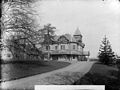
 Cilgwyn Hall, Llandyfriog NLW3361301.jpg 595 × 448; 69 KB
-
 Cilgwyn Hall, Llandyfriog NLW3361303.jpg 599 × 451; 66 KB
-
 Cilgwyn Hall, Newcastle Emlyn NLW3362999.jpg 601 × 429; 68 KB
-
 Coedmore Lane bilingual name sign, Adpar, Ceredigion - geograph.org.uk - 6210445.jpg 1,600 × 1,214; 485 KB
-
 Coedmore Lane, Adpar, Ceredigion - geograph.org.uk - 6210442.jpg 1,207 × 1,600; 358 KB
-
 Concrete road to Trecagal - geograph.org.uk - 1344766.jpg 629 × 640; 65 KB
-
 Converted mill, Adpar - geograph.org.uk - 4269192.jpg 2,560 × 1,901; 2.5 MB
-
 Cormorant beside the Teifi, Adpar - geograph.org.uk - 4659833.jpg 2,560 × 1,920; 2.82 MB
-
 Cottage in Adpar - geograph.org.uk - 2358101.jpg 640 × 480; 88 KB
-
 Cottage once a pub - geograph.org.uk - 920328.jpg 640 × 480; 71 KB
-
 Country View - geograph.org.uk - 1381582.jpg 640 × 482; 72 KB
-
 Croeso Care Ltd, Adpar, Ceredigion - geograph.org.uk - 6210368.jpg 1,600 × 1,189; 397 KB
-
 Cumulus to the west - geograph.org.uk - 920253.jpg 640 × 480; 48 KB
-
 Cwm Ceri to the northeast - geograph.org.uk - 920411.jpg 640 × 480; 81 KB
-
 Cwm Ceri, looking northwest - geograph.org.uk - 920415.jpg 640 × 480; 96 KB
-
 Cwrycoed - geograph.org.uk - 5724365.jpg 640 × 480; 84 KB
-

-
 Descent from Adpar towards Newcastle Emlyn - geograph.org.uk - 6217261.jpg 1,600 × 1,379; 435 KB
-

-

-
 Directions sign alongside the B4333, Adpar, Ceredigion - geograph.org.uk - 6233098.jpg 1,600 × 1,485; 385 KB
-
 Directions sign alongside the B4571, Adpar, Ceredigion - geograph.org.uk - 6217230.jpg 1,162 × 1,600; 391 KB
-
 Disused leet, Adpar - geograph.org.uk - 4269215.jpg 2,560 × 1,886; 2.93 MB
-
 East end of Teifi Terrace, Adpar - geograph.org.uk - 4660126.jpg 2,560 × 1,917; 2.4 MB
-
 East side of Newcastle Emlyn Bridge - geograph.org.uk - 6225265.jpg 1,600 × 1,200; 566 KB
-
 Emlyn Launderette, Adpar, Ceredigion - geograph.org.uk - 6210411.jpg 1,600 × 1,578; 482 KB
-
 Entrance to Old Cilgwyn - geograph.org.uk - 919397.jpg 640 × 480; 97 KB
-
 Entrance to the village of Llandyfrïog - geograph.org.uk - 991655.jpg 640 × 471; 168 KB
-
 Faded mini-roundabout on the approach to Newcastle Emlyn - geograph.org.uk - 6217576.jpg 1,600 × 1,289; 415 KB
-
 Farm track near Blaen-Cil-Llech - geograph.org.uk - 5072914.jpg 4,608 × 3,456; 4 MB
-
 Farm track near Blaen-Cil-Llech - geograph.org.uk - 5072922.jpg 4,608 × 3,456; 3.85 MB
-
 Fenced-off area, Lloyds Terrace, Adpar, Ceredigion - geograph.org.uk - 6212263.jpg 1,600 × 1,202; 334 KB
-
 Field next to Nant Iago - geograph.org.uk - 1344758.jpg 591 × 640; 174 KB
-
 Footbridge from Carmarthenshire to Ceredigion - geograph.org.uk - 6238578.jpg 1,600 × 1,164; 354 KB
-
 Footpath alongside Afon Cwm-wern - geograph.org.uk - 1344740.jpg 600 × 640; 180 KB
-
 Footpath junction above Llandyfriog - geograph.org.uk - 1344725.jpg 640 × 480; 136 KB
-
 For Sale sign alongside the B4333, Adpar, Ceredigion - geograph.org.uk - 6233200.jpg 1,600 × 1,553; 500 KB
-
 Former Drovers Arms pub, Adpar, Ceredigion - geograph.org.uk - 6217304.jpg 1,600 × 1,216; 367 KB
-
 From 30 to 20 on the B4333, Adpar, Ceredigion - geograph.org.uk - 6233190.jpg 1,597 × 1,578; 427 KB
-
 Ger Gilfachronw - Near Gilfachronw - geograph.org.uk - 5724310.jpg 640 × 480; 140 KB
-

-

-
 Hedgeline and Shadow Frost at Pen Allt Triangulation Pillar - geograph.org.uk - 4750297.jpg 4,000 × 3,000; 3.04 MB
-
 Henllan Falls - geograph.org.uk - 4608711.jpg 2,560 × 1,920; 2.57 MB
-
 Henllan Station, Teifi Valley Railway - geograph.org.uk - 6225876.jpg 1,280 × 851; 462 KB
-
 Heol y Merwydd, Penrhiwllan - geograph.org.uk - 6225833.jpg 1,280 × 851; 405 KB
-
 Houses above Lloyds Terrace, Adpar, Ceredigion - geograph.org.uk - 6233115.jpg 1,600 × 1,200; 324 KB
-
 Houses alongside the A475 in Adpar, Ceredigion - geograph.org.uk - 6233230.jpg 1,600 × 1,200; 405 KB
-

-
 Houses alongside the B4571, Adpar, Ceredigion - geograph.org.uk - 6210384.jpg 1,600 × 1,410; 370 KB
-
 Houses near Adpar Bridge - geograph.org.uk - 3712786.jpg 2,560 × 1,838; 2.2 MB
-
 Ildiwch-Give Way sign on an Adpar corner, Ceredigion - geograph.org.uk - 6233107.jpg 1,600 × 1,262; 360 KB
-

-
 Lane near Argoed, Llanfair Treflygen - geograph.org.uk - 991640.jpg 640 × 480; 94 KB
-
 Lane to Croes-lan - geograph.org.uk - 6225826.jpg 1,280 × 851; 471 KB
-
 Llandyfriog Community Hall - geograph.org.uk - 708510.jpg 640 × 482; 105 KB
-
 Lloyds Terrace houses, Adpar, Ceredigion - geograph.org.uk - 6233150.jpg 1,600 × 1,200; 325 KB
-

-

-

-
 Llwybr ger Pantdafydd - Path near Pantdafydd - geograph.org.uk - 6152482.jpg 1,024 × 767; 421 KB
-
 Llwybr Trecagal - Trecagal Path - geograph.org.uk - 5724272.jpg 640 × 480; 78 KB
-

-
 Looking west-southwest along the A475 - geograph.org.uk - 4421049.jpg 1,044 × 783; 236 KB
-
 Meadow on the Teifi, Llandyfrïog - geograph.org.uk - 828420.jpg 640 × 480; 127 KB
-

-
 Milestone - Cardigan 10 - geograph.org.uk - 4461935.jpg 480 × 640; 121 KB
-
 Milestone - Cardigan 9 - geograph.org.uk - 4461923.jpg 480 × 640; 125 KB
-
 Milestone at Llandyfriog - geograph.org.uk - 925236.jpg 640 × 480; 126 KB
-
 Milestone with benchmark, Adpar - geograph.org.uk - 4269198.jpg 2,560 × 1,920; 2.97 MB
-
 Milestone, Penrhiw-Llan - geograph.org.uk - 2086010.jpg 480 × 640; 87 KB
-
 Muddy track to Allt Llwyn-Cadfer - geograph.org.uk - 1344729.jpg 595 × 640; 168 KB
-

-

-

-
 Old Milestone by the A475, Llandyfriog - geograph.org.uk - 6098930.jpg 600 × 800; 176 KB
-

-

-
-

-
 Parkland - geograph.org.uk - 920333.jpg 640 × 480; 72 KB
-
 Pasture, Ffynnon-Fair, Llanfair Treflygen - geograph.org.uk - 997927.jpg 640 × 480; 101 KB
-
 Penrhiwllan Stores - geograph.org.uk - 6225856.jpg 1,280 × 851; 411 KB
-
 Phone box at Llandyfriog - geograph.org.uk - 922351.jpg 640 × 480; 76 KB
-
 Pink and yellow alongside the B4571, Adpar, Ceredigion - geograph.org.uk - 6217619.jpg 1,600 × 1,372; 352 KB
-

-
 Pwll Cornel Isaf - geograph.org.uk - 6270204.jpg 1,024 × 768; 230 KB
-

-

-
 Railway bridge^ - geograph.org.uk - 2254606.jpg 2,048 × 1,536; 645 KB
-
 Red Cow name sign, Adpar, Ceredigion - geograph.org.uk - 6210432.jpg 470 × 640; 96 KB
-
 Redevelopment near Adpar - geograph.org.uk - 2358086.jpg 640 × 480; 74 KB
-
 Rhyd Afon Cwerchyr - Afon Cwerchyr ford - geograph.org.uk - 6270196.jpg 1,024 × 683; 347 KB
-
 Riverbank part of the A475, Adpar, Ceredigion - geograph.org.uk - 6225280.jpg 1,600 × 1,365; 530 KB
-
 Riverside Coffee Shop ^ Cafe, Adpar, Ceredigion - geograph.org.uk - 6225277.jpg 1,600 × 1,336; 557 KB
-
 Road bridge across the Teifi, Henllan - geograph.org.uk - 4126491.jpg 4,320 × 3,240; 3.05 MB
-

-
 Road junction at Blaen-Cil-Llech - geograph.org.uk - 3555019.jpg 640 × 458; 56 KB
-

-
 Sheep and lambs in Adpar - geograph.org.uk - 2358096.jpg 640 × 480; 106 KB
-
 Side road to Teifi Terrace, Adpar, Ceredigion - geograph.org.uk - 6233207.jpg 1,345 × 1,600; 414 KB
-
 Southern boundary sign, Ceredigion - geograph.org.uk - 6233239.jpg 904 × 1,467; 310 KB
-
 Stone houses alongside the B4571, Adpar, Ceredigion - geograph.org.uk - 6217595.jpg 1,600 × 1,248; 435 KB
-
 Stone houses, Coedmore Lane, Adpar, Ceredigion - geograph.org.uk - 6217311.jpg 785 × 1,024; 206 KB
-

-
 Super Garden, Red Cow, Adpar, Ceredigion - geograph.org.uk - 6210424.jpg 1,600 × 1,125; 350 KB
-
 Sussex House, Lloyds Terrace, Adpar, Ceredigion - geograph.org.uk - 6212256.jpg 1,600 × 1,376; 347 KB
-
 Teifi Terrace, Adpar - geograph.org.uk - 4659874.jpg 2,560 × 1,918; 2.91 MB
-
 Teifi Terrace, Adpar, Ceredigion - geograph.org.uk - 6217355.jpg 1,506 × 1,600; 680 KB
-
 Teifi Terrace, Adpar, Ceredigion - geograph.org.uk - 6233241.jpg 1,600 × 1,134; 291 KB
-
 Teifi Valley Railway - geograph.org.uk - 4840706.jpg 640 × 427; 186 KB
-
 Teifi Valley Railway direction sign, Adpar, Ceredigion - geograph.org.uk - 6225281.jpg 1,600 × 1,535; 780 KB
-
 Teras Teifi-Teifi Terrace name sign, Adpar, Ceredigion - geograph.org.uk - 6217356.jpg 1,600 × 1,277; 451 KB
-
 The 11-30 express is about to depart - geograph.org.uk - 2560058.jpg 640 × 467; 151 KB
-
 The A475 through Penrhiw-llan - geograph.org.uk - 4421030.jpg 946 × 709; 180 KB
-
 The Afon Teifi from Pont Allt-y-cafn, Pentre Cwrt - geograph.org.uk - 6138213.jpg 2,000 × 1,500; 938 KB
-
 The B4571 just south of Blaen-Cil-Llech - geograph.org.uk - 5072939.jpg 4,608 × 3,456; 3.86 MB
-
 The B4571 just south of Blaen-Cil-Llech - geograph.org.uk - 5072943.jpg 4,608 × 3,456; 3.83 MB
-
 The bridge, Newcastle Emlyn - geograph.org.uk - 5074138.jpg 4,608 × 3,456; 4.01 MB
-
 The Daffodil from its car park - geograph.org.uk - 2644452.jpg 3,648 × 2,736; 1.34 MB
-
 The Daffodil Inn, Penrhiwllan - geograph.org.uk - 6225757.jpg 1,280 × 851; 386 KB
-
 The guardian of the footpath - geograph.org.uk - 922320.jpg 640 × 480; 147 KB
-
 The mill dam, Newcastle Emlyn - geograph.org.uk - 3712705.jpg 2,560 × 1,885; 2.17 MB
-
 The Nant Gwylan near Aber-banc - geograph.org.uk - 4126498.jpg 4,320 × 3,240; 3.01 MB
-
 The terrace at the Daffodil Inn, Penrhiwllan - geograph.org.uk - 6225849.jpg 1,280 × 851; 506 KB
-
 The view towards Old Cilgwyn - geograph.org.uk - 920312.jpg 640 × 480; 77 KB
-
 Three-way bridge at Old Cilgwyn - geograph.org.uk - 920347.jpg 640 × 480; 139 KB
-
 Track to Ffynnon-Fair, Llanfair Treflygen - geograph.org.uk - 997931.jpg 640 × 474; 131 KB
-

-
 Tree bole clenching stone - geograph.org.uk - 921878.jpg 480 × 640; 118 KB
-
 Tuag at Aberbanc - Towards Aberbanc - geograph.org.uk - 5724451.jpg 640 × 480; 84 KB
-
 Tuag at Gwrycoed - Towards Cwrycoed - geograph.org.uk - 5724383.jpg 640 × 480; 98 KB
-
 Unnamed side road, Adpar, Ceredigion - geograph.org.uk - 6217606.jpg 1,600 × 1,108; 361 KB
-
 Up the B4571, Adpar, Ceredigion - geograph.org.uk - 6217218.jpg 1,600 × 1,504; 652 KB
-
 Upper Llandyfriog - geograph.org.uk - 1381600.jpg 640 × 463; 74 KB
-
 Wales Ceredigion Community Llandyfriog map.svg 512 × 428; 788 KB
-

-

-

-
 Welsh Slate and Gorse - geograph.org.uk - 344034.jpg 640 × 480; 186 KB
-
 Western end of Coedmore Lane, Adpar, Ceredigion - geograph.org.uk - 6217318.jpg 1,277 × 1,600; 590 KB
-
 Western end of Llandyfriog - geograph.org.uk - 921897.jpg 640 × 480; 81 KB
-
 White houses alongside the B4571, Adpar, Ceredigion - geograph.org.uk - 6217589.jpg 1,600 × 1,339; 410 KB
-
 Wind turbine - geograph.org.uk - 4833941.jpg 2,048 × 1,536; 616 KB
-
 Wind turbine - geograph.org.uk - 4833947.jpg 2,048 × 1,536; 590 KB
-
 Wind turbine behind winter hedge - geograph.org.uk - 4833937.jpg 2,048 × 1,536; 648 KB
-
 Winter's afternoon - geograph.org.uk - 892084.jpg 640 × 425; 46 KB
-
 WNW along the B4333, Adpar, Ceredigion - geograph.org.uk - 6212274.jpg 1,485 × 1,600; 371 KB
-
 Wooden bench, Lloyds Terrace, Adpar, Ceredigion - geograph.org.uk - 6212270.jpg 1,600 × 1,037; 344 KB
-
 Y Fuwch Goch, Adpar - geograph.org.uk - 3712765.jpg 2,560 × 1,944; 1.96 MB
-
 Ye Olde Drovers date sign - geograph.org.uk - 919967.jpg 640 × 480; 82 KB
_Tunnel_Brake_Van,_Teifi_Valley_Railway,_Henllan_Station_-_geograph.org.uk_-_4394831.jpg)


_and_B4333_(to_Aberporth),_Newcastle_Emlyn_-_geograph.org.uk_-_5074168.jpg)


