Category:Llangynhafal
Jump to navigation
Jump to search
village in Denbighshire, Wales _01.jpg) | |||||
| Upload media | |||||
| Instance of | |||||
|---|---|---|---|---|---|
| Location | Denbighshire, Wales | ||||
| Population |
| ||||
| Area |
| ||||
 | |||||
Subcategories
This category has the following 6 subcategories, out of 6 total.
Media in category "Llangynhafal"
The following 200 files are in this category, out of 211 total.
(previous page) (next page)-

-
 A bit of history in a grazing field - geograph.org.uk - 4662060.jpg 3,264 × 2,448; 3.51 MB
-

-
 A nasty accident^ - geograph.org.uk - 4675476.jpg 3,384 × 4,154; 2.02 MB
-
 A rare sight - geograph.org.uk - 2917549.jpg 640 × 480; 80 KB
-
 Approaching Gellifor from the north - geograph.org.uk - 2917640.jpg 480 × 640; 101 KB
-
 Approaching the Jubilee Tower - geograph.org.uk - 615030.jpg 640 × 480; 57 KB
-

-

-

-

-
-

-

-

-

-
-

-

-

-

-

-

-

-

-

-

-
 Bridleway leading to Gellifor - geograph.org.uk - 4662158.jpg 3,264 × 2,448; 6.18 MB
-
 Bryn-bedw - geograph.org.uk - 4675088.jpg 5,184 × 2,596; 1.55 MB
-
 Bryn-bedw - geograph.org.uk - 4675136.jpg 5,123 × 2,909; 1.65 MB
-
 Bryniau Clwyd - Clwydian Range - geograph.org.uk - 3956785.jpg 640 × 480; 84 KB
-
 Bryniau Clwyd - geograph.org.uk - 4277666.jpg 1,600 × 1,200; 448 KB
-
 Burnt heather on the slopes of Moel Llys-y-coed - geograph.org.uk - 6153478.jpg 1,024 × 683; 143 KB
-
 Cairn On Moel Dywyll - geograph.org.uk - 4277662.jpg 1,600 × 1,200; 329 KB
-
 Cairn on Moel Dywyll - geograph.org.uk - 6596767.jpg 4,000 × 3,000; 3.02 MB
-

-
 Clwyd Hall Lodge - geograph.org.uk - 2917565.jpg 640 × 480; 80 KB
-
 Clwyd Hall, Llanychan - geograph.org.uk - 6507643.jpg 3,264 × 2,448; 1.2 MB
-
 Cottage garden in Gellifor - geograph.org.uk - 2917512.jpg 640 × 480; 146 KB
-
 Cottages at Star Farm - geograph.org.uk - 135330.jpg 640 × 407; 53 KB
-

-
 Farm road to Plas Dolben - geograph.org.uk - 1042189.jpg 640 × 480; 119 KB
-
 Farm road to Plas Llanychan - geograph.org.uk - 5720577.jpg 640 × 480; 74 KB
-
 Footpath and stile near Llangynhafal - geograph.org.uk - 1042185.jpg 480 × 640; 74 KB
-
 Footpath and track to Llanynys - geograph.org.uk - 1844812.jpg 640 × 480; 101 KB
-
 Footpath to Moel Arthur - geograph.org.uk - 1171826.jpg 640 × 480; 159 KB
-
 Footpath to Moel Arthur Car-park - geograph.org.uk - 1171821.jpg 640 × 480; 120 KB
-
 Footpath to Moel Arthur Car-park - geograph.org.uk - 1171822.jpg 640 × 480; 111 KB
-
 Footpaths in the pass - geograph.org.uk - 2230476.jpg 640 × 480; 84 KB
-
 Gateway and track below Moel Dywyll - geograph.org.uk - 6011034.jpg 1,600 × 1,200; 494 KB
-
 Gateway entrance to Plas Isaf - geograph.org.uk - 1042357.jpg 640 × 480; 156 KB
-
 Glorious heather clad hillside - geograph.org.uk - 4662173.jpg 3,264 × 2,448; 7.25 MB
-
 Golden Lion, Llangynhafal - geograph.org.uk - 1042198.jpg 640 × 480; 65 KB
-

-

-

-
 Hedge lined minor road at Llidiat Farm - geograph.org.uk - 5986269.jpg 4,000 × 3,000; 3.65 MB
-
 Hedge lined minor road at Ty Coch - geograph.org.uk - 5986257.jpg 4,000 × 3,000; 3.33 MB
-
 Hereford cattle at Plas Coch farm - geograph.org.uk - 1844814.jpg 640 × 494; 75 KB
-
 Hirwaen - geograph.org.uk - 218628.jpg 640 × 480; 83 KB
-

-
 House in the country - geograph.org.uk - 5720582.jpg 640 × 480; 82 KB
-
 Hungry Sheep at Llangwyfan - geograph.org.uk - 337693.jpg 640 × 480; 201 KB
-
 Industrial Archeology - geograph.org.uk - 4675093.jpg 5,184 × 2,821; 1.69 MB
-
 Information board regarding the nearby concrete structure - geograph.org.uk - 4662127.jpg 3,264 × 2,448; 3.64 MB
-
 Jubilee Tower, Moel Famau - geograph.org.uk - 3645130.jpg 6,888 × 4,592; 5.26 MB
-
 Jubilee Tower, Moel Famau - geograph.org.uk - 4277675.jpg 1,600 × 1,200; 362 KB
-
 Jubilee Tower, Moel Famau - geograph.org.uk - 6153221.jpg 1,024 × 683; 150 KB
-
 Jubilee Tower, Moel Famau. - geograph.org.uk - 2330470.jpg 640 × 480; 58 KB
-
 Little Grey Fergie - geograph.org.uk - 4675080.jpg 5,119 × 3,157; 1.93 MB
-
 Llangynhafal - geograph.org.uk - 4675489.jpg 5,184 × 3,456; 1.7 MB
-
 Llangynhafal - geograph.org.uk - 4675491.jpg 5,184 × 2,586; 1.68 MB
-
 Llanychan Sewage Treatment works - geograph.org.uk - 2917577.jpg 640 × 480; 59 KB
-
 Llethrau Moel Dywyll - geograph.org.uk - 3957143.jpg 640 × 480; 65 KB
-
 Llidiart Fawr - geograph.org.uk - 2284440.jpg 640 × 480; 81 KB
-
 Looking towards Moel Famau on the Offa's Dyke Path - geograph.org.uk - 6596364.jpg 4,000 × 3,000; 2.64 MB
-
 Maes Hafal, Gellifor - geograph.org.uk - 2917510.jpg 640 × 480; 74 KB
-
 Memorial Stone near Llangwyfan ^1 - geograph.org.uk - 343559.jpg 640 × 480; 239 KB
-
 Memorial Stone near Llangwyfan ^2 - geograph.org.uk - 343574.jpg 640 × 480; 202 KB
-
 Memorial Stone near Llangwyfan ^3 - geograph.org.uk - 343578.jpg 640 × 480; 213 KB
-
 Minor road at Star Farm - geograph.org.uk - 5986263.jpg 4,000 × 3,000; 3.17 MB
-
 Moel Arthur - geograph.org.uk - 3060806.jpg 1,600 × 1,200; 248 KB
-
 Moel Arthur hill fort - geograph.org.uk - 3253020.jpg 3,008 × 2,000; 834 KB
-
 Moel Dywyll - geograph.org.uk - 6354866.jpg 3,264 × 2,448; 1.01 MB
-
 Moel Famau - geograph.org.uk - 5578262.jpg 5,184 × 3,456; 4.18 MB
-
 Moel Famau Country Park - geograph.org.uk - 1723608.jpg 640 × 463; 78 KB
-
 Moel Famau Country Park - geograph.org.uk - 3036522.jpg 6,888 × 4,592; 3.3 MB
-
 Moel Famau Jubilee Tower in snow - geograph.org.uk - 3300412.jpg 4,320 × 3,240; 5.26 MB
-
 Moel y Gaer - geograph.org.uk - 615021.jpg 640 × 480; 49 KB
-
 Moel y Gaer Hill Fort as seen from Moel Famau - geograph.org.uk - 6460088.jpg 1,799 × 1,199; 450 KB
-
 Moorland below Pwll y Rhos - geograph.org.uk - 310787.jpg 640 × 480; 206 KB
-
 Offa's Dyke approaching a path junction - geograph.org.uk - 6153268.jpg 1,024 × 683; 159 KB
-
 Offa's Dyke at Moel Dywyll - geograph.org.uk - 5575787.jpg 5,184 × 3,456; 3.3 MB
-
 Offa's Dyke Path - geograph.org.uk - 3253026.jpg 3,008 × 2,000; 823 KB
-
 Offa's Dyke path - geograph.org.uk - 6153258.jpg 1,024 × 683; 169 KB
-
 Offa's Dyke Path - geograph.org.uk - 6596365.jpg 4,000 × 3,000; 2.94 MB
-
 Offa's Dyke Path - geograph.org.uk - 6596771.jpg 4,000 × 3,000; 2.8 MB
-
 Offa's Dyke Path - geograph.org.uk - 6596776.jpg 4,000 × 3,000; 2.57 MB
-
 Offa's Dyke path and view to Moel Dywyll - geograph.org.uk - 6153264.jpg 1,024 × 683; 174 KB
-
 Offa's Dyke Path approaching Moel Dywyll - geograph.org.uk - 5574357.jpg 5,184 × 3,456; 3.35 MB
-
 Offa's Dyke path approaching Moel Dywyll - geograph.org.uk - 6153460.jpg 1,024 × 683; 162 KB
-
-
 Offa's Dyke Path near Moel Llys-y-coed - geograph.org.uk - 5572321.jpg 5,184 × 3,456; 2.33 MB
-
 Offa's Dyke Path near Penycloddiau - geograph.org.uk - 616206.jpg 640 × 480; 107 KB
-
 Offa's Dyke path on Moel Dywyll - geograph.org.uk - 6153467.jpg 1,024 × 683; 165 KB
-
 Offa's Dyke Path on Moel Famau - geograph.org.uk - 3036516.jpg 3,888 × 2,592; 2.15 MB
-
 Offa's Dyke path on Moel Famau - geograph.org.uk - 6153239.jpg 1,024 × 683; 139 KB
-
 Offa's Dyke Path on Moel Llys y Coed - geograph.org.uk - 6576140.jpg 3,797 × 2,847; 2.46 MB
-
 Offa's Dyke Path on Moel Llys y Coed - geograph.org.uk - 6577681.jpg 4,000 × 3,000; 2.93 MB
-
 Offa's Dyke path on the ridge of Moel Dywyll - geograph.org.uk - 6153462.jpg 1,024 × 683; 138 KB
-
 Offa's Dyke Path signpost - geograph.org.uk - 6577691.jpg 4,000 × 3,000; 2.95 MB
-
 Offa's Dyke Path towards Moel Arthur - geograph.org.uk - 5572315.jpg 5,184 × 3,456; 2.33 MB
-
 Offa's Dyke Path towards Moel Dywyll - geograph.org.uk - 5577992.jpg 5,184 × 3,456; 3.09 MB
-
 Offa's Dyke Path towards Moel Famau - geograph.org.uk - 5574351.jpg 5,184 × 3,456; 3.67 MB
-

-

-
 Old School, Llangynhafal - geograph.org.uk - 1042191.jpg 640 × 480; 62 KB
-

-
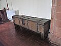 Parish Chest, Llangynhafal church - geograph.org.uk - 6054045.jpg 4,000 × 3,000; 2.74 MB
-
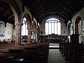
 Parish Church of St Cynhafal - geograph.org.uk - 6054041.jpg 4,000 × 3,000; 2.44 MB
-
 Pentre - geograph.org.uk - 4675031.jpg 5,184 × 3,456; 1.68 MB
-
 Pentre Farm - geograph.org.uk - 4675475.jpg 5,184 × 2,924; 1.95 MB
-
 Plas Draw - geograph.org.uk - 4675090.jpg 5,133 × 2,790; 1.91 MB
-

-
 Plas-yn-Rhos Farm - geograph.org.uk - 2917546.jpg 640 × 480; 78 KB
-
 Post box at Plas Draw - geograph.org.uk - 2284566.jpg 640 × 480; 153 KB
-
 Ram at Ty Coch Farm - geograph.org.uk - 6354869.jpg 3,264 × 2,448; 1.52 MB
-
 Refurbished barn at Ty Coch, Llangynhafal - geograph.org.uk - 6354862.jpg 3,264 × 2,448; 2.2 MB
-
 Reservoir below Moel Dywyll - geograph.org.uk - 6596363.jpg 4,000 × 3,000; 2.85 MB
-
 Rhos Farm, near Gellifor - geograph.org.uk - 2917553.jpg 640 × 478; 57 KB
-
 Rivet bench mark below Moel Dywyll - geograph.org.uk - 6011025.jpg 1,200 × 1,600; 722 KB
-
 Road towards Moel Arthur - geograph.org.uk - 1171823.jpg 640 × 480; 125 KB
-
 Rock beside the Offa's Dyke path - geograph.org.uk - 6153473.jpg 1,024 × 683; 163 KB
-
 Ruins of Farm Building. - geograph.org.uk - 760315.jpg 640 × 480; 126 KB
-
 Rural residences in the Vale of Clwyd - geograph.org.uk - 2238514.jpg 2,272 × 1,712; 748 KB
-
 Sheep and lamb - geograph.org.uk - 2284460.jpg 640 × 480; 100 KB
-
 Siop y Fro at Hendrerwydd - geograph.org.uk - 1042361.jpg 640 × 413; 49 KB
-
 Slope of Moel Arthur - geograph.org.uk - 6693171.jpg 2,000 × 1,064; 1.56 MB
-
 St Cynhafal's Church - geograph.org.uk - 6054046.jpg 4,000 × 3,000; 2.37 MB
-
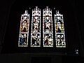 Stained glass window at St Cynhafal's Church - geograph.org.uk - 6054043.jpg 4,000 × 3,000; 2.24 MB
-
 Star, Llangynhafal - geograph.org.uk - 1042195.jpg 640 × 480; 49 KB
-
 Steep hill dropping towards Llangynhafal - geograph.org.uk - 6577714.jpg 4,000 × 3,000; 2.9 MB
-
 Stile besides Road. - geograph.org.uk - 760492.jpg 480 × 640; 122 KB
-
 Stone Circle near Llangynhafal - geograph.org.uk - 1042200.jpg 640 × 480; 166 KB
-
 Stryt Fawr Farm, Llanychan - geograph.org.uk - 2917575.jpg 640 × 480; 81 KB
-
-
 The Clwydian Hills - geograph.org.uk - 6577713.jpg 4,000 × 3,000; 2.44 MB
-
 The Golden Lion, Llangynhafal - geograph.org.uk - 4662274.jpg 3,264 × 2,448; 3.68 MB
-
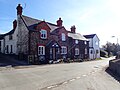 The Golden Lion, Llangynhafal - geograph.org.uk - 6070918.jpg 3,812 × 2,859; 1.81 MB
-
 The Jubilee Tower, Moel Famau - geograph.org.uk - 3253030.jpg 3,008 × 2,000; 427 KB
-
 The Old Rectory, Rhos - geograph.org.uk - 2917559.jpg 640 × 473; 63 KB
-
 The Parish Church of St Cynhafal at Llangynhafal - geograph.org.uk - 5986260.jpg 4,000 × 3,000; 2.13 MB
-
 The Path to Cilcain - geograph.org.uk - 4277632.jpg 1,600 × 1,200; 455 KB
-

-
 The village school, Gellifor - geograph.org.uk - 2917641.jpg 640 × 480; 61 KB
-
 The western side of the Clwydian Hills - geograph.org.uk - 1716298.jpg 2,272 × 1,712; 843 KB
-
 Track descending to Llangynhafal - geograph.org.uk - 6577697.jpg 4,000 × 3,000; 2.89 MB
-
 Track Junction below Pwll y Rhos - geograph.org.uk - 310801.jpg 640 × 480; 202 KB
-
 Trekkers on the Offa's Dyke Path - geograph.org.uk - 6577682.jpg 4,000 × 3,000; 2.41 MB
-
-
 Ty Coch Farmhouse - geograph.org.uk - 1042186.jpg 640 × 480; 67 KB
-
 Tyn y Celyn - geograph.org.uk - 218431.jpg 640 × 480; 127 KB
-
 Vale of Clwyd farm land - geograph.org.uk - 6507635.jpg 3,264 × 2,448; 3.13 MB
-
 View along the Clwydian Hills - geograph.org.uk - 2330478.jpg 480 × 640; 60 KB
-
 View From Moel Dywyll - geograph.org.uk - 4277658.jpg 1,600 × 1,200; 359 KB
-
 View from Moel Llys y Coed - geograph.org.uk - 6576069.jpg 4,000 × 3,000; 2.37 MB
-
 View from the Jubilee Tower, Moel Famau - geograph.org.uk - 3037923.jpg 5,184 × 3,456; 4.04 MB
-
 View from the Jubilee Tower, Moel Famau - geograph.org.uk - 3038437.jpg 5,184 × 3,456; 3.6 MB
-

-
 View into the Clwyd Valley - geograph.org.uk - 1171833.jpg 640 × 480; 102 KB
-
 View NE from Moel Famau - geograph.org.uk - 6460084.jpg 1,799 × 1,199; 343 KB
-
 View northwest from Moel Famau - geograph.org.uk - 6460076.jpg 1,800 × 1,200; 354 KB
-

-
 View to Moel Famau from Moel Llys y Coed - geograph.org.uk - 6576143.jpg 4,000 × 3,000; 2.92 MB
-
 View to the Vale of Clwyd from Moel Dywyll - geograph.org.uk - 6596764.jpg 3,829 × 2,871; 2.68 MB
-
 View to the Vale of Clwyd from Moel Llys y Coed - geograph.org.uk - 6577709.jpg 4,000 × 3,000; 3.04 MB
-
 View towards the Vale of Clwyd - geograph.org.uk - 5575803.jpg 4,973 × 3,315; 2.13 MB
-
 Village stocks at Plas Isaf - geograph.org.uk - 1921132.jpg 640 × 472; 186 KB
-
 Wales Denbighshire Community Llangynhafal map.svg 512 × 773; 560 KB
-
 War Memorial at Llangynhafal Church - geograph.org.uk - 135344.jpg 498 × 640; 125 KB
-
 Wenallt, on the Llangynhafal Community Miles Project - geograph.org.uk - 4662190.jpg 3,264 × 2,448; 5.05 MB
-
 Wenallt, on the Llangynhafal Community Miles Project - geograph.org.uk - 4662204.jpg 3,264 × 2,448; 6.06 MB
-
 Wenallt, on the Llangynhafal Community Miles Project - geograph.org.uk - 4662215.jpg 3,264 × 2,448; 4.38 MB
-
 Western flank of Moel Dywyll - geograph.org.uk - 6577703.jpg 4,000 × 3,000; 2.45 MB
-
 White Horse, Hendrerwydd - geograph.org.uk - 1042367.jpg 640 × 480; 73 KB
-
 White Horse, Hendrerwydd - geograph.org.uk - 2284597.jpg 640 × 480; 87 KB
-
 White Horse, Hendrerwydd - geograph.org.uk - 2917636.jpg 640 × 480; 90 KB
-
-

-
 A Tributary of the River Clwyd - geograph.org.uk - 760410.jpg 480 × 640; 124 KB
-

-
 Clwyd Tributary Stream. - geograph.org.uk - 760309.jpg 480 × 640; 121 KB
-
-
 Clwydian Hills near Moel Arthur - geograph.org.uk - 624466.jpg 640 × 480; 68 KB
-
 Enclosure on Moel Dywyll - geograph.org.uk - 615026.jpg 640 × 480; 61 KB
-
 Footpath Along Slopes of Moel Dywyll - geograph.org.uk - 760310.jpg 480 × 640; 122 KB
-
 Footpath and Stile near Plas Dolben - geograph.org.uk - 337746.jpg 480 × 640; 200 KB
-
 Footpath to Moel Arthur - geograph.org.uk - 760304.jpg 480 × 640; 108 KB
-
 Footpath to Moel Arthur. - geograph.org.uk - 760328.jpg 640 × 480; 82 KB
-
 Footpath to the Road to Llangynhafal - geograph.org.uk - 760498.jpg 480 × 640; 81 KB


_02.jpg)
_03.jpg)
_04.jpg)
_05.jpg)
_06.jpg)
_07.jpg)
_09.jpg)
_10.jpg)
_11.jpg)
_12.jpg)
_18.png)
_19.png)
_20.png)
_21.png)
_22.png)
_23.png)
_24.png)
_25.png)
_28.png)


