Category:Location maps of gminas in powiat płocki
Jump to navigation
Jump to search
Media in category "Location maps of gminas in powiat płocki"
The following 15 files are in this category, out of 15 total.
-
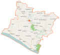
 Bielsk (gmina) location map.png 685 × 660; 99 KB
-
 Bodzanów (gmina) location map.png 850 × 633; 108 KB
-
 Brudzeń Duży (gmina) location map.png 752 × 692; 134 KB
-
 Bulkowo (gmina) location map.png 950 × 655; 121 KB
-
 Drobin (gmina) location map.png 970 × 818; 162 KB
-
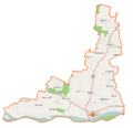
 Gąbin (gmina) location map.png 791 × 974; 179 KB
-
 Mała Wieś (gmina) location map.png 910 × 846; 129 KB
-
 Nowy Duninów (gmina) location map.png 1,321 × 765; 144 KB
-
 Radzanowo (gmina) location map.png 915 × 595; 110 KB
-
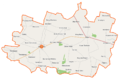
 Stara Biała (gmina) location map.png 838 × 817; 140 KB
-
 Staroźreby (gmina) location map.png 1,036 × 681; 146 KB
-
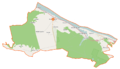
 Słubice (gmina w województwie mazowieckim) location map.png 689 × 892; 110 KB
-
 Słupno (gmina) location map.png 734 × 596; 110 KB
-
 Wyszogród (gmina) location map.png 922 × 888; 127 KB
-
 Łąck (gmina) location map.png 713 × 655; 129 KB
_location_map.png)
_location_map.png)
_location_map.png)
_location_map.png)
_location_map.png)
_location_map.png)
_location_map.png)
_location_map.png)
_location_map.png)
_location_map.png)
_location_map.png)
_location_map.png)
_location_map.png)
_location_map.png)
_location_map.png)