Category:Locator maps of former countries of North America (gray and green scheme)
Jump to navigation
Jump to search
Subcategories
This category has only the following subcategory.
Media in category "Locator maps of former countries of North America (gray and green scheme)"
The following 12 files are in this category, out of 12 total.
-
 5 nations attain independence in 1821 from Spain.png 250 × 115; 5 KB
-
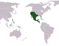
 First Mexican Empire Map.png 303 × 285; 38 KB
-
 La nueva españa 1.PNG 805 × 628; 25 KB
-
 Locatie Centraal Amerika.png 250 × 115; 5 KB
-
 Locatie Republica Mayor de Centro America.png 250 × 115; 4 KB
-
 LocationSt.Kitts Nevis Anguilla.PNG 250 × 115; 5 KB
-
 LokatieLosAltos.PNG 250 × 115; 5 KB
-
 Map of Los Altos.png 500 × 250; 29 KB
-
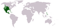
 Mexican Empire Map.png 267 × 257; 7 KB
-
 New Spain.png 1,357 × 628; 19 KB
-
 NuevaEspaña-Louisiana.jpg 852 × 433; 113 KB
-
 Ubicación Provincias Unidas del Centro de América.png 250 × 115; 5 KB


