Category:Locator maps of historic districts of England
Jump to navigation
Jump to search
Subcategories
This category has the following 4 subcategories, out of 4 total.
Media in category "Locator maps of historic districts of England"
The following 109 files are in this category, out of 109 total.
-
 Barnack RD 1933.png 777 × 455; 12 KB
-
 Blofield and East West Flegg RDs 1894.png 3,420 × 2,420; 180 KB
-
 Blofield and Flegg RD 1935.png 3,420 × 2,420; 152 KB
-
 Blyth RD 1934.png 1,825 × 2,300; 142 KB
-
 Blything RD 1894.png 1,825 × 2,300; 149 KB
-
 Bosmere and Claydon RD 1894.png 1,825 × 2,300; 149 KB
-
 Brandon RD 1894.png 1,470 × 1,740; 81 KB
-
 Caxton and Arrington RD 1894.png 1,665 × 1,422; 53 KB
-
 Chatteris UD 1935.png 1,470 × 1,468; 42 KB
-
 Chesterton RD 1894.png 1,665 × 1,422; 52 KB
-
 Chesterton RD 1934.png 1,665 × 1,422; 44 KB
-
 Clare RD 1894.png 1,470 × 1,740; 80 KB
-
 Clare RD 1935.png 1,470 × 1,740; 73 KB
-
 Cosford RD 1894.png 1,470 × 1,740; 82 KB
-
 Deben RD 1934.png 1,825 × 2,300; 142 KB
-
 Depwade RD 1894.png 3,420 × 2,420; 178 KB
-
 Docking RD 1935.png 3,420 × 2,420; 151 KB
-
 Downham RD 1894.png 3,420 × 2,420; 179 KB
-
 Downham RD 1935.png 3,420 × 2,420; 153 KB
-
 East Stow RD 1894.png 1,825 × 2,300; 149 KB
-
 Ely RD 1935.png 1,470 × 1,468; 42 KB
-
 Ely UD 1935.png 1,470 × 1,468; 42 KB
-
 Erpingham RD 1894.png 3,420 × 2,420; 177 KB
-
 Erpingham RD 1935.png 3,420 × 2,420; 151 KB
-
 Forehoe and Henstead RD 1935.png 3,420 × 2,420; 153 KB
-
 Forehoe and Henstead RDs 1894.png 3,420 × 2,420; 180 KB
-
 Freebridge Lynn RD 1935.png 3,420 × 2,420; 152 KB
-
 Gipping RD 1934.png 1,825 × 2,300; 142 KB
-
 Guiltcross RD 1894.png 3,420 × 2,420; 177 KB
-
 Hartismere RD 1894.png 1,825 × 2,300; 149 KB
-
 Hartismere RD 1934.png 1,825 × 2,300; 142 KB
-
 Hoxne RD 1894.png 1,825 × 2,300; 149 KB
-
 Huntingdon RD 1935.png 1,226 × 1,518; 45 KB
-
 Kings Lynn RD 1894.png 3,420 × 2,420; 177 KB
-
 Linton RD 1894.png 1,665 × 1,422; 52 KB
-
 Loddon RD 1935.png 3,420 × 2,420; 152 KB
-
 Lothingland RD 1934.png 1,825 × 2,300; 141 KB
-
 March UD 1935.png 1,470 × 1,468; 43 KB
-
 Marshland RD 1894.png 3,420 × 2,420; 179 KB
-
 Marshland RD 1935.png 3,420 × 2,420; 152 KB
-
 Melbourn RD 1894.png 1,665 × 1,422; 54 KB
-
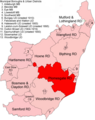
 Melford RD 1894.png 1,470 × 1,740; 82 KB
-
 Melford RD 1935.png 1,470 × 1,740; 73 KB
-
 Mildenhall RD 1894.png 1,470 × 1,740; 82 KB
-
 Mildenhall RD 1935.png 1,470 × 1,740; 73 KB
-
 Mitford and Launditch RD 1935.png 3,420 × 2,420; 153 KB
-
 Moulton RD 1894.png 1,470 × 1,740; 81 KB
-
 Mutford and Lothingland RD 1894.png 1,825 × 2,300; 148 KB
-
 Newmarket RD 1934.png 1,665 × 1,422; 43 KB
-
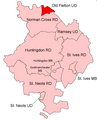
 Norman Cross RD 1935.png 1,226 × 1,518; 44 KB
-
 North Witchford RD 1935.png 1,470 × 1,468; 42 KB
-
 Northumberland AlnwickRD 1971.svg 1,052 × 744; 57 KB
-
 Northumberland AlnwickUD 1971.svg 1,052 × 744; 53 KB
-
 Northumberland AmbleUD 1971.svg 1,052 × 744; 55 KB
-
 Northumberland AshingtonUD 1971.svg 1,052 × 744; 54 KB
-
 Northumberland Bedlingtonshire 1971.svg 1,052 × 744; 56 KB
-
 Northumberland BelfordRD 1971.svg 1,052 × 744; 56 KB
-
 Northumberland BellinghamRD 1971.svg 1,052 × 744; 55 KB
-
 Northumberland BerwickMB 1971.svg 1,052 × 744; 55 KB
-
 Northumberland BlythMB 1971.svg 1,052 × 744; 54 KB
-
 Northumberland CastleWardRD1971.svg 1,052 × 744; 55 KB
-
 Northumberland GlendaleRD 1971.svg 1,052 × 744; 55 KB
-
 Northumberland GosforthUD 1971.svg 1,052 × 744; 55 KB
-
 Northumberland HaltwhistleRD 1971.svg 1,052 × 744; 54 KB
-
 Northumberland HexhamRD 1971.svg 1,052 × 744; 57 KB
-
 Northumberland HexhamUD 1971.svg 1,052 × 744; 54 KB
-
 Northumberland LongbentonUD 1971.svg 1,052 × 744; 56 KB
-
 Northumberland MorpethMB 1971.svg 1,052 × 744; 54 KB
-
 Northumberland MorpethRD 1971.svg 1,052 × 744; 56 KB
-
 Northumberland NewbigginUD 1971.svg 1,052 × 744; 55 KB
-
 Northumberland NewburnUD 1971.svg 1,052 × 744; 56 KB
-
 Northumberland NewcastleCB 1971.svg 1,052 × 744; 60 KB
-
 Northumberland NorhamIslandshiresRD 1971.svg 1,052 × 744; 125 KB
-
 Northumberland PrudhoeUD 1971.svg 1,052 × 744; 54 KB
-
 Northumberland RothburyRD 1971.svg 1,052 × 744; 55 KB
-
 Northumberland SeatonValleyUD 1971.svg 1,052 × 744; 55 KB
-
 Northumberland TynemouthCB 1971.svg 1,052 × 744; 56 KB
-
 Northumberland WallsendMB 1971.svg 1,052 × 744; 55 KB
-
 Northumberland WhitleyBayMB 1971.svg 1,052 × 744; 55 KB
-
 Old Fletton UD 1935.png 1,226 × 1,518; 44 KB
-
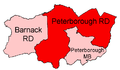 Peterborough RD 1933.png 777 × 455; 12 KB
-
 Plomesgate RD 1894.png 1,825 × 2,300; 149 KB
-
 Samford RD 1894.png 1,825 × 2,300; 149 KB
-
 Smallburgh RD 1894.png 3,420 × 2,420; 178 KB
-
 Smallburgh RD 1935.png 3,420 × 2,420; 152 KB
-
 South Cambridgeshire RD 1934.png 1,665 × 1,422; 43 KB
-
 St Faiths and Aylsham RD 1935.png 3,420 × 2,420; 152 KB
-
 St Faiths and Aylsham RDs 1894.png 3,420 × 2,420; 180 KB
-
 St Ives RD 1935.png 1,226 × 1,518; 45 KB
-
 St Neots RD 1935.png 1,226 × 1,518; 44 KB
-
 Swaffham RD 1894.png 3,420 × 2,420; 179 KB
-
 Swaffham RD 1935.png 3,420 × 2,420; 153 KB
-
 Swavesey RD 1894.png 1,665 × 1,422; 52 KB
-
 Thedwastre RD 1894.png 1,470 × 1,740; 81 KB
-
 Thetford RD 1894.png 3,420 × 2,420; 179 KB
-
 Thingoe RD 1894.png 1,470 × 1,740; 82 KB
-
 Thingoe RD 1935.png 1,470 × 1,740; 74 KB
-
 Thorney RD 1935.png 1,470 × 1,468; 42 KB
-
 Wainford RD 1934.png 1,825 × 2,300; 142 KB
-
 Walsingham RD 1935.png 3,420 × 2,420; 152 KB
-
 Wangford RD 1894.png 1,825 × 2,300; 149 KB
-
 Wayland RD 1894.png 3,420 × 2,420; 179 KB
-
 Wayland RD 1935.png 3,420 × 2,420; 152 KB
-
 Whittlesey RD 1894.png 1,470 × 1,468; 51 KB
-
 Whittlesey UD 1935.png 1,470 × 1,468; 43 KB
-
 Wisbech MB 1935.png 1,470 × 1,468; 42 KB
-
 Wisbech RD 1894.png 1,470 × 1,468; 51 KB
-
 Wisbech RD 1935.png 1,470 × 1,468; 43 KB
-
 Woodbridge RD 1894.png 1,825 × 2,300; 149 KB


