Category:Locator maps of legations in the Papal States (1850)
Jump to navigation
Jump to search
Italiano: Mappe di localizzazione delle legazioni dello Stato Pontificio secondo la riforma amministrativa del 1850.
Media in category "Locator maps of legations in the Papal States (1850)"
The following 6 files are in this category, out of 6 total.
-
 Stato Pontificio legazioni 1850.svg 960 × 1,080; 556 KB
-
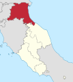
 Legation of the Marche Location.svg 960 × 1,080; 553 KB
-
 Legation of Marittima and Campagna Location.svg 960 × 1,080; 553 KB
-
 Circle of Rome location.svg 960 × 1,080; 554 KB
-
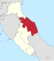
 Legation of the Romagne Location.svg 960 × 1,080; 553 KB
-
 Legation of Umbria Location.svg 960 × 1,080; 553 KB


