Category:Locator maps of parliamentary constituencies of Cleveland
Jump to navigation
Jump to search
Maps of Parliamentary constituencies in Cleveland.
Media in category "Locator maps of parliamentary constituencies of Cleveland"
The following 16 files are in this category, out of 16 total.
-
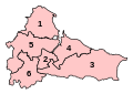 ClevelandParliamentaryConstituencies2007.svg 219 × 155; 57 KB
-
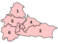 ClevelandParliamentaryConstituenciesNumbered.svg 200 × 150; 29 KB
-
 ClevelandParliamentaryConstituenciesNumbered2005.png 1,000 × 750; 78 KB
-
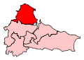 Hartlepool2007Constituency.svg 219 × 155; 89 KB
-
 HartlepoolConstituency.svg 200 × 150; 26 KB
-
 Langbaurgh1983Constituency.svg 43 × 30; 5 KB
-
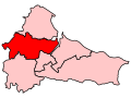
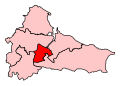 Middlesbrough2007Constituency.svg 219 × 155; 89 KB
-
 MiddlesbroughConstituency.svg 200 × 150; 26 KB
-
 MiddlesbroughSouthEastCleveland2007Constituency.svg 219 × 155; 89 KB
-
 MiddlesbroughSouthEastClevelandConstituency.svg 200 × 150; 26 KB
-
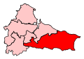
 Redcar2007Constituency.svg 219 × 155; 89 KB
-
 RedcarConstituency.svg 200 × 150; 26 KB
-
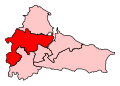 StocktonNorth2007Constituency.svg 219 × 155; 89 KB
-
 StocktonNorthConstituency.svg 200 × 150; 26 KB
-
 StocktonSouth2007Constituency.svg 219 × 155; 89 KB
-
 StocktonSouthConstituency.svg 200 × 150; 26 KB


