Category:Locator maps of preserved areas of Svalbard
Jump to navigation
Jump to search
Media in category "Locator maps of preserved areas of Svalbard"
The following 17 files are in this category, out of 17 total.
-
 Bjørnøya Nature Reserve locator map.svg 2,208 × 2,821; 971 KB
-
 Festningen Geotope Preservation Area locator map.svg 2,208 × 2,821; 971 KB
-
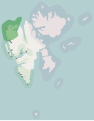
 Forlandet National Park locator map.svg 2,208 × 2,821; 971 KB
-
 Hopen Nature Reserve locator map.svg 2,208 × 2,821; 971 KB
-
 Indre Wijdefjorden National Park locator map.svg 2,208 × 2,821; 971 KB
-
 Moffen Nature Reserve locator map.svg 2,208 × 2,821; 971 KB
-
 Nordaust-Svalbard Nature Reserve locator map.svg 2,208 × 2,821; 971 KB
-
 Nordenskiöld Land National Park locator map.svg 2,208 × 2,821; 971 KB
-
 Nordre Isfjorden National Park locator map.svg 2,208 × 2,821; 971 KB
-
 Nordvest-Spitsbergen National Park locator map.svg 2,208 × 2,821; 971 KB
-
 Ossian Sars Nature Reserve locator map.svg 2,208 × 2,821; 971 KB
-
 Sassen-Bünsow Land National Park locator map.svg 2,208 × 2,821; 971 KB
-
 Svalbard protected areas map 1973.svg 2,208 × 2,821; 943 KB
-
 Svalbard protected areas map with names.svg 2,208 × 2,821; 1.01 MB
-
 Svalbard protected areas map.svg 2,208 × 2,821; 971 KB
-
 Sør-Spitsbergen National Park locator map.svg 2,208 × 2,821; 971 KB
-
 Søraust-Svalbard Nature Reserve locator map.svg 2,208 × 2,821; 971 KB


