Category:Locator maps of territories of the United States of Venezuela
Jump to navigation
Jump to search
Subcategories
This category has only the following subcategory.
Media in category "Locator maps of territories of the United States of Venezuela"
The following 7 files are in this category, out of 7 total.
-
 Territorio Armisticio.PNG 1,800 × 1,583; 39 KB
-
 Territorio Federal Amazonas (1856 - 1881).PNG 1,800 × 1,800; 42 KB
-
 Territorio Federal Amazonas (1881 - 1893).PNG 1,800 × 1,800; 43 KB
-
 Territorio Federal Amazonas 1893 - 1992.PNG 1,800 × 1,583; 38 KB
-
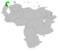
 Territorio Federal Delta Amacuro (1884 - 1893).PNG 2,000 × 1,583; 40 KB
-
 Territorio Federal Delta Amacuro (1901 - 1991).PNG 1,772 × 1,583; 38 KB
-
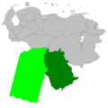
 Territorio Federal Guajira.PNG 1,800 × 1,583; 38 KB

.PNG)
.PNG)

.PNG)
.PNG)
