Category:Lot River
Jump to navigation
Jump to search
river in France  most Pont Valentré přes řeku v Cahors .png) | |||||
| Upload media | |||||
| Instance of | |||||
|---|---|---|---|---|---|
| Location |
| ||||
| Length |
| ||||
| Origin of the watercourse | |||||
| Mouth of the watercourse | |||||
| Drainage basin |
| ||||
| Tributary |
| ||||
| Dam | |||||
| Different from | |||||
 | |||||
Subcategories
This category has the following 8 subcategories, out of 8 total.
Media in category "Lot River"
The following 40 files are in this category, out of 40 total.
-

-
 Boucle du lot.jpg 4,032 × 3,024; 4.23 MB
-
 Bouziès pont.jpg 3,872 × 1,872; 3.1 MB
-
 Chipole-vallée-du-Lot.JPEG 1,920 × 1,080; 898 KB
-
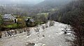 Inondations 2.jpg 3,264 × 1,836; 1.47 MB
-
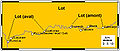 Lot drawing final.jpg 449 × 190; 21 KB
-
 Lot ibaia Sainte Eulalie d'Olt parean.jpg 4,608 × 3,456; 3.15 MB
-
 Lot River in Montarnal 01.jpg 2,000 × 3,000; 6.65 MB
-
 Lot River in Montarnal 02.jpg 3,000 × 2,000; 7.25 MB
-
 Lot River in Montarnal 03.jpg 3,000 × 2,000; 6.8 MB
-
 Lot whole original out.jpg 800 × 302; 49 KB
-
 Lot-02-Roque Bouillac-2001-gje.jpg 3,208 × 2,152; 1.21 MB
-
 Lot-04-Landschaft am Lot-2001-gje.jpg 3,328 × 2,200; 1.24 MB
-
 Lot-06-Landschaft am Lot-2001-gje.jpg 3,040 × 2,080; 1.04 MB
-
 Lot-08-Landschaft am Lot-2001-gje.jpg 3,288 × 2,184; 1.11 MB
-
 Lot-10-Port d'arges-Villa-2001-gje.jpg 2,989 × 1,445; 760 KB
-
 Lot-12-Saint-Parthen-Strasse-2001-gje.jpg 2,536 × 2,080; 909 KB
-
 Lot-14-Landschaft am Lot-2001-gje.jpg 2,912 × 2,192; 1,013 KB
-
 Lot-16-Landschaft am Lot-2001-gje.jpg 3,280 × 2,152; 1.27 MB
-
 Lot-18-Landschaft am Lot-2001-gje.jpg 3,216 × 2,080; 1.26 MB
-
 Lot-20-Viellevie-Burg-2001-gje.jpg 2,192 × 2,520; 790 KB
-
 Panoramic of Capdenac-Gare.jpg 5,138 × 1,719; 5.36 MB
-
 Rives du Lot, à Cahors (46) - panoramio.jpg 2,919 × 1,687; 794 KB
-
 RivierLot.png 1,731 × 1,128; 3.07 MB
-
 St. Cirq Lapopie River Lot.jpg 3,000 × 4,000; 6.88 MB
-
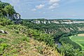
 Valley of the Lot River 01.jpg 3,053 × 1,963; 5.84 MB
-
 Valley of the Lot River 02.jpg 3,477 × 2,154; 5.65 MB
-
 Valley of the Lot River 03.jpg 3,223 × 2,175; 5.24 MB
-
 Valley of the Lot River 04.jpg 1,897 × 2,881; 3.77 MB
-
 Valley of the Lot River 05.jpg 2,841 × 2,239; 4.98 MB
-
 Valley of the Lot River 06.jpg 2,884 × 1,923; 5.79 MB
-
 Valley of the Lot River 07.jpg 3,000 × 1,915; 5.82 MB
-
 Vallée du Lot, vers Vers (46) - panoramio.jpg 2,173 × 1,251; 528 KB
-
 View of Lot River from Saut de la Mounine 01.jpg 3,727 × 2,167; 7.5 MB
-
 View of Lot River from Saut de la Mounine 02.jpg 3,700 × 2,467; 9.23 MB
-
 View of Lot River from Saut de la Mounine 03.jpg 2,561 × 4,227; 11.25 MB
-
 View of Lot River from Saut de la Mounine 04.jpg 3,651 × 2,434; 8.93 MB
-
 View of Lot River from Saut de la Mounine 05.jpg 3,646 × 2,431; 7.87 MB
-
 View of Lot River from Saut de la Mounine 06.jpg 1,769 × 3,200; 5.03 MB
-
 View of Lot River from Saut de la Mounine 07.jpg 3,431 × 2,535; 8.39 MB


_-_panoramio.jpg)


_-_panoramio.jpg)


