Category:Low Isles Light
Jump to navigation
Jump to search
| Object location | | View all coordinates using: OpenStreetMap |
|---|
English: Low Isles Light
lighthouse in Queensland, Australia | |||||
| Upload media | |||||
| Instance of |
| ||||
|---|---|---|---|---|---|
| Location | Port Douglas, Shire of Douglas, Queensland, AUS | ||||
| Heritage designation |
| ||||
| Service entry |
| ||||
| Inception |
| ||||
| Source of energy | |||||
| Area |
| ||||
 | |||||
Media in category "Low Isles Light"
The following 8 files are in this category, out of 8 total.
-
Coral Sea, Queensland (483711) (9443454862).jpg 3,776 × 2,122; 1.54 MB
-
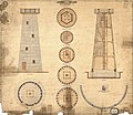
Low Island Lighthouse, 1874.jpg 2,953 × 2,551; 916 KB
-
Low Isle viewed from the south west ,1928.jpg 600 × 428; 58 KB
-
Low Isles Lighthouse, Coral Sea, Queensland (483836) (9440792849).jpg 3,936 × 2,210; 1.92 MB
-
Low Isles Lighthouse, Coral Sea, Queensland - panoramio.jpg 2,048 × 1,150; 529 KB
-
Low Isles Lighthouse.jpg 1,486 × 2,003; 1.8 MB
-
Low Isles panorama.jpg 3,366 × 471; 813 KB
-
Low Isles unknown date.jpg 524 × 591; 64 KB


