Category:Lower Sydenham (Winsford Road) Gauging Station
Jump to navigation
Jump to search
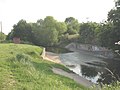
English: Described as a trapezoidal, critical depth flume constructed in 1974.
Media in category "Lower Sydenham (Winsford Road) Gauging Station"
The following 6 files are in this category, out of 6 total.
-
-
 Gauging Station, Pool River near Catford - geograph.org.uk - 2315177.jpg 640 × 480; 124 KB
-

-

-

-


_Gauging_Station_on_the_Pool_River_(2)_-_geograph.org.uk_-_2272027.jpg)
_Gauging_Station_on_the_Pool_River_(3)_-_geograph.org.uk_-_2272034.jpg)
_Gauging_Station_on_the_Pool_River_-_geograph.org.uk_-_2272023.jpg)
_Gauging_Station_on_the_Pool_River_-_geograph.org.uk_-_2272043.jpg)