Category:Lusatia
Pereiti į navigaciją
Jump to search

historical region in Central Europe   posizion zeografega de la Lusazia | |||||
| Įkelti mediją | |||||
| Tai yra | |||||
|---|---|---|---|---|---|
| Pavadintas pagal | |||||
| Vieta | |||||
| Susideda iš | |||||
| Plotas |
| ||||
| Skiriasi nuo | |||||
 | |||||
Deutsch: Die Lausitz ist eine Landschaft in Mitteleuropa, die in Ostdeutschland (Brandenburg und Sachsen) und Westpolen (Niederschlesien, Lebus) liegt.
English: Lusatia is a landscape in Middle Europe. It lies in Germany (states of Brandenburg and Saxony) and Poland (Lower Silesian and Lubusz Voivodeships).
Hornjoserbsce: Łužica je srjedźnoeuropska krajina, kotraž słuša k němskimaj krajomaj Sakskej a Braniborskej a zdźěla k Pólskej.
Polski: Łużyce jest to kraina geograficzno-historyczna w Niemczech (i częściowo w Polsce).
Subkategorijos
Šioje kategorijoje yra viena subkategorija.
Puslapiai kategorijoje „Lusatia“
Šioje kategorijoje yra vienas puslapis.
Daugialypės terpės rinkmenos kategorijoje „Lusatia“
Rodomi 37 šios kategorijos rinkmenos (iš viso kategorijoje yra 37 rinkmenos).
-
 Acrocephalus arundinaceus nest (cropped).jpg 961 × 1 159; 523 KiB
-
 Aussichtsturm gosda Weißag Calauer Schweiz1.jpg 620 × 875; 127 KiB
-
 Brakteat02.jpg 500 × 480; 163 KiB
-
 Bueschings Erdbeschreibung Teil 05 7A.pdf 1 275 × 1 650, 1 078 puslapiai; 58,15 MiB
-
De-Lausitz.ogg 2,0 s; 21 KiB
-
 Die Lausitz war hier - panoramio.jpg 1 181 × 886; 479 KiB
-
 Feldbahnlokomotive der Lausitzer Werkbahn.jpg 1 298 × 880; 312 KiB
-
 Findling für den Ort Gosda (2017).jpg 3 024 × 4 032; 5,58 MiB
-
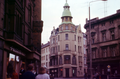
 Fotothek df ps 0000352 001.jpg 800 × 548; 260 KiB
-
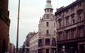
 Fotothek df ps 0000352 002.jpg 800 × 548; 261 KiB
-
 Gedenk- und Informationsstätte Klein Görigk im Jahr 2017.jpg 4 032 × 3 024; 4,69 MiB
-
 Gedenkstein Klein Buckow.jpg 3 024 × 4 032; 5,76 MiB
-
 Gedenkstätte für den Ort Tranitz, Findling und Informationstafel (2017).jpg 4 032 × 3 024; 5,89 MiB
-
 Gedenkstätte mit Informationstafel, Bank und Findling für Gosda (2017).jpg 4 032 × 3 024; 4,18 MiB
-
 Grenze zwischen Ober- und Niederlausitz bei Köbeln.jpg 2 560 × 1 920; 1,32 MiB
-
 Hornolužické Šesťmestie.svg 512 × 395; 177 KiB
-
 Hussites.gif 922 × 692; 621 KiB
-
 Jurij Chěžka.jpg 256 × 328; 59 KiB
-
 Karte Hohwald.png 736 × 560; 29 KiB
-
 Kd3 krauschwitz drachenberg doppelgieser noerdliche senke.jpg 4 592 × 3 056; 7,22 MiB
-
 Lausitz0001.png 2 877 × 1 890; 5,86 MiB
-
 Lausitz0003.png 2 877 × 1 804; 5,56 MiB
-
 Lausitzer-Granodiorit.jpg 1 696 × 2 544; 1,12 MiB
-
 Lausitzer-Radfahrer-Bund (Logo).png 295 × 295; 65 KiB
-
-
 Logo Geopark Muskauer Faltenbogen.jpg 314 × 223; 40 KiB
-
 Lutki auf Posten.JPG 3 648 × 2 736; 3,47 MiB
-
 Malxe bei Forst Lausitz.jpg 4 032 × 3 024; 5,33 MiB
-

-
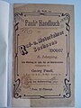
 Paulis Handbuch der Rad- und Motorradfahrer Sachsens 1906, 1. Teil.jpg 2 448 × 3 264; 1,27 MiB
-
 Paulis Handbuch der Rad- und Motorradfahrer Sachsens 1906, II. Teil.jpg 2 448 × 3 264; 1 006 KiB
-
Pl-Łużyce.ogg 1,2 s; 15 KiB
-
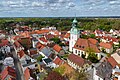 Ruhland 2024 Luftbild Toni Klemm 2500px.jpg 2 500 × 1 667; 1,72 MiB
-
 UnterrichtungstafelNaturpark nl landruecken.JPG 959 × 680; 117 KiB
-
 Wegweiser Knotenpunkt B112-B157 in Forst(Lausitz) .png 458 × 640; 20 KiB
-
 Wegweiser-Kathlow.png 719 × 635; 16 KiB
-
 Wendische Fastnacht im Spreewald.jpg 7 636 × 5 091; 20,54 MiB
.jpg)


.jpg)


.jpg)
.jpg)


.png)
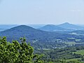
_im_Lausitzer_Gebirge,_dahinter_mittig_der_T%C3%B6lzberg_(Tlustec)_und_rechts_im_Hintergrund_der_Roll_(Ralsko).jpg)


.jpg)


_.png)

