Category:Lutheran church in Zemianske Podhradie
Jump to navigation
Jump to search
| Object location | | View all coordinates using: OpenStreetMap |
|---|
| This category shows the protected monument with the number 304-1394/0 (other) in the Slovak Republic. |
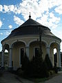
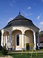
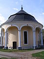
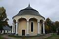
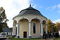
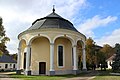
Slovenčina: Klasicistický evanjelický kostol v obci Zemianske Podhradie, okres Nové Mesto nad Váhom. Stavba na kruhovom pôdoryse z rokov 1784-1801.
Subcategories
This category has only the following subcategory.
Media in category "Lutheran church in Zemianske Podhradie"
The following 15 files are in this category, out of 15 total.
-
 Zemianske Podhradie, kostel (1).jpg 2,304 × 3,072; 1,024 KB
-
 Zemianske Podhradie, kostel (2).jpg 3,072 × 2,304; 1.09 MB
-
 Zemianske Podhradie, kostel (3).jpg 2,304 × 3,072; 1.13 MB
-
 Zemianske Podhradie, kostel (4).jpg 3,072 × 2,304; 1.11 MB
-
 Zemianske Podhradie, kostel (5).jpg 2,304 × 3,072; 1.11 MB
-
 Zemianske Podhradie, kostel (6).jpg 3,173 × 4,142; 4.99 MB
-
 Zemianske Podhradie, kostel, nivelační značka.jpg 2,304 × 3,072; 1.04 MB
-
 Zemianske Podhradie, kostel, vstup.jpg 2,304 × 3,072; 1.08 MB
-
 Zemianske Podhradie, kulatý kostel (1).jpg 5,184 × 3,456; 5.63 MB
-
 Zemianske Podhradie, kulatý kostel (2).jpg 5,184 × 3,456; 5.63 MB
-
 Zemianske Podhradie, kulatý kostel (3).jpg 5,184 × 3,456; 5.74 MB
-
 Zemianske Podhradie, kulatý kostel (4).jpg 5,184 × 3,456; 6.13 MB
-
 Zemianske Podhradie, kulatý kostel (5).jpg 5,184 × 3,456; 6 MB
-
 Zemianske Podhradie, kulatý kostel (6).jpg 5,184 × 3,456; 5.93 MB
-
 Zemianske Podhradie, vstup do kostela.jpg 3,456 × 5,184; 5.14 MB
.jpg)
.jpg)
.jpg)
.jpg)
.jpg)
.jpg)


.jpg)
.jpg)
.jpg)
.jpg)
.jpg)
.jpg)
