Category:Mühlenplatzbrunnen (Mattebrunnen)
Jump to navigation
Jump to search
| Object location | | View all coordinates using: OpenStreetMap |
|---|
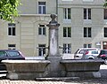
Deutsch: Der Mühlenplatzbrunnen ist ein Brunnen mit Stock und zwei Becken am Mühlenplatz neben dem Mattebach im Mattequartier in der Stadt Bern in der Schweiz.
 | |||||
| Upload media | |||||
| Instance of |
| ||||
|---|---|---|---|---|---|
| Part of | |||||
| Made from material | |||||
| Genre | |||||
| Location | |||||
| Street address |
| ||||
| Owned by | |||||
| Operator | |||||
| Inception |
| ||||
| Elevation above sea level |
| ||||
 | |||||
Media in category "Mühlenplatzbrunnen (Mattebrunnen)"
The following 3 files are in this category, out of 3 total.
-
 Bern - Mühleplatz.jpg 2,048 × 1,536; 682 KB
-
 Bern - Mühleplatzbrunnen.jpg 1,528 × 1,212; 310 KB
-
 BernMatteMuehlenplatz.JPG 2,048 × 1,536; 1.77 MB

