Category:Ma'ale Hever
Jump to navigation
Jump to search
Israeli settlement in the West Bank  | |||||
| Upload media | |||||
| Instance of | |||||
|---|---|---|---|---|---|
| Location | Har Hevron Regional Council, Judea and Samaria Area | ||||
| Inception |
| ||||
| Population |
| ||||
| Elevation above sea level |
| ||||
| official website | |||||
 | |||||
Media in category "Ma'ale Hever"
The following 8 files are in this category, out of 8 total.
-
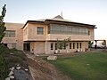 Yeshiva ma'ale hever.jpg 3,648 × 2,736; 4.25 MB
-
 בית במעלה חבר.jpg 3,888 × 2,592; 4.41 MB
-
 בתים בישוב.jpg 3,888 × 2,592; 1.99 MB
-
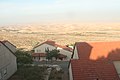
 בתים ונוף בישוב.jpg 3,888 × 2,592; 1.99 MB
-
 מעלה חבר.jpg 3,888 × 2,592; 3.93 MB
-
 רחוב נחל ערוגות במעלה חבר.jpg 3,888 × 2,592; 2.03 MB
-
 רחוב נחל ערוגות.jpg 3,888 × 2,592; 4 MB
-
 תצלום אווירי של מעלה חבר.jpg 4,000 × 3,000; 4.66 MB


