Category:Maasstraat 6, Grave
Jump to navigation
Jump to search
| Object location | | View all coordinates using: OpenStreetMap |
|---|
house in Grave, Netherlands  | |||||
| Upload media | |||||
| Instance of | |||||
|---|---|---|---|---|---|
| Location | Grave, Land van Cuijk, North Brabant, Netherlands | ||||
| Street address |
| ||||
| Located on street | |||||
| Heritage designation |
| ||||
 | |||||
|
This is a category about rijksmonument number 17275
|
| Address |
|
Media in category "Maasstraat 6, Grave"
The following 6 files are in this category, out of 6 total.
-
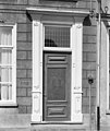 Deuromlijsting - Grave - 20084123 - RCE.jpg 1,012 × 1,200; 237 KB
-
 Gootlijst - Grave - 20084122 - RCE.jpg 1,200 × 1,010; 215 KB
-
 Grave - Maasstraat 6.jpg 1,944 × 2,592; 1.28 MB
-
 Overzicht - Grave - 20084124 - RCE.jpg 968 × 1,200; 259 KB
-
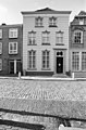
 Voorgevel - Grave - 20084121 - RCE.jpg 954 × 1,200; 236 KB
-
 Voorgevel - Grave - 20084125 - RCE.jpg 788 × 1,200; 232 KB


