Category:Madingley
Jump to navigation
Jump to search
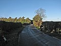
English: Madingley is a village near Coton and Dry Drayton on the western outskirts of Cambridge in the United Kingdom. The village's former public house, The Three Horseshoes, is now a good-quality restaurant though it still has a bar that serves beer. The village has an independent pre-preparatory school which caters for reception to year-two students. The village's community spirit is exemplified by the yearly quiz. There is also a village church, which still takes services weekly.There is a B&B at Beck Brook Farm.
village in South Cambridgeshire, England  | |||||
| Upload media | |||||
| Instance of | |||||
|---|---|---|---|---|---|
| Location | South Cambridgeshire, Cambridgeshire, East of England, England | ||||
| Population |
| ||||
 | |||||
Subcategories
This category has the following 7 subcategories, out of 7 total.
Media in category "Madingley"
The following 200 files are in this category, out of 363 total.
(previous page) (next page)-
 'Reflective View' - geograph.org.uk - 6180717.jpg 852 × 1,024; 206 KB
-
 Neale(1824) p1.017 - Madingley Bridge and Church.jpg 1,198 × 705; 227 KB
-
 800 Wood - geograph.org.uk - 4951222.jpg 3,264 × 1,840; 2.58 MB
-
 800 Wood near Madingley - geograph.org.uk - 4440513.jpg 1,600 × 1,200; 613 KB
-
 800 Wood, Madingley - geograph.org.uk - 6226074.jpg 1,600 × 1,067; 506 KB
-
 A1303 - geograph.org.uk - 5352975.jpg 640 × 426; 66 KB
-
 A1303 - geograph.org.uk - 5352978.jpg 640 × 426; 77 KB
-
 A1303 St.Neots Road - geograph.org.uk - 4765939.jpg 3,072 × 2,304; 2.17 MB
-
 A1303 St.Neots Road, Coton - geograph.org.uk - 4765949.jpg 640 × 480; 96 KB
-
 A1303 St.Neots Road, Coton - geograph.org.uk - 4766443.jpg 3,072 × 2,304; 1.95 MB
-
 A1303 St.Neots Road, Madingley - geograph.org.uk - 4767340.jpg 3,072 × 2,304; 1.76 MB
-
 A14 at Girton Interchange - geograph.org.uk - 3874886.jpg 640 × 427; 237 KB
-
 A14 south Cambridgeshire - geograph.org.uk - 90043.jpg 640 × 480; 212 KB
-
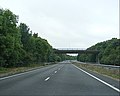
 A428 - geograph.org.uk - 3664465.jpg 2,293 × 2,138; 549 KB
-
 A428 and road-building works - geograph.org.uk - 5343230.jpg 3,872 × 2,592; 2.86 MB
-
 A428 approaching Cambridge - geograph.org.uk - 4440443.jpg 1,600 × 1,200; 421 KB
-
 A428 approaching the Church Lane Bridge - geograph.org.uk - 3664505.jpg 2,914 × 2,189; 947 KB
-
 A428 approaching to Cambridge Road Bridge - geograph.org.uk - 3664488.jpg 2,564 × 2,046; 873 KB
-

-
 A428 junction - geograph.org.uk - 4285877.jpg 3,072 × 2,304; 1.82 MB
-
 A428 near Park Farm - geograph.org.uk - 5085329.jpg 640 × 480; 33 KB
-
 A428 roadworks - geograph.org.uk - 6226072.jpg 1,600 × 1,067; 278 KB
-
 A428 through Madingley, looking northeast - geograph.org.uk - 16723.jpg 640 × 480; 128 KB
-
 A428 to Bedford - geograph.org.uk - 4285907.jpg 3,072 × 2,304; 1.47 MB
-
 A428 to Cambridge - geograph.org.uk - 4285905.jpg 3,072 × 2,304; 1.74 MB
-
 A428 under Church Lane Bridge - geograph.org.uk - 3664511.jpg 2,683 × 2,305; 984 KB
-
 A428, eastbound - geograph.org.uk - 5005322.jpg 640 × 426; 51 KB
-
 Accommodation bridge over A428 - geograph.org.uk - 5343300.jpg 3,872 × 2,592; 3.29 MB
-
 Across the A428 - geograph.org.uk - 4593924.jpg 1,024 × 732; 1,023 KB
-
 Along Whitwell Way - geograph.org.uk - 4745220.jpg 1,024 × 732; 1.03 MB
-
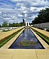
 American Cemetery and Memorial - geograph.org.uk - 5463408.jpg 3,264 × 2,448; 3.9 MB
-
 Autumn at the roundabout - geograph.org.uk - 1043630.jpg 640 × 480; 61 KB
-
 Autumnal scene - geograph.org.uk - 1043187.jpg 640 × 480; 128 KB
-
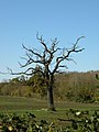 Bare tree near New Farm - geograph.org.uk - 1043104.jpg 480 × 640; 79 KB
-
 Barley and barns - geograph.org.uk - 4593962.jpg 1,024 × 731; 1.04 MB
-
 Barley by Whitwell Way - geograph.org.uk - 4526238.jpg 1,600 × 1,200; 724 KB
-
 Barley by Whitwell Way - geograph.org.uk - 4526245.jpg 1,600 × 1,200; 534 KB
-
 Barley field and corrugated barns - geograph.org.uk - 4594024.jpg 1,024 × 731; 1.09 MB
-
 Barley field and distant cranes - geograph.org.uk - 4593954.jpg 1,024 × 768; 1.12 MB
-
 Blocked track - geograph.org.uk - 612779.jpg 640 × 480; 139 KB
-
 Boundary Plantation left of fields - geograph.org.uk - 4952580.jpg 3,264 × 1,840; 2.77 MB
-
 Bridle path from Girton to Madingley - geograph.org.uk - 4593861.jpg 1,024 × 732; 1,015 KB
-
 Bridle path from Girton to Madingley - geograph.org.uk - 4593950.jpg 1,024 × 731; 1,018 KB
-
 Bridle path from Madingley to Girton - geograph.org.uk - 4593945.jpg 1,024 × 732; 1.1 MB
-
 Bridleway from Cambridge Road - geograph.org.uk - 6226061.jpg 1,600 × 1,067; 522 KB
-
 Bridleway from Madingley - geograph.org.uk - 2720272.jpg 2,592 × 1,944; 1.78 MB
-
 Bridleway near the A428 - geograph.org.uk - 4951266.jpg 3,264 × 1,840; 2.52 MB
-
 Bridleway past barn - geograph.org.uk - 4437195.jpg 1,600 × 1,200; 778 KB
-
 Bridleway past Little Shrubs - geograph.org.uk - 1043130.jpg 640 × 480; 168 KB
-
 Bridleway to A14 - geograph.org.uk - 1043114.jpg 640 × 515; 140 KB
-
 Bridleway to A14 - geograph.org.uk - 4440457.jpg 1,600 × 1,200; 957 KB
-
 Bridleway to A14 junction - geograph.org.uk - 4440477.jpg 1,600 × 1,200; 616 KB
-
 Bridleway to Huntingdon Road - geograph.org.uk - 3754520.jpg 1,024 × 765; 1.16 MB
-
 Bridleway to Huntingdon Road - geograph.org.uk - 4951261.jpg 3,264 × 1,840; 2.68 MB
-
 Bridleway to the Huntingdon Road - geograph.org.uk - 1043097.jpg 640 × 480; 77 KB
-
 Bridleway towards A14 Underpass - geograph.org.uk - 4951276.jpg 3,264 × 1,840; 2.52 MB
-
 Brook Cottage, Cambridge Road - geograph.org.uk - 1042724.jpg 640 × 480; 124 KB
-
 Cambridge American Cemetery - geograph.org.uk - 5352967.jpg 640 × 426; 77 KB
-
 Cambridge American Cemetery - geograph.org.uk - 5689951.jpg 6,800 × 4,480; 2.6 MB
-
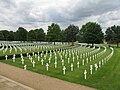 Cambridge American Cemetery and Memorial - geograph.org.uk - 5463395.jpg 3,264 × 2,448; 3.86 MB
-

-
 Cambridge American Military Cemetery, Madingley - geograph.org.uk - 5910821.jpg 4,000 × 3,000; 4.72 MB
-
 Cambridge American Military Cemetery, Madingley - geograph.org.uk - 5910828.jpg 4,000 × 3,000; 4.66 MB
-
 Cambridge American Military Cemetery, Madingley - geograph.org.uk - 5910853.jpg 4,000 × 3,000; 4.86 MB
-
 Cambridge American Military Cemetery, Madingley - geograph.org.uk - 5910862.jpg 3,792 × 2,843; 1.72 MB
-
 Cambridge Crematorium - geograph.org.uk - 90044.jpg 640 × 480; 403 KB
-
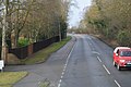
 Cambridge Road - geograph.org.uk - 1564056.jpg 640 × 480; 61 KB
-
 Cambridge Road - geograph.org.uk - 1564069.jpg 480 × 640; 50 KB
-
 Cambridge Road - geograph.org.uk - 2851717.jpg 4,000 × 3,000; 4.09 MB
-
 Cambridge Road - Madingley - geograph.org.uk - 1564066.jpg 480 × 640; 60 KB
-
 Cambridge Road near Madingley - geograph.org.uk - 2848662.jpg 4,000 × 3,000; 4.46 MB
-
 Cambridge Road near the American Cemetery - geograph.org.uk - 3278447.jpg 1,024 × 724; 289 KB
-
 Cambridge Road sign - geograph.org.uk - 4286086.jpg 3,072 × 2,304; 1.91 MB
-
 Cambridge Road, Madingley - geograph.org.uk - 4286075.jpg 3,072 × 2,304; 1.65 MB
-
 Cambridge Road, Madingley - geograph.org.uk - 6476419.jpg 1,920 × 1,280; 1.43 MB
-
 Cambridge Road, Madingley - geograph.org.uk - 6476833.jpg 1,888 × 1,230; 2.25 MB
-
 Cambridge University 800th Anniversary Woodland 2007-8 - geograph.org.uk - 4951249.jpg 2,048 × 1,111; 1.35 MB
-

-
 Catch Hall - geograph.org.uk - 685613.jpg 640 × 480; 58 KB
-
 Chapel at Madingley - geograph.org.uk - 5463405.jpg 3,264 × 2,448; 3.37 MB
-
 Chapel Interior - geograph.org.uk - 6630465.jpg 3,072 × 2,048; 2.62 MB
-
 Church Lane bridges the A428 - geograph.org.uk - 6064070.jpg 1,024 × 684; 226 KB
-
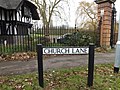 Church Lane sign - geograph.org.uk - 4285942.jpg 3,072 × 2,304; 1.82 MB
-
 Church Lane ^ bridge over the A428 - geograph.org.uk - 4285882.jpg 3,072 × 2,304; 1.83 MB
-
 Church Lane, Madingley - geograph.org.uk - 4285885.jpg 3,072 × 2,304; 1.54 MB
-
 Church Lane, Madingley - geograph.org.uk - 4285910.jpg 3,072 × 2,304; 1.76 MB
-
 Church Lane, Madingley - geograph.org.uk - 4285921.jpg 3,072 × 2,304; 1.8 MB
-
 Church Lane, Madingley - geograph.org.uk - 4285930.jpg 3,072 × 2,304; 1.88 MB
-
 Church Lane, Madingley - geograph.org.uk - 4285941.jpg 3,072 × 2,162; 2.01 MB
-
 Church of St Mary Magdalene, Madingley - geograph.org.uk - 6689139.jpg 716 × 1,024; 203 KB
-
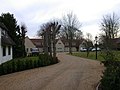
 Cmglee Madingley high street.jpg 2,048 × 1,024; 256 KB
-
 Coton to Girton - geograph.org.uk - 3024860.jpg 1,024 × 768; 1.06 MB
-
 Coton, on Whitwell Way - geograph.org.uk - 6451562.jpg 1,024 × 683; 782 KB
-
 Coton, tree, gate and sheds - geograph.org.uk - 4745009.jpg 819 × 1,024; 1.22 MB
-
 Crome Lea Business Park sign - geograph.org.uk - 4767331.jpg 3,072 × 2,304; 1.75 MB
-
 Cycling to Madingley - geograph.org.uk - 3754505.jpg 1,024 × 771; 186 KB
-
 Ditch between fields - geograph.org.uk - 1070020.jpg 640 × 480; 151 KB
-
 Ditch but no hedge - geograph.org.uk - 1564142.jpg 480 × 640; 81 KB
-
 Down the hill to Madingley - geograph.org.uk - 3754539.jpg 1,024 × 1,024; 1,011 KB
-
 Drainage ditch and misty fields - geograph.org.uk - 2829504.jpg 1,024 × 768; 1.09 MB
-
 Dry Drayton Road - geograph.org.uk - 5584501.jpg 640 × 422; 71 KB
-
 Dry Drayton Road - geograph.org.uk - 6064084.jpg 1,024 × 684; 280 KB
-
 Dry Drayton Road, Madingley - geograph.org.uk - 4771561.jpg 1,280 × 851; 300 KB
-
 Dry Drayton Road, Madingley - geograph.org.uk - 5555061.jpg 3,872 × 2,592; 3.1 MB
-
 Dry Drayton Road, Madingley - geograph.org.uk - 6476958.jpg 1,878 × 1,214; 1.6 MB
-
 Edge of Field near the A428 - geograph.org.uk - 4951154.jpg 3,264 × 1,840; 2.72 MB
-
 Entering Cambridge, A1303 - geograph.org.uk - 5005335.jpg 640 × 426; 83 KB
-
 Entering Madingley - geograph.org.uk - 1042700.jpg 640 × 480; 128 KB
-
 Entrance to American Cemetery - geograph.org.uk - 6630427.jpg 2,048 × 3,072; 1.25 MB
-
 Entrance to Cambridge American Cemetery - geograph.org.uk - 5689964.jpg 6,768 × 4,480; 2.36 MB
-
 Entrance to Cambridge University Farm - geograph.org.uk - 3344254.jpg 4,000 × 3,000; 4.06 MB
-
 Entrance to Crome Lea Business Park - geograph.org.uk - 4767325.jpg 3,072 × 2,304; 1.82 MB
-
 Entrance to Madingley Hall - geograph.org.uk - 3344413.jpg 4,000 × 3,000; 4.35 MB
-
 External Chapel Wall - geograph.org.uk - 5224753.jpg 1,599 × 2,399; 489 KB
-
 Farm buildings south of A428 - geograph.org.uk - 3976090.jpg 1,600 × 1,067; 821 KB
-
 Farm implement in a field by the A428 - geograph.org.uk - 1042697.jpg 640 × 480; 138 KB
-
 Farm track at Bulls Close - geograph.org.uk - 4593868.jpg 1,024 × 732; 1.08 MB
-
 Farm track by A14 - geograph.org.uk - 3976080.jpg 1,600 × 1,200; 845 KB
-
 Farm track near Ladybush Close - geograph.org.uk - 3025422.jpg 1,024 × 768; 1.03 MB
-
 Farm track north of A428 - geograph.org.uk - 3976085.jpg 1,600 × 1,200; 945 KB
-
 Farmland by The Avenue - geograph.org.uk - 4772190.jpg 1,280 × 851; 406 KB
-
 Farmland east of Madingley - geograph.org.uk - 4437203.jpg 1,600 × 1,200; 731 KB
-
 Farmland next to Cambridge Road - geograph.org.uk - 4951256.jpg 3,264 × 1,840; 2.23 MB
-
 Farmland north of Cambridge Road - geograph.org.uk - 1564078.jpg 640 × 480; 56 KB
-
 Field and Eddington - geograph.org.uk - 6226065.jpg 1,600 × 1,107; 441 KB
-
 Field by A14-M11-A428 junction - geograph.org.uk - 4440470.jpg 1,600 × 1,200; 1,005 KB
-
 Field by A14-M11-A428 junction - geograph.org.uk - 4440474.jpg 1,600 × 1,200; 688 KB
-
 Field by Cambridge Road, Madingley - geograph.org.uk - 6476424.jpg 1,920 × 1,280; 1.36 MB
-
 Field ditch - geograph.org.uk - 5364252.jpg 640 × 426; 81 KB
-
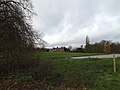
 Field looking towards Park Farm - geograph.org.uk - 4952585.jpg 3,264 × 1,840; 2.29 MB
-
 Field near Beck Brook Farm - geograph.org.uk - 4951290.jpg 3,264 × 1,840; 2.17 MB
-
 Fields by Cambridge Road, Madingley - geograph.org.uk - 6476421.jpg 1,920 × 1,280; 1.76 MB
-
 Fish Pond at Madingley Hall - geograph.org.uk - 4286206.jpg 3,072 × 2,304; 1.94 MB
-

-
 Footpath and stubble field - geograph.org.uk - 4740488.jpg 2,560 × 1,920; 1.72 MB
-
 Footpath seen from Dry Drayton Road - geograph.org.uk - 3344272.jpg 4,000 × 3,000; 4.14 MB
-
 Footpath through Madingley Wood - geograph.org.uk - 3150757.jpg 1,024 × 779; 1.42 MB
-
 Footpath to Dry Drayton - geograph.org.uk - 3344310.jpg 4,000 × 3,000; 4.18 MB
-
 Footpath to Huntingdon Road - geograph.org.uk - 3344271.jpg 4,000 × 3,000; 4.07 MB
-
 Gate to muddy field on the outskirts of Madingley - geograph.org.uk - 3344262.jpg 4,000 × 3,000; 4.45 MB
-
 Girton, nearing Junction 14 - geograph.org.uk - 4593855.jpg 1,024 × 731; 965 KB
-
 Girton, under the junction - geograph.org.uk - 4593785.jpg 1,024 × 732; 1.09 MB
-
 Grass Fields next to Whitepits Plantation - geograph.org.uk - 4952593.jpg 3,264 × 1,840; 2.65 MB
-
 Graves at Cambridge American Military Cemetery, Madingley - geograph.org.uk - 6286332.jpg 4,000 × 3,000; 4.79 MB
-
 Hedge and farmland - geograph.org.uk - 5367597.jpg 640 × 426; 67 KB
-
 High Street sign - geograph.org.uk - 4286093.jpg 3,072 × 2,304; 1.93 MB
-
 High Street, Madingley - geograph.org.uk - 3680822.jpg 640 × 480; 301 KB
-
 High Street, Madingley - geograph.org.uk - 4286145.jpg 3,072 × 2,304; 1.84 MB
-
 High Street, Madingley - geograph.org.uk - 4772440.jpg 1,280 × 851; 369 KB
-
 High Street, Madingley - geograph.org.uk - 6064079.jpg 1,024 × 684; 296 KB
-
 Home Farm, Madingley - geograph.org.uk - 1042720.jpg 640 × 480; 95 KB
-
 House on The Avenue - geograph.org.uk - 4737448.jpg 2,560 × 1,920; 1.56 MB
-
 Houses off St Neots Road - geograph.org.uk - 705082.jpg 640 × 480; 81 KB
-

-

-
 Layby on A1302 - geograph.org.uk - 2670292.jpg 640 × 424; 63 KB
-
 Leaving Madingley - geograph.org.uk - 1070015.jpg 640 × 480; 136 KB
-
 Little Shrubs - geograph.org.uk - 1043202.jpg 640 × 480; 190 KB
-
 Looking across Madingley American Cemetery - geograph.org.uk - 2396586.jpg 1,280 × 960; 647 KB
-

-

-
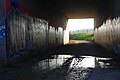 Looking under the M11 - geograph.org.uk - 5343183.jpg 3,872 × 2,592; 2.72 MB
-
 M11 at junction 14 - geograph.org.uk - 2641504.jpg 640 × 428; 90 KB
-
 M11 at junction 14 - geograph.org.uk - 3458813.jpg 1,683 × 1,024; 921 KB
-
 M11 end of Motorway 1 mile - geograph.org.uk - 3458803.jpg 1,413 × 859; 644 KB
-
 M11 from Brook Leys - geograph.org.uk - 5931425.jpg 1,600 × 1,129; 403 KB
-
 M11 junction 14 - geograph.org.uk - 2641481.jpg 640 × 428; 96 KB
-
 M11, Junction 14 - geograph.org.uk - 5839257.jpg 2,956 × 2,220; 2.99 MB
-
 M11, south of J14 - geograph.org.uk - 4811598.jpg 640 × 426; 28 KB
-
 M11, southbound - geograph.org.uk - 4811600.jpg 640 × 332; 25 KB
-
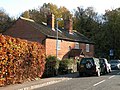
 Madingley - 16-18 Cambridge Road.jpg 4,032 × 3,024; 4.73 MB
-
 Madingley - 31 High Street.jpg 4,032 × 3,024; 4.84 MB
-
 Madingley - American Cemetery - geograph.org.uk - 3522992.jpg 640 × 427; 84 KB
-
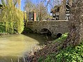 Madingley - bridge to Madingley Hall.jpg 4,032 × 3,024; 6.41 MB
-
 Madingley - Brook House.jpg 4,032 × 3,024; 7.09 MB
-
 Madingley - Lodge at entrance to Madingley Hall - geograph.org.uk - 4221513.jpg 1,333 × 1,000; 1.18 MB
-
 Madingley - Lodge to Madingley Hall.jpg 4,032 × 3,024; 5.23 MB
-
 Madingley - Madingley Hall - geograph.org.uk - 4222402.jpg 1,685 × 1,000; 1.19 MB
-
 Madingley - Manor House.jpg 4,032 × 3,024; 3.11 MB
-
 Madingley Church - geograph.org.uk - 4285935.jpg 3,072 × 2,304; 1.84 MB
-
 Madingley Church and Hall entrance - geograph.org.uk - 986949.jpg 640 × 427; 89 KB
-
 Madingley Hall - geograph.org.uk - 2544864.jpg 640 × 480; 164 KB
-
 Madingley Hall - geograph.org.uk - 4212002.jpg 1,000 × 708; 326 KB
-
 Madingley Hall - geograph.org.uk - 4286139.jpg 3,072 × 2,304; 1.79 MB
-
 Madingley Hall - geograph.org.uk - 4286196.jpg 3,072 × 2,304; 1.8 MB
-
 Madingley Hall and lake - geograph.org.uk - 3278295.jpg 1,024 × 753; 219 KB
-
 Madingley Hall and lake on St David's Day - geograph.org.uk - 6402214.jpg 1,024 × 768; 973 KB
-
 Madingley Hall at dusk - geograph.org.uk - 6688001.jpg 1,024 × 668; 79 KB
-
 Madingley Hall from the east - geograph.org.uk - 6687998.jpg 1,024 × 711; 214 KB
-
 Madingley Hall lake - geograph.org.uk - 3278281.jpg 935 × 1,200; 1.21 MB
-
 Madingley Hall lake - geograph.org.uk - 6742886.jpg 1,024 × 768; 946 KB
-
 Madingley Hall Postbox - geograph.org.uk - 4286163.jpg 3,072 × 2,304; 1.96 MB
-
 Madingley Hall Postbox - geograph.org.uk - 4286166.jpg 2,304 × 3,072; 3.61 MB
-
 Madingley Hall Postbox - geograph.org.uk - 4286179.jpg 2,304 × 3,072; 2.94 MB
-
 Madingley Hall Postbox - geograph.org.uk - 4286187.jpg 2,304 × 3,072; 3.57 MB
-
 Madingley Hall reflected - geograph.org.uk - 3278268.jpg 1,024 × 742; 258 KB
-
 Madingley Hall seen across the lake - geograph.org.uk - 3344425.jpg 4,000 × 3,000; 4.11 MB
-
 Madingley Hall under scaffolding - geograph.org.uk - 6680598.jpg 1,024 × 683; 150 KB
-
 Madingley Hall, avenue - geograph.org.uk - 3278150.jpg 1,024 × 1,024; 577 KB
-
 Madingley Hall, Madlingley, Cambridge - geograph.org.uk - 6687342.jpg 4,000 × 3,000; 4.9 MB

_p1.017_-_Madingley_Bridge_and_Church.jpg)


