Category:Maitland Church, Oxton
Jump to navigation
Jump to search
| Object location | | View all coordinates using: OpenStreetMap |
|---|
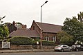
Evangelical church on Storeton Road, Oxton.
Media in category "Maitland Church, Oxton"
The following 3 files are in this category, out of 3 total.
-
 Maitland Church, Oxton 1.jpg 4,894 × 3,433; 19.65 MB
-
 Maitland Church, Oxton 2.jpg 5,037 × 3,368; 21.1 MB
-
 Maitland Church, Oxton 3.jpg 4,878 × 3,257; 19.23 MB


