Category:Manor house in Żydów
Jump to navigation
Jump to search
| Object location | | View all coordinates using: OpenStreetMap |
|---|
zespół dworski:
- dwór, poł. XIX, 1912:
- park, XIX, 1 cw. XX:
- spichrz, 1880, nr rej.: j.w.
- stodoła, 1887, nr rej.: j.w.
Media in category "Manor house in Żydów"
The following 8 files are in this category, out of 8 total.
-
 IGP0477dwór z połowy XIX w. wybudowany przez Emila Fulde.JPG 2,848 × 4,288; 4.89 MB
-
 IGP0516 neogotycka stodoła z z1887, wybudowana przeza Aleksandra Golembowskiego.JPG 3,491 × 2,361; 6.21 MB
-
 IGP0647 dwór z połowy XIX w. wybudowany w 1912 przez Emila Fulde.JPG 3,331 × 2,161; 5.57 MB
-
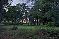 IGP0648 park z XIX i XX w..JPG 4,288 × 2,848; 10.71 MB
-
 IGP0655 dwór z połowy XIX w. wybudowany w 1912 przez Emila Fulde.JPG 3,483 × 2,111; 3.23 MB
-
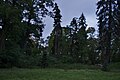 IGP0656 park z XIX i XX w..JPG 4,288 × 2,848; 7.98 MB
-
 IGP0661 (2) dwór z połowy XIX w wybudowany w 1912 przez Emila Fulde.jpg 3,508 × 2,344; 5.44 MB
-
 IGP0667 dwór z połwy XIX w. , wybudowany przez Emila Fulde.JPG 2,726 × 4,210; 6.52 MB


_dw%C3%B3r_z_po%C5%82owy_XIX_w_wybudowany_w_1912_przez_Emila_Fulde.jpg)
