Category:Mapperley, Derbyshire
Jump to navigation
Jump to search
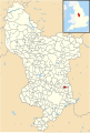
English: Mapperley is a village and civil parish in the Amber Valley district of Derbyshire, England, situated northwest of Ilkeston. In the 2001 census it had a population of 253.
village and civil parish in Amber Valley district, Derbyshire  | |||||
| Upload media | |||||
| Instance of | |||||
|---|---|---|---|---|---|
| Location | Amber Valley, Derbyshire, East Midlands, England | ||||
 | |||||
Subcategories
This category has only the following subcategory.
Media in category "Mapperley, Derbyshire"
The following 84 files are in this category, out of 84 total.
-
 28-29 Church Lane, Mapperley.jpg 1,280 × 960; 318 KB
-
 Access for farm and frontiers only - geograph.org.uk - 5477593.jpg 1,280 × 960; 501 KB
-
 Approaching Mapperley Village - geograph.org.uk - 2639395.jpg 640 × 480; 54 KB
-

-
 Barbed wired gate with signs - geograph.org.uk - 3249375.jpg 3,648 × 2,736; 4.79 MB
-
 Barn at Mapperley Park - geograph.org.uk - 5477587.jpg 1,280 × 960; 326 KB
-
 Beech stump - geograph.org.uk - 277770.jpg 480 × 640; 343 KB
-
 Bench mark, Mapperley Park - geograph.org.uk - 5477585.jpg 1,280 × 1,280; 621 KB
-
 Bridge and farm track near Head House Farm - geograph.org.uk - 5482864.jpg 1,280 × 944; 358 KB
-
 Brook by the Nutbrook Trail - geograph.org.uk - 1305578.jpg 640 × 480; 218 KB
-
 Brook Rushes - geograph.org.uk - 1302056.jpg 640 × 480; 202 KB
-
 Church of Holy Trinity, Mapperley - geograph.org.uk - 5477603.jpg 872 × 1,280; 350 KB
-
 Church of Holy Trinity, Mapperley - geograph.org.uk - 5477604.jpg 912 × 1,280; 342 KB
-
 Church of Holy Trinity, Mapperley - geograph.org.uk - 5477606.jpg 837 × 1,280; 341 KB
-
 Church of Holy Trinity, Mapperley - geograph.org.uk - 5477608.jpg 928 × 1,280; 304 KB
-
 Church of Holy Trinity, Mapperley - geograph.org.uk - 5477611.jpg 1,280 × 960; 376 KB
-
 Church of Holy Trinity, Mapperley - geograph.org.uk - 5477614.jpg 1,280 × 1,280; 533 KB
-
 Church of Holy Trinity, Mapperley - geograph.org.uk - 5477617.jpg 928 × 1,280; 367 KB
-
 Church of Holy Trinity, Mapperley - geograph.org.uk - 5477619.jpg 960 × 1,280; 542 KB
-
 Cottages, Mapperley Park - geograph.org.uk - 3249637.jpg 3,648 × 2,736; 4.76 MB
-
 Course of old railway line - geograph.org.uk - 3249986.jpg 3,648 × 2,736; 4.77 MB
-
 Derbyshire UK parish map highlighting Mapperley.svg 888 × 1,308; 2.34 MB
-
 Entrance to Manor Farm - geograph.org.uk - 5477595.jpg 1,280 × 861; 308 KB
-
 Entrance to Park Hall Farm - geograph.org.uk - 3249413.jpg 3,648 × 2,736; 4.94 MB
-
 Flooding on Park Lane - geograph.org.uk - 3820201.jpg 4,000 × 3,000; 2.43 MB
-
 Footpath at Mapperley Park - geograph.org.uk - 5477586.jpg 1,280 × 960; 340 KB
-
 Footpath near Mapperley Park - geograph.org.uk - 5456801.jpg 1,280 × 960; 487 KB
-
 Former Royal Oak pub, Mapperley Park - geograph.org.uk - 5477591.jpg 1,280 × 919; 321 KB
-
 Ilkeston Track - geograph.org.uk - 1302060.jpg 640 × 480; 274 KB
-
 Lodge House Opencast Mine, aerial 2014 (2) - geograph.org.uk - 3925971.jpg 1,024 × 597; 90 KB
-
 Looking north to Heanor - geograph.org.uk - 3249645.jpg 3,648 × 2,736; 4.7 MB
-
 Lychgate, Holy Trinity Church, Mapperley.jpg 960 × 1,280; 450 KB
-
 Mapperley Colliery Branch - geograph.org.uk - 1050471.jpg 640 × 428; 133 KB
-
 Mapperley Dam - geograph.org.uk - 5742681.jpg 2,000 × 1,333; 3.61 MB
-
 Mapperley field at Head House farm - geograph.org.uk - 1305561.jpg 640 × 480; 186 KB
-
 Mapperley Lane railway bridge - geograph.org.uk - 5456785.jpg 1,280 × 960; 695 KB
-
 Mapperley Park - geograph.org.uk - 1050381.jpg 640 × 428; 104 KB
-
 Mapperley Park Farmhouse and Cottage.jpg 1,280 × 869; 345 KB
-
 Mapperley Reservoir - geograph.org.uk - 1041723.jpg 640 × 426; 89 KB
-
 Mapperley Reservoir - geograph.org.uk - 1041772.jpg 640 × 426; 75 KB
-
 Mapperley Reservoir - geograph.org.uk - 2639375.jpg 640 × 480; 55 KB
-
 Mapperley Reservoir - geograph.org.uk - 5361397.jpg 2,000 × 1,333; 1.76 MB
-
 Mapperley reservoir - geograph.org.uk - 5742679.jpg 2,000 × 1,333; 2.89 MB
-
 Mapperley Reservoir - geograph.org.uk - 6239135.jpg 640 × 480; 118 KB
-
 Mapperley Reservoir dam - 1 - geograph.org.uk - 1998822.jpg 800 × 585; 142 KB
-
 Mapperley Reservoir outflow - geograph.org.uk - 1998840.jpg 600 × 800; 125 KB
-
 Mapperley Reservoir spillway - geograph.org.uk - 6239137.jpg 480 × 640; 126 KB
-
 Mapperley stile at Head House farm - geograph.org.uk - 1305557.jpg 640 × 480; 200 KB
-
 Mapperley village - geograph.org.uk - 1302077.jpg 640 × 480; 184 KB
-
 Mapperley village - geograph.org.uk - 1305539.jpg 640 × 480; 213 KB
-
 Mapperley Village - geograph.org.uk - 3820263.jpg 3,315 × 2,178; 1.12 MB
-
 Mapperley Village Lych Gate 1305547 a82561da.jpg 640 × 480; 219 KB
-
 Mapperley village trees - geograph.org.uk - 1305549.jpg 640 × 480; 168 KB
-
 Mapperly Park Wood - geograph.org.uk - 6239142.jpg 480 × 640; 178 KB
-
 Mapperly trees - geograph.org.uk - 1302065.jpg 640 × 480; 173 KB
-
 Mapperly trees - geograph.org.uk - 1302068.jpg 640 × 480; 200 KB
-
 Muddy Brook - geograph.org.uk - 1305564.jpg 640 × 480; 233 KB
-
 Nut Brook or Nutbrook Canal - geograph.org.uk - 3623202.jpg 640 × 480; 245 KB
-
 Park Hall Cottages at Mapperley Park - geograph.org.uk - 3820206.jpg 3,810 × 2,728; 1.88 MB
-
 Park Hall Farm - geograph.org.uk - 3249408.jpg 3,648 × 2,736; 4.98 MB
-
 Park Hall Lane, Mapperley Park - geograph.org.uk - 1050370.jpg 640 × 428; 131 KB
-
 Path and view to Head House Farm - geograph.org.uk - 3623220.jpg 640 × 480; 153 KB
-
 Path next to the Nutbook Trail - geograph.org.uk - 1305575.jpg 640 × 480; 193 KB
-
 Path next to the Nutbook Trail - geograph.org.uk - 1305580.jpg 640 × 480; 203 KB
-
 Reservoir Cottage - geograph.org.uk - 1041752.jpg 640 × 426; 147 KB
-
 Settling ponds outlet, Shipley Common - geograph.org.uk - 5482861.jpg 1,280 × 960; 444 KB
-
 Shipley Lane Mapperley - geograph.org.uk - 1041582.jpg 640 × 426; 128 KB
-
 Simonfield, farm buildings - geograph.org.uk - 3249387.jpg 3,648 × 2,736; 4.32 MB
-
 Simple footbridge over an unnamed brook - geograph.org.uk - 6239146.jpg 640 × 480; 156 KB
-
 Stile with water feature - geograph.org.uk - 3249396.jpg 2,736 × 3,648; 4.79 MB
-
 The Old Black Horse - geograph.org.uk - 6239139.jpg 640 × 480; 96 KB
-
 The Old Black Horse, Mapperley - geograph.org.uk - 5477597.jpg 1,280 × 993; 296 KB
-
 Tree Line - geograph.org.uk - 1302063.jpg 640 × 480; 181 KB
-
 Used car lot - geograph.org.uk - 3249979.jpg 3,648 × 2,736; 5.01 MB
-
 View towards Mapperley - geograph.org.uk - 5456792.jpg 1,280 × 960; 295 KB
-
 Well cared for footpaths - geograph.org.uk - 5742685.jpg 2,000 × 1,455; 3.35 MB
-
 What you doing in MY field^ - geograph.org.uk - 1305550.jpg 640 × 480; 202 KB
-
 Wooden structure in Mapperly Park Wood - geograph.org.uk - 6239145.jpg 480 × 640; 163 KB
-
 Between West Hallam and Mapperley - geograph.org.uk - 15489.jpg 640 × 480; 95 KB
-
 Japanese maple, Shipley Country Park - geograph.org.uk - 277781.jpg 640 × 480; 366 KB
-
 Road through Shipley Country Park - geograph.org.uk - 277811.jpg 640 × 480; 327 KB
-
 Rowan, Shipley Hill - geograph.org.uk - 277808.jpg 640 × 480; 354 KB
-
 Shipley Hill south side - geograph.org.uk - 277816.jpg 630 × 480; 351 KB
-
 View over Shipley Park - geograph.org.uk - 277818.jpg 640 × 480; 261 KB


_-_geograph.org.uk_-_3925971.jpg)


