Category:Maps by Jacob van Meurs
Jump to navigation
Jump to search
Media in category "Maps by Jacob van Meurs"
The following 41 files are in this category, out of 41 total.
-
 Africae accurata tabula ex officina Jacobum Meursium RMG F0250.tiff 7,221 × 5,762; 119.04 MB
-
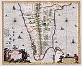 AMH-5639-KB Map of southern India.jpg 2,400 × 1,932; 696 KB
-
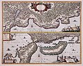
 AMH-5641-KB Map of Batavia and environs.jpg 2,400 × 1,941; 672 KB
-
 AMH-5649-KB Map depicting the journey by Joan Nieuhoff from Canton to Peking.jpg 2,400 × 2,024; 682 KB
-
 AMH-5651-KB Map of Japan.jpg 2,400 × 1,915; 822 KB
-
 AMH-5654-KB Map of South Africa and a view of Table Bay.jpg 2,400 × 1,928; 640 KB
-
 AMH-6608-KB Map of the Arabian Peninsula.jpg 2,400 × 1,972; 1.31 MB
-
 AMH-6722-KB Map of North and South America.jpg 2,400 × 1,918; 1.04 MB
-
 AMH-6723-KB Map of the New Netherlands.jpg 2,400 × 1,933; 1.33 MB
-
 AMH-6725-KB Map of the Caribbean region.jpg 2,400 × 1,916; 1.19 MB
-
 AMH-6828-KB Map of Guiana.jpg 2,400 × 1,941; 1.02 MB
-
 AMH-6829-KB Map of Venezuela.jpg 2,400 × 1,963; 1.15 MB
-
 AMH-6830-KB Map of the coast of Chile.jpg 2,400 × 1,946; 1.03 MB
-
 AMH-6838-KB View of the northern part of India.jpg 2,400 × 2,001; 1.14 MB
-
 AMH-6843-KB Map of Persia.jpg 2,400 × 1,997; 1.22 MB
-
 AMH-6853-KB Map of the west coast of Africa.jpg 2,400 × 1,773; 1.06 MB
-
 AMH-6854-KB Map of Guinea.jpg 2,400 × 1,765; 987 KB
-
 AMH-6860-KB Map of Southern Africa.jpg 2,400 × 1,906; 1.05 MB
-
 AMH-6862-KB Map of south west Africa.jpg 2,400 × 2,034; 1 MB
-
 AMH-6865-KB Map of East Africa.jpg 2,400 × 1,923; 1.1 MB
-
 AMH-6870-KB Bird's eye view of St. Helena.jpg 2,400 × 1,903; 1.17 MB
-
 AMH-6873-KB Map of Madagascar.jpg 2,400 × 1,899; 918 KB
-
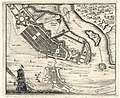 AMH-6921-KB Map of Recife and Mauritsstad.jpg 2,400 × 1,968; 1.21 MB
-
 AMH-6925-KB Map of Olinda.jpg 2,400 × 1,983; 1.24 MB
-
 AMH-6926-KB Map of the Cape of Good Hope.jpg 2,400 × 1,911; 975 KB
-
 AMH-6928-KB Map of South India.jpg 2,400 × 1,936; 1,020 KB
-
 AMH-6931-KB View of the Nieuwe Poort on Batavia.jpg 2,400 × 1,865; 1,022 KB
-
 AMH-6932-KB Map of Batavia and environs.jpg 2,400 × 1,948; 1.04 MB
-
 AMH-6944-KB Map of the islands off the coast of Batavia.jpg 2,400 × 1,821; 825 KB
-
 AMH-7748-KB Map of Brazil.jpg 2,400 × 1,984; 1.13 MB
-

-

-

-

-

-
 Het Gast Huys, objectnr A 37972.tif 3,508 × 2,476; 21.53 MB
-
 Illustratie voor 'Den Arbeid van Mars' van Allain Manesson Mallet, RP-P-1913-6052.jpg 3,744 × 6,666; 5.08 MB
-

-
 Map of the region bounded by the Saudi Peninsula, Red Sea.jpg 2,749 × 2,376; 7.69 MB
-

-


.jpg)

_De_Brittenburg_bij_Katwijk,_RP-P-AO-10-45C.jpg)


