Category:Maps of 15th-century Iberian Peninsula
Jump to navigation
Jump to search
| Preceded by: Maps of 14th-century Iberian Peninsula |
Maps of 15th-century Iberian Peninsula 1401 AD-1500 AD |
Succeeded by: Maps of 16th-century Iberian Peninsula |
Subcategories
This category has only the following subcategory.
S
- Maps of 15th-century Spain (13 F)
Media in category "Maps of 15th-century Iberian Peninsula"
The following 11 files are in this category, out of 11 total.
-
 España 1492.jpg 237 × 212; 9 KB
-
 Modern history; Europe (1904) (14763413054).jpg 1,928 × 2,888; 1.74 MB
-
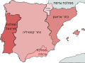 Iberian Kingdoms in 1400-he.svg 738 × 542; 987 KB
-
 Iberian Kingdoms in 1400.svg 738 × 542; 971 KB
-
 Map of Spain 1490.jpg 1,637 × 1,504; 224 KB
-
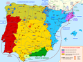
 Orders of knighthood Iberia.svg 1,749 × 1,359; 1.5 MB
-
 Peninsula Iberica 1400.png 738 × 542; 77 KB
-
 Péninsule ibérique en 1410.png 2,000 × 1,500; 897 KB
-
 Péninsule ibérique en 1450.png 2,000 × 1,500; 839 KB
-
 Péninsule ibérique en 1479.png 2,000 × 1,500; 1,012 KB
-
 Reinos Antiguo Régimen.jpg 738 × 542; 111 KB

_(14763413054).jpg)


