Category:Maps of 5th-century BC India
Jump to navigation
Jump to search
Countries of Asia: India
Media in category "Maps of 5th-century BC India"
The following 11 files are in this category, out of 11 total.
-
 Ancient Republics(Ganarajya or Gansangha).png 861 × 375; 415 KB
-
 Gana Sanghas (c. 500 BCE).jpg 1,630 × 1,000; 1.76 MB
-
 Magadha early expansion.gif 1,500 × 891; 1.85 MB
-
 Magadha Expansion 1.gif 680 × 593; 2.78 MB
-
 Magadha Expansion 2.gif 680 × 593; 2.21 MB
-
 Map of North-India during the Avanti-Magadhan Wars.png 8,000 × 4,500; 2.64 MB
-
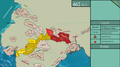
 The eastern Gangetic plain after Ajatasattu's conquest of Kosala.jpg 1,500 × 891; 2.36 MB
-
-
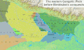
 The eastern Gangetic plain after Bimbisara's conquests.jpg 1,500 × 891; 2.36 MB
-
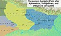
 The eastern Gangetic plain before Bimbisara's conquests.jpg 1,500 × 891; 2.36 MB
-
 தெற்காசிய வரைபடம் கி. பி. 450.svg 512 × 481; 394 KB
.png)
.jpg)


