Category:Maps of Camden, Ohio
Jump to navigation
Jump to search
Subcategories
This category has only the following subcategory.
Media in category "Maps of Camden, Ohio"
The following 7 files are in this category, out of 7 total.
-
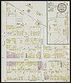 Camden, Preble County, Ohio, 1895 - DPLA - dd8b7f4f9b56fe220ac6c48ca0b50207 (page 1).jpeg 6,595 × 7,779; 9.49 MB
-
 Camden, Preble County, Ohio, 1895 - DPLA - dd8b7f4f9b56fe220ac6c48ca0b50207 (page 2).jpeg 6,563 × 7,779; 8.79 MB
-
 Camden, Preble County, Ohio, 1911 - DPLA - 01af0ba7935c1dd011f8ae3ba92d9124 (page 1).jpeg 6,582 × 7,836; 9.34 MB
-
 Camden, Preble County, Ohio, 1911 - DPLA - 01af0ba7935c1dd011f8ae3ba92d9124 (page 2).jpeg 6,601 × 7,798; 9.22 MB
-
 Camden, Preble County, Ohio, 1911 - DPLA - 01af0ba7935c1dd011f8ae3ba92d9124 (page 3).jpeg 6,620 × 7,817; 8.29 MB
-
 Map of Preble County Ohio Highlighting Camden Village.png 411 × 559; 20 KB
-
 OHMap-doton-Camden.png 274 × 300; 10 KB
.jpeg)
.jpeg)
.jpeg)
.jpeg)
.jpeg)

