Category:Maps of Chaon (Loir-et-Cher)
Jump to navigation
Jump to search
Subcategories
This category has only the following subcategory.
Media in category "Maps of Chaon (Loir-et-Cher)"
The following 6 files are in this category, out of 6 total.
-
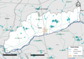 41036-Chaon-Cours eau.png 3,507 × 2,480; 1.35 MB
-
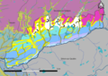 41036-Chaon-géologie.png 7,015 × 4,960; 4.39 MB
-
 41036-Chaon-Natura2000-SIC.png 3,507 × 2,480; 1.31 MB
-
 41036-Chaon-Natura2000-ZPS.png 3,507 × 2,480; 1.31 MB
-
 41036-Chaon-Zone inondable.png 3,507 × 2,480; 1.21 MB
-
 Map commune FR insee code 41036.png 756 × 605; 69 KB


