Category:Maps of Grey County
Jump to navigation
Jump to search
Wikimedia category | |||||
| Upload media | |||||
| Instance of | |||||
|---|---|---|---|---|---|
| Category combines topics | |||||
| Grey County | |||||
county of the Canadian province of Ontario  | |||||
| Instance of |
| ||||
| Location | Ontario, Canada | ||||
| Headquarters location |
| ||||
| Inception |
| ||||
| Population |
| ||||
| official website | |||||
 | |||||
Media in category "Maps of Grey County"
The following 20 files are in this category, out of 20 total.
-
 Griffith Island, Georgian Bay.png 847 × 602; 70 KB
-
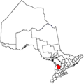
 Map of Ontario GREY.svg 340 × 330; 84 KB
-
 Ontgre.png 378 × 379; 9 KB
-
 Owen Sound, Grey County, Ontario, 1880.jpg 522 × 351; 143 KB
-
 Township of Artemesia, Grey County, Ontario, 1880.jpg 3,336 × 3,470; 3.93 MB
-
 Township of Bentinck, Grey County, Ontario, 1880.jpg 3,254 × 3,334; 3.75 MB
-
 Township of Derby, Grey County, Ontario, 1880.jpg 3,594 × 3,228; 3.57 MB
-
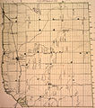 Township of Egremont, Grey County, Ontario, 1880.jpg 3,278 × 3,726; 3.69 MB
-
 Township of Euphrasia, Grey County, Ontario, 1880.jpg 3,280 × 3,860; 4.84 MB
-
 Township of Glenelg, Grey County, Ontario, 1880.jpg 3,304 × 3,436; 3.82 MB
-
 Township of Holland, Grey County, Ontario, 1880.jpg 3,148 × 3,516; 3.81 MB
-
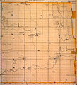
 Township of Normanby, Grey County, Ontario, 1880 -- watercourses traced in blue.jpg 3,324 × 3,226; 2.64 MB
-
 Township of Normanby, Grey County, Ontario, 1880.jpg 3,324 × 3,226; 2.61 MB
-
 Township of Osprey, Grey County, Ontario, 1880.jpg 3,386 × 3,602; 4.48 MB
-
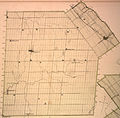 Township of Proton, Grey County, Ontario, 1880.jpg 3,300 × 3,236; 3.71 MB
-
 Township of Sarawak and Keppel, Grey County, Ontario, 1880.jpg 3,017 × 4,328; 4.09 MB
-
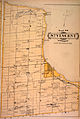 Township of St. Vincent, Grey County, Ontario, 1880.jpg 2,865 × 4,272; 4.01 MB
-
 Township of Sullivan, Grey County, Ontario, 1880.jpg 3,140 × 3,450; 4.15 MB
-
 Township of Sydenham, Grey County, Ontario, 1880.jpg 3,083 × 4,320; 4.6 MB
-
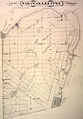
 Townships of Grey County, Ontario, 1880.jpg 529 × 720; 191 KB


