Category:Maps of Hudson Bay
Jump to navigation
Jump to search
Wikimedia category | |||||
| Upload media | |||||
| Instance of | |||||
|---|---|---|---|---|---|
| Category combines topics | |||||
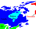
| Hudson Bay | |||||
large body of saltwater in northeastern Canada that drains much of north-central North America   | |||||
| Instance of |
| ||||
| Part of | |||||
| Named after | |||||
| Location | |||||
| Has part(s) | |||||
| Width |
| ||||
| Area |
| ||||
| Mouth of the watercourse | |||||
| Inflows |
| ||||
| Drainage basin | |||||
| Different from | |||||
 | |||||
Subcategories
This category has only the following subcategory.
O
Media in category "Maps of Hudson Bay"
The following 47 files are in this category, out of 47 total.
-
-
 A biological investigation of the Hudson Bay region (1902) (20146393603).jpg 2,238 × 3,466; 1.94 MB
-
 A biological investigation of the Hudson Bay region (1902) (20371644422).jpg 2,634 × 4,100; 2.61 MB
-

-
 Admiralty Chart Catalogue 1967 Page 116 Index U1.jpg 8,568 × 6,834; 8.22 MB
-
 Arc Nastapoka.png 825 × 685; 131 KB
-
 Cape Fullerton.png 1,500 × 921; 372 KB
-
 Fond de la baie d'Hudson avec les fort anglais pris par les Français en 1686.jpg 4,568 × 4,449; 5.38 MB
-
 Hudson bay explorer.png 550 × 442; 449 KB
-
 Hudson Bay in its region.svg 500 × 281; 4.83 MB
-
 Hudson bay large (he).svg 429 × 425; 136 KB
-
 Hudson bay large mk.svg 429 × 425; 1,000 KB
-
 Hudson bay large sr.svg 429 × 425; 122 KB
-
 Hudson bay large uk.png 2,000 × 1,981; 359 KB
-
 Hudson bay large.png 1,423 × 1,378; 224 KB
-
 Hudson bay large.svg 429 × 425; 122 KB
-
 Hudson bay map-es.svg 998 × 822; 361 KB
-
 Hudson bay map-fr.svg 998 × 822; 233 KB
-
 Hudson bay map-it.svg 998 × 822; 235 KB
-
 Hudson Bay Route Plan of Churchill Harbour (1927).jpg 4,008 × 7,483; 9 MB
-
 Hudson Bay Route Plan of the Nelson Estuary (1927).jpg 7,516 × 3,784; 10.55 MB
-
 Hudson Bay Route Possible Port Terminal at Churchill (1927).jpg 8,992 × 3,773; 12.42 MB
-
 Hudson Bay Route Possible Port Terminal at Port Nelson (1927).jpg 6,228 × 3,762; 8.7 MB
-
 Hudson Bay Shape.svg 463 × 600; 488 KB
-
 Hudsonbai.PNG 457 × 376; 51 KB
-
 Hudsonbay-ar.png 457 × 376; 59 KB
-
 Hudsonbay.png 457 × 376; 60 KB
-
 HudsonBay.PNG 211 × 169; 4 KB
-
 HudsonbayChS.png 457 × 376; 56 KB
-
 Islands near chesterfield inlet.jpg 1,655 × 2,057; 352 KB
-
 Longislandnunavut.png 457 × 376; 60 KB
-
 LongIslandNunavut.png 540 × 276; 6 KB
-
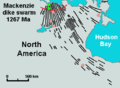 Mackenzie dike swarm.png 384 × 283; 9 KB
-
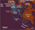 Mackenzie Large Igneous Province.png 550 × 485; 255 KB
-
 Map of Hudson Bay - DPLA - 3b66b3817469113669c3e28a21f4ff38.jpg 7,936 × 7,488; 3.95 MB
-

-
 Matachewan and Mistassini dike swarms.png 417 × 308; 12 KB
-
 MLIP igneous figures.png 510 × 403; 35 KB
-
 Moses Norton’s Draught of the Northern Parts of Hudsons Bay 1760 (1969).jpg 2,544 × 2,997; 1.24 MB
-
 Operational Navigation Chart C-11, 2nd edition.jpg 9,254 × 6,640; 19.27 MB
-
 Operational Navigation Chart C-12, 4th edition.jpg 9,254 × 6,705; 17.03 MB
-
 Operational Navigation Chart D-14, 5th edition.jpg 9,254 × 6,680; 17.19 MB
-
 SealRiverManitoba.png 483 × 595; 130 KB
-

-
 The Hudson Bay Route as an Outlet for Canadian Wheat (1917).jpg 3,219 × 1,993; 3.16 MB
-
 Ukkusiksalik NP 2006-03-11.jpg 4,056 × 2,328; 297 KB
-
 Ukkusiksalik NP Ansgar+CAN.jpg 4,654 × 2,734; 626 KB
%27_(11243501224).jpg)
_(20146393603).jpg)
_(20371644422).jpg)
.jpg)


.svg)


.jpg)
.jpg)
.jpg)
.jpg)


._Drawn..._;_by_P.Fr%C3%A9reault_-_btv1b53070688j.jpg)


.jpg)


_(14592330490).jpg)
.jpg)

