<nowiki>Category:Maps of Kandahar; categoría de Wikimedia; kategori Wikimedia; Wikimedia category; د ويکيمېډيا وېشنيزه; Vikimedya kategorisi; ویکیمیڈیا زمرہ; kategória projektov Wikimedia; категорія проєкту Вікімедіа; 维基媒体分类; Wikimedia-Kategorie; Викимедиина категорија; Wikimedia-Kategorie; विकिपीडिया:श्रेणी; page de catégorie de Wikimedia; kategorija na Wikimediji; विकिपीडिया वर्ग; категорија на Викимедији; Wikimedia-Kategorie; Wikimedia-kategori; kategori Wikimédia; تصنيف ويكيميديا; pajenn rummata eus Wikimedia; Wikimedia:ကဏ္ဍခွဲခြင်း; 維基媒體分類; Wikimedia категориясы; categoría de Wikimedia; Wikimedia-Kategorie; Wikimedia-Kategorie; tudalen categori Wikimedia; Viciméid catagóir; Վիքիմեդիայի նախագծի կատեգորիա; 维基媒体分类; Wikimedia-kategory; ვიკიპედია:კატეგორიზაცია; ウィキメディアのカテゴリ; categoria Wikimedia; تصنيف بتاع ويكيميديا; විකිමීඩියා ප්රභේද පිටුව; categoria Vicimediorum; विकिमीडिया श्रेणी; Wikimedia-luokka; Wikimedia category; guruhi Vikimedia; катэгорыя ў праекце Вікімэдыя; Викимедиа проектындагы төркем; catigurìa di nu pruggettu Wikimedia; หน้าหมวดหมู่วิกิมีเดีย; Wikimedia:Kategorija; Wikimedia-Kategorie; Wikimedia:Klassys; категория на Уикимедия; categorie a unui proiect Wikimedia; 維基媒體分類; Wikimedia-kategori; kawan Wikimèdia; 維基媒體分類; 위키미디어 분류; Wikimedia-bólkur; kategorio en Vikimedio; kategori Wikimedia; Wikimedia:Ronnaghys; উইকিমিডিয়া বিষয়শ্রেণী; kategori Wikimedia; 维基媒体分类; וויקימעדיע קאַטעגאָריע; kategorija w projektach Wikimedije; thể loại Wikimedia; Wikimedia projekta kategorija; kategoria ti Wikimedia; categoria de um projeto da Wikimedia; 维基媒体分类; категорияд Ангилал; Wikimedia-kategori; kategori Wikimedia; پۆلی ویکیمیدیا; Wikimedia category; Vikimédia ñemohenda; Wikimédia-kategória; વિકિપીડિયા શ્રેણી; Wikimediako kategoria; категория в проекте Викимедиа; Wikimedia-Kategorie; катэгорыя ў праекце Вікімедыя; Wikimedia-kategorie; Wîkîmediya:Kategorî; विकिमिडिया श्रेणी; Wikimedia-Kategorie; קטגוריה במיזמי ויקימדיה; Викимедиа проектындагы төркем; kategoria w projekcie Wikimedia; विकिमिडिया श्रेणी; κατηγορία εγχειρημάτων Wikimedia; Wikimedia-kategoriija; гурӯҳи Викимедиа; categoria de Wikimedia; Wikimedia-categorie; categoría de Wikimedia; categoria di un progetto Wikimedia; Wikimedia-kategori; Wikimedia-categorie; ردهٔ ویکیپدیا; Wikimedia kategooria; categurìa 'e nu pruggette Wikimedia; Kategoriya ning Wikimedia; Викимедиа категорияһы; kategorya ng Wikimedia; ẹ̀ka Wikimedia; гурӯҳи Викимедиа; categoria de um projeto da Wikimedia; kategorie na projektech Wikimedia; kategorija na Wikimediji; tumbung Wikimedia; Wikimedia-categorie; kategorija Wikimedie; Wikimedia proyektındağı törkem; Wikimedia-kategorie; 維基媒體分類; kategori Wikimedia; jamii ya Wikimedia; വിക്കിമീഡിയ വർഗ്ഗം; 維基媒體分類; kategori Wikimedia; Wikimedia category; زمرو:وڪيپيڊيا زمرا بندي; Vikipidiya:Shopni; categoría de Wikimedia; kategori e Wikimedias; 维基媒体分类; விக்கிமீடியப் பகுப்பு</nowiki>


 1747 Candahar detail New and Accurate Map of Persia by Emanuel Bowen.png 1,260 × 686; 2.11 MB
 1840 QMG Manuscript Map of Kandahar, Afghanistan and its Immediate Environs.jpg 5,612 × 4,790; 3.07 MB
 1850 Candahar detail map Persia, Arabia &c by Mitchell.png 1,261 × 686; 2.16 MB
 Chaman-Kandahar.jpg 960 × 763; 242 KB
 1880 map of Kandahar.jpg 2,706 × 1,735; 1.21 MB
 1880 map of the fortified city of Kandahar in Afghanistan.jpg 3,411 × 4,104; 1.59 MB
 Kandahar 1880.jpg 751 × 566; 107 KB
 1880 Stanford's Map of Afghanisgan (crop).jpg 1,366 × 1,031; 464 KB
 Battle of Kandahar 1880.JPG 637 × 802; 146 KB
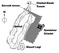 Kandahar fortifications.jpg 2,344 × 2,107; 486 KB
 Kandahar.png 722 × 691; 731 KB
 King Abdur Rahman Khan and map of Kandahar.jpg 3,306 × 4,678; 5.25 MB
 Map of the Hotak Empire 1715, Mirwais Hotak.png 1,518 × 829; 104 KB
 Plan of Kandahar by Tytler.jpg 3,624 × 4,720; 3.06 MB


.jpg)
_vol._1%27_(11245078223).jpg)


.jpg)
.jpg)