Category:Maps of Kursk Governorate 1917—1928 (Soviet period)
Jump to navigation
Jump to search
Media in category "Maps of Kursk Governorate 1917—1928 (Soviet period)"
The following 10 files are in this category, out of 10 total.
-
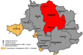
 Belgorod uyezd (1924-1928) schematic.png 4,200 × 2,800; 366 KB
-
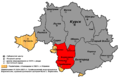
 Borisovka uyezd (Kursk Gubernia) schematic.png 3,800 × 2,800; 302 KB
-
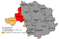
 Grayvoron uyezd (1925-1928) schematic.png 4,350 × 2,800; 405 KB
-
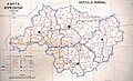
 Kursk gubernia (1924-1928).png 2,560 × 1,600; 760 KB
-
 Kursk uyezd (1924-1928) schematic.png 4,100 × 2,750; 359 KB
-
 Lgov uyezd (1924-1928) schematic.png 4,100 × 2,750; 363 KB
-
 Rylsk uyezd (1924-1928) schematic.png 4,200 × 2,800; 369 KB
-
 Shchigry uyezd (1924-1928) schematic.png 4,100 × 2,750; 366 KB
-
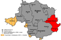 Stary Oskol uyezd (1924-1928) schematic.png 4,100 × 2,750; 361 KB
-
 Курская губерния 1924.jpg 2,862 × 1,751; 777 KB
_schematic.png)
_schematic.png)
_schematic.png)
.png)
_schematic.png)
_schematic.png)
_schematic.png)
_schematic.png)
_schematic.png)
