Category:Maps of KwaZulu-Natal municipalities with 2011 borders
Jump to navigation
Jump to search
This category contains maps of municipalities in KwaZulu-Natal province of South Africa that show the the municipal borders as they were after the municipal election of 18 May 2011. The borders of many municipalities across the country changed again in 2016.
Media in category "Maps of KwaZulu-Natal municipalities with 2011 borders"
The following 76 files are in this category, out of 76 total.
-
 Map of KwaZulu-Natal with districts labelled (2011).svg 712 × 805; 583 KB
-
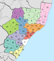
 Map of KwaZulu-Natal with municipalities blank (2011).svg 712 × 805; 1.43 MB
-
 Map of KwaZulu-Natal with Abaqulusi highlighted (2011).svg 712 × 805; 497 KB
-
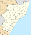
 Map of KwaZulu-Natal with Amajuba highlighted (2011).svg 712 × 805; 500 KB
-
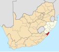
 Map of South Africa with Amajuba highlighted (2011).svg 809 × 709; 481 KB
-
 Blank map of KwaZulu-Natal (2011).svg 663 × 754; 484 KB
-
 Map of KwaZulu-Natal with Dannhauser highlighted (2011).svg 712 × 805; 493 KB
-
 Map of KwaZulu-Natal with eDumbe highlighted (2011).svg 712 × 805; 496 KB
-
 Map of KwaZulu-Natal with eMadlangeni highlighted (2011).svg 712 × 805; 501 KB
-
 Map of KwaZulu-Natal with Emnambithi-Ladysmith highlighted (2011).svg 712 × 805; 497 KB
-
 Map of KwaZulu-Natal with Endumeni highlighted (2011).svg 712 × 805; 492 KB
-
 Map of KwaZulu-Natal with eThekwini highlighted (2011).svg 712 × 805; 499 KB
-
 Map of South Africa with eThekwini highlighted (2011).svg 809 × 709; 479 KB
-
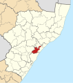
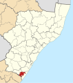 Map of KwaZulu-Natal with Ezingoleni highlighted (2011).svg 712 × 805; 494 KB
-
 Map of KwaZulu-Natal with Greater Kokstad highlighted (2011).svg 712 × 805; 499 KB
-
 Map of KwaZulu-Natal with Hibiscus Coast highlighted (2011).svg 712 × 805; 497 KB
-
 Map of KwaZulu-Natal with Hlabisa highlighted (2011).svg 712 × 805; 493 KB
-
 Map of KwaZulu-Natal with iLembe highlighted (2011).svg 712 × 805; 509 KB
-
 Map of South Africa with iLembe highlighted (2011).svg 809 × 709; 482 KB
-
 Map of KwaZulu-Natal with Imbabazane highlighted (2011).svg 712 × 805; 491 KB
-
 Map of KwaZulu-Natal with Impendle highlighted (2011).svg 712 × 805; 493 KB
-
 Map of KwaZulu-Natal with Indaka highlighted (2011).svg 712 × 805; 492 KB
-
 Map of KwaZulu-Natal with Ingwe highlighted (2011).svg 712 × 805; 496 KB
-
 Map of KwaZulu-Natal with Jozini highlighted (2011).svg 712 × 805; 500 KB
-
 Map of KwaZulu-Natal with Kwa Sani highlighted (2011).svg 712 × 805; 496 KB
-
 Map of KwaZulu-Natal with KwaDukuza highlighted (2011).svg 712 × 805; 493 KB
-
 Map of KwaZulu-Natal with Mandeni highlighted (2011).svg 712 × 805; 493 KB
-
-
 Map of KwaZulu-Natal with Maphumulo highlighted (2011).svg 712 × 805; 497 KB
-
 Map of KwaZulu-Natal with Mbonambi highlighted (2011).svg 712 × 805; 494 KB
-
 Map of KwaZulu-Natal with Mkhambathini highlighted (2011).svg 712 × 805; 495 KB
-
 Map of KwaZulu-Natal with Mpofana highlighted (2011).svg 712 × 805; 492 KB
-
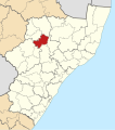
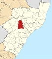 Map of KwaZulu-Natal with Msinga highlighted (2011).svg 712 × 805; 499 KB
-
 Map of KwaZulu-Natal with Msunduzi highlighted (2011).svg 712 × 805; 491 KB
-
 Map of KwaZulu-Natal with Mthonjaneni highlighted (2011).svg 712 × 805; 495 KB
-
 Map of KwaZulu-Natal with Mtubatuba highlighted (2011).svg 712 × 805; 495 KB
-
 Map of KwaZulu-Natal with Ndwedwe highlighted (2011).svg 712 × 805; 496 KB
-
 Map of KwaZulu-Natal with Newcastle highlighted (2011).svg 712 × 805; 497 KB
-
 Map of KwaZulu-Natal with Nkandla highlighted (2011).svg 712 × 805; 502 KB
-
 Map of KwaZulu-Natal with Nongoma highlighted (2011).svg 712 × 805; 502 KB
-
 Map of KwaZulu-Natal with Nquthu highlighted (2011).svg 712 × 805; 500 KB
-
 Map of KwaZulu-Natal with Ntambanana highlighted (2011).svg 712 × 805; 494 KB
-
 Map of KwaZulu-Natal with Okhahlamba highlighted (2011).svg 712 × 805; 499 KB
-
 Map of KwaZulu-Natal with Richmond highlighted (2011).svg 712 × 805; 494 KB
-
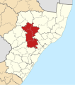
 Map of KwaZulu-Natal with Sisonke highlighted (2011).svg 712 × 805; 511 KB
-
 Map of South Africa with Sisonke highlighted (2011).svg 809 × 709; 483 KB
-
 Map of KwaZulu-Natal with The Big Five False Bay highlighted (2011).svg 712 × 805; 497 KB
-
 Map of KwaZulu-Natal with Ubuhlebezwe highlighted (2011).svg 712 × 805; 496 KB
-
 Map of KwaZulu-Natal with Ugu highlighted (2011).svg 712 × 805; 510 KB
-
 Map of South Africa with Ugu highlighted (2011).svg 809 × 709; 482 KB
-
 Map of KwaZulu-Natal with Ulundi highlighted (2011).svg 712 × 805; 499 KB
-
 Map of KwaZulu-Natal with Umdoni highlighted (2011).svg 712 × 805; 491 KB
-
 Map of KwaZulu-Natal with uMgungundlovu highlighted (2011).svg 712 × 805; 509 KB
-
 Map of South Africa with uMgungundlovu highlighted (2011).svg 809 × 709; 484 KB
-
 Map of KwaZulu-Natal with uMhlabuyalingana highlighted (2011).svg 712 × 805; 497 KB
-
 Map of KwaZulu-Natal with uMhlathuze highlighted (2011).svg 712 × 805; 494 KB
-
 Map of KwaZulu-Natal with uMkhanyakude highlighted (2011).svg 712 × 805; 509 KB
-
 Map of South Africa with uMkhanyakude highlighted (2011).svg 809 × 709; 483 KB
-
 Map of KwaZulu-Natal with uMlalazi highlighted (2011).svg 712 × 805; 503 KB
-
 Map of KwaZulu-Natal with uMngeni highlighted (2011).svg 712 × 805; 491 KB
-
 Map of KwaZulu-Natal with uMshwathi highlighted (2011).svg 712 × 805; 497 KB
-
 Map of KwaZulu-Natal with Umtshezi highlighted (2011).svg 712 × 805; 493 KB
-
 Map of KwaZulu-Natal with uMuziwabantu highlighted (2011).svg 712 × 805; 497 KB
-
 Map of KwaZulu-Natal with Umvoti highlighted (2011).svg 712 × 805; 500 KB
-
 Map of KwaZulu-Natal with Umzimkhulu highlighted (2011).svg 712 × 805; 500 KB
-
 Map of KwaZulu-Natal with uMzinyathi highlighted (2011).svg 712 × 805; 511 KB
-
 Map of South Africa with uMzinyathi highlighted (2011).svg 809 × 709; 484 KB
-
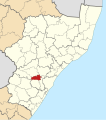
 Map of KwaZulu-Natal with Umzumbe highlighted (2011).svg 712 × 805; 496 KB
-
 Map of KwaZulu-Natal with uPhongolo highlighted (2011).svg 712 × 805; 500 KB
-
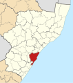
 Map of KwaZulu-Natal with uThukela highlighted (2011).svg 712 × 805; 503 KB
-
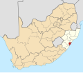
 Map of South Africa with uThukela highlighted (2011).svg 809 × 709; 482 KB
-
 Map of KwaZulu-Natal with uThungulu highlighted (2011).svg 712 × 805; 515 KB
-
 Map of South Africa with uThungulu highlighted (2011).svg 809 × 709; 484 KB
-
 Map of KwaZulu-Natal with Vulamehlo highlighted (2011).svg 712 × 805; 493 KB
-
 Map of KwaZulu-Natal with Zululand highlighted (2011).svg 712 × 805; 512 KB
-
 Map of South Africa with Zululand highlighted (2011).svg 809 × 709; 484 KB
.svg)
.svg)
.svg)
.svg)
.svg)
.svg)
.svg)
.svg)
.svg)
.svg)
.svg)
.svg)
.svg)
.svg)
.svg)
.svg)
.svg)
.svg)
.svg)
.svg)
.svg)
.svg)
.svg)
.svg)
.svg)
.svg)
.svg)
.svg)
.svg)
.svg)
.svg)
.svg)
.svg)
.svg)
.svg)
.svg)
.svg)
.svg)
.svg)
.svg)
.svg)
.svg)
.svg)
.svg)
.svg)
.svg)
.svg)
.svg)
.svg)
.svg)
.svg)
.svg)
.svg)
.svg)
.svg)
.svg)
.svg)
.svg)
.svg)
.svg)
.svg)
.svg)
.svg)
.svg)
.svg)
.svg)
.svg)
.svg)
.svg)
.svg)
.svg)
.svg)
.svg)
.svg)
.svg)
.svg)