Category:Maps of Lescar
Jump to navigation
Jump to search
Wikimedia category | |||||
| Upload media | |||||
| Instance of | |||||
|---|---|---|---|---|---|
| Category combines topics | |||||
| Lescar | |||||
commune in Pyrénées-Atlantiques, France    | |||||
| Pronunciation audio | |||||
| Instance of | |||||
| Location |
| ||||
| Located in or next to body of water | |||||
| Population |
| ||||
| Area |
| ||||
| Elevation above sea level |
| ||||
| official website | |||||
 | |||||
Media in category "Maps of Lescar"
The following 12 files are in this category, out of 12 total.
-
 64335-Lescar-argile.jpg 3,057 × 2,480; 630 KB
-
 64335-Lescar-Routes-Hydro.png 3,507 × 2,480; 5.29 MB
-
 64335-Lescar-Sols.png 3,270 × 2,598; 4.96 MB
-
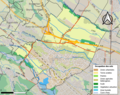
 64335-Lescar-ZNIEFF1.png 3,057 × 2,480; 6.15 MB
-
 64335-Lescar-ZNIEFF2.png 5,866 × 4,133; 15.26 MB
-
 Carte Patrimoine Lescar.png 993 × 552; 688 KB
-
 Diocèse Lescar 1789.svg 2,000 × 1,922; 801 KB
-
 Lescar Limite Communale.jpg 1,275 × 793; 344 KB
-
 Map commune FR insee code 64335.png 756 × 605; 85 KB
-
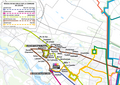 Réseau IDELIS - Lescar.png 3,507 × 2,480; 2.01 MB
-
 ZNIEFF Lescar.png 921 × 722; 657 KB
-
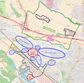 Zonage Lescar.png 725 × 715; 503 KB


