Category:Maps of Limpopo municipalities with 2011 borders
Jump to navigation
Jump to search
This category contains maps of municipalities in Limpopo province of South Africa that show the the municipal borders as they were after the municipal election of 18 May 2011. The borders of many municipalities across the country changed again in 2016.
Media in category "Maps of Limpopo municipalities with 2011 borders"
The following 39 files are in this category, out of 39 total.
-
 Map of Limpopo with districts labelled (2011).svg 925 × 621; 305 KB
-
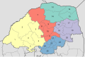
 Map of Limpopo with municipalities blank (2011).svg 925 × 621; 680 KB
-
 Map of Limpopo with Aganang highlighted (2011).svg 925 × 621; 265 KB
-
 Map of Limpopo with Ba-Phalaborwa highlighted (2011).svg 925 × 621; 274 KB
-
 Map of Limpopo with Bela-Bela highlighted (2011).svg 925 × 621; 268 KB
-
 Blank map of Limpopo (2011).svg 850 × 588; 280 KB
-
 Map of Limpopo with Blouberg highlighted (2011).svg 925 × 621; 270 KB
-
 Map of Limpopo with Capricorn highlighted (2011).svg 925 × 621; 281 KB
-
 Map of South Africa with Capricorn highlighted (2011).svg 809 × 709; 481 KB
-
 Map of Limpopo with Elias Motsoaledi highlighted (2011).svg 925 × 621; 268 KB
-
 Map of Limpopo with Ephraim Mogale highlighted (2011).svg 925 × 621; 268 KB
-
 Map of Limpopo with Fetakgomo highlighted (2011).svg 925 × 621; 267 KB
-
 Map of Limpopo with Greater Giyani highlighted (2011).svg 925 × 621; 276 KB
-
 Map of Limpopo with Greater Letaba highlighted (2011).svg 925 × 621; 266 KB
-
 Map of Limpopo with Greater Tubatse highlighted (2011).svg 925 × 621; 267 KB
-
 Map of Limpopo with Lepelle-Nkumpi highlighted (2011).svg 925 × 621; 271 KB
-
 Map of Limpopo with Lephalale highlighted (2011).svg 925 × 621; 286 KB
-
 Map of Limpopo with Makhado highlighted (2011).svg 925 × 621; 271 KB
-
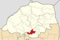
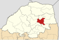
 Map of Limpopo with Makhuduthamaga highlighted (2011).svg 925 × 621; 268 KB
-
-
 Map of Limpopo with Greater Tzaneen highlighted (2011).svg 925 × 621; 268 KB
-
 Map of Limpopo with Maruleng highlighted (2011).svg 925 × 621; 268 KB
-
 Map of Limpopo with Modimolle highlighted (2011).svg 925 × 621; 268 KB
-
 Map of Limpopo with Mogalakwena highlighted (2011).svg 925 × 621; 270 KB
-
 Map of Limpopo with Molemole highlighted (2011).svg 925 × 621; 267 KB
-
 Map of Limpopo with Mookgophong highlighted (2011).svg 925 × 621; 267 KB
-
 Map of Limpopo with Mopani highlighted (2011).svg 925 × 621; 277 KB
-
 Map of South Africa with Mopani highlighted (2011).svg 809 × 709; 479 KB
-
 Map of Limpopo with Musina highlighted (2011).svg 925 × 621; 276 KB
-
 Map of Limpopo with Mutale highlighted (2011).svg 925 × 621; 271 KB
-
 Map of Limpopo with Polokwane highlighted (2011).svg 925 × 621; 266 KB
-
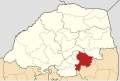
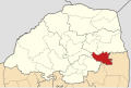
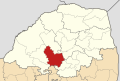
 Map of Limpopo with Sekhukhune highlighted (2011).svg 925 × 621; 276 KB
-
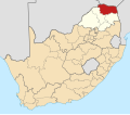
 Map of South Africa with Sekhukhune highlighted (2011).svg 809 × 709; 479 KB
-
 Map of Limpopo with Thabazimbi highlighted (2011).svg 925 × 621; 279 KB
-
 Map of Limpopo with Thulamela highlighted (2011).svg 925 × 621; 274 KB
-
 Map of Limpopo with Vhembe highlighted (2011).svg 925 × 621; 286 KB
-
 Map of South Africa with Vhembe highlighted (2011).svg 809 × 709; 482 KB
-
 Map of Limpopo with Waterberg highlighted (2011).svg 925 × 621; 294 KB
-
 Map of South Africa with Waterberg highlighted (2011).svg 809 × 709; 485 KB
.svg)
.svg)
.svg)
.svg)
.svg)
.svg)
.svg)
.svg)
.svg)
.svg)
.svg)
.svg)
.svg)
.svg)
.svg)
.svg)
.svg)
.svg)
.svg)
.svg)
.svg)
.svg)
.svg)
.svg)
.svg)
.svg)
.svg)
.svg)
.svg)
.svg)
.svg)
.svg)
.svg)
.svg)
.svg)
.svg)
.svg)
.svg)
.svg)