Category:Maps of Montbert (Loire-Atlantique)
Jump to navigation
Jump to search
Subcategories
This category has only the following subcategory.
Media in category "Maps of Montbert (Loire-Atlantique)"
The following 7 files are in this category, out of 7 total.
-
 44102-Montbert-Sols.png 3,270 × 2,598; 3.15 MB
-
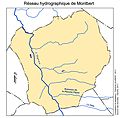 Bassin versant de Montbert.jpg 3,892 × 3,817; 1.3 MB
-
 Carte de Cassini du XVIIIe siècle, centré sur Montbert.png 801 × 527; 609 KB
-
 Extrait du PLU de Montbert.png 16,375 × 11,578; 2.27 MB
-
 Géologie montbert.png 5,600 × 3,400; 2.89 MB
-
 Location Montbert.svg 400 × 320; 12 KB
-
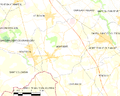 Map commune FR insee code 44102.png 756 × 605; 61 KB


